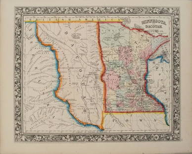
Sold20201860 Mitchell Map of Minnesota and the DakotasTitle/Content of Map: 1860 Mitchell Map of Minnesota and the Dakotas --Minnesota and Dacotah Date: 1860, Philadelphia Cartographer: S Mitchell Size: 10.6 X 13.3 in. This is a rather nice map of MinnesSee Sold Price
Sold20201869 Mitchell Map of Plains States and Colorado --Title/Content of Map: 1869 Mitchell Map of Plains States and Colorado -- XVIII Kansas, Colorado, New Mexico and Indian Territory [verso] XVI Minnesota and Dakota [also] XVII Nebraska Cartographer: S MSee Sold Price
Sold2021Nice 1862 map of Minnesota by MitchellMap of Minnesota at the time of the Dakota War of 1862. In August of that year, along the Minnesota River in the southwestern part of the state, the Dakota tribe began attacking settlers due to the haSee Sold Price
Sold2019Eight (8) Augustus Mitchell MapsCollection of eight maps including New Jersey/Maryland Delaware 1872, Two north and South Carolina 1872 maps (15" x 12"), Minnesota 1890 , Florida and the Carolinas 1860, County map of the state of ArSee Sold Price
Sold20171860 Minnesota and Dacotah, S. Augustus Mitchell, Jr1860 Minnesota and Dacotah, S. Augustus Mitchell, Jr. 10.625 x 13.125 inches. Engraved map with exceptionally bright original hand-coloring. This attractive, historical map depicts the new State ofSee Sold Price
Sold20241860 Mitchell Map of US & Territories with Canada. Inset of Pensacola Bay & Hampton Roads / NorfolkTitle/Content of Map: 1860 Mitchell Map of US & Territories with Canada. Inset of Pensacola Bay & Hampton Roads / Norfolk Harbor. Date Printed: 1860 Cartographer: S. Augustus Mitchell Material/Medium:See Sold Price
Sold20211860 Mitchell Map of New Orleans -- Plan of New OrleansTitle: 1860 Mitchell Map of New Orleans -- Plan of New Orleans Cartographer: S Mitchell Year / Place: 1860, Philadelphia Map Dimension (in.): 9.2 X 11 in. This is a very an attractive map of the CrescSee Sold Price
Sold20201860 Mitchell Map of the Caribbean and Mexico -- Map ofTitle/Content of Map: 1860 Mitchell Map of the Caribbean and Mexico -- Map of Mexico Central America and the West Indies Cartographer: S Mitchell Year/Place: 1860, Philadelphia Size: 13.1 X 21 in. ThiSee Sold Price
Sold20181860 Mitchell Map of the Caribbean and Mexico -- Map ofTitle/Content of Map: 1860 Mitchell Map of the Caribbean and Mexico -- Map of Mexico Central America and the West Indies Date: 1860, Philadelphia Cartographer: S Mitchell Size: 13.1 X 21 in. A highlySee Sold Price
Sold20211860 Mitchell Map of the Caribbean and Mexico -- Map ofTitle: 1860 Mitchell Map of the Caribbean and Mexico -- Map of Mexico Central America and the West Indies Cartographer: S Mitchell Year / Place: 1860, Philadelphia Map Dimension (in.): 13.1 X 21 in. TSee Sold Price
Sold20191860 Mitchell Map of New Orleans -- Plan of New OrleansTitle: 1860 Mitchell Map of New Orleans -- Plan of New Orleans Date: 1860, Philadelphia Cartographer: S Mitchell Size: 9.2 x 10.9 in. Additional Information: An excellent map of the Crescent City, shoSee Sold Price
Sold20211860 Mitchell Map of New Orleans -- Plan of New OrleansTitle: 1860 Mitchell Map of New Orleans -- Plan of New Orleans Cartographer: S Mitchell Year / Place: 1860, Philadelphia Map Dimension (in.): 9.2 x 10.9 in. This is an excellent map of the Crescent CiSee Sold Price
Sold20201860 Mitchell Map of Florida, South and North CarolinaTitle/Content of Map: 1860 Mitchell Map of Florida, South and North Carolina -- County Map of Florida on page with Map of South Carolina, on page with County Map of North Carolina Cartographer: S MitcSee Sold Price
Sold20231860 Mitchell Map of Florida, South and North Carolina -- County Map of Florida on page with Map ofTitle: 1860 Mitchell Map of Florida, South and North Carolina -- County Map of Florida on page with Map of South Carolina, on page with County Map of North Carolina Cartographer: S Mitchell Year / PlaSee Sold Price
Sold20211860 Mitchell Map of Florida, South and North CarolinaTitle: 1860 Mitchell Map of Florida, South and North Carolina -- County Map of Florida on page with Map of South Carolina, on page with County Map of North Carolina Cartographer: S Mitchell Year / PlaSee Sold Price
Sold20181860 Mitchell Map of Florida, South and North CarolinaTitle/Content of Map: 1860 Mitchell Map of Florida, South and North Carolina -- County Map of Florida on page with Map of South Carolina, on page with County Map of North Carolina Date Printed: 1860,See Sold Price
Sold20201860 Mitchell Map of Florida, South and North CarolinaTitle/Content of Map: 1860 Mitchell Map of Florida, South and North Carolina -- County Map of Florida on page with Map of South Carolina, on page with County Map of North Carolina Date: 1860, PhiladelSee Sold Price
Sold20191860 Mitchell Map of Baltimore -- Plan of BaltimoreTitle: 1860 Mitchell Map of Baltimore -- Plan of Baltimore Date: 1860, Philadelphia Cartographer: S Mitchell Size: 9 X 11.2 in. Additional Information: A very nice map of Baltimore, identifying the vaSee Sold Price
Sold20181860 Mitchell Map of the US Northeast States -- CountyTitle/Content of Map: 1860 Mitchell Map of the US Northeast States -- County Map of the States of New York, New Hampshire, Vermont, Massachusetts, Rhode Id. & Connecticut Date: 1860, Philadelphia CartSee Sold Price
Sold20191860 Mitchell Map of Florida and South Carolina --Title/Content of Map: 1860 Mitchell Map of Florida and South Carolina -- County Map Of Florida [on sheet with] Map Of South Carolina Date: 1860, PhiladelphiaCartographer: S Mitchell Size: 10.8 x 13.2See Sold Price
Sold20241860 Mitchell Map of Asia -- Map of Asia Showing its Gt. Political Divisions?Title: 1860 Mitchell Map of Asia -- Map of Asia Showing its Gt. Political Divisions? Cartographer: S Mitchell Year / Place: 1860, Philadelphia Map Dimension (in.): 10.5 x 13.5 in. A magnificent map ofSee Sold Price
Sold20221860 Mitchell Map of Mississippi, Louisiana and Arkansas -- Map of Louisiana, Mississippi, ArkansasTitle: 1860 Mitchell Map of Mississippi, Louisiana and Arkansas -- Map of Louisiana, Mississippi, Arkansas Cartographer: S Mitchell Year / Place: 1860, Philadelphia Map Dimension (in.): 13.5 X 10.7 inSee Sold Price
Sold20201860 Mitchell Map of Asia -- Map of Asia Showing itsTitle/Content of Map: 1860 Mitchell Map of Asia -- Map of Asia Showing its Gt. Political DivisionsÂ… Cartographer: S Mitchell Year/Place: 1860, Philadelphia Size: 10.5 x 13.5 in. A magnificent mapSee Sold Price
Sold20181860 Mitchell Map od Asia -- Map of Asia Showing itsTitle/Content of Map: 1860 Mitchell Map od Asia -- Map of Asia Showing its Gt. Political Divisions… Date Printed: 1860, Philadelphia Cartographer: S Mitchell Size: 10.5 x 13.5 in. A magnificent mapSee Sold Price
Featured1 day LeftJasper521878 Mitchell Map of Virginia and West Virginia [verso] New Jersey, Maryland and Delaware -- County$45
2 days LeftJasper52The Island of Borneo by Edward Weller. Sarawak Sabah Brunei Kalimantan 1860 map$50(1 bid)
1 day LeftJasper521878 Mitchell Map of Washington, Oregon, Idaho, much of Montana [verso] Territory of Idaho$55


![1869 Mitchell Map of Plains States and Colorado --: Title/Content of Map: 1869 Mitchell Map of Plains States and Colorado -- XVIII Kansas, Colorado, New Mexico and Indian Territory [verso] XVI Minnesota and Dakota [also] XVII Nebraska Cartographer: S M](https://p1.liveauctioneers.com/5584/179983/90569362_1_x.jpg?height=310&quality=70&version=1601417445)


![1860 Mitchell Map of Florida and South Carolina --: Title/Content of Map: 1860 Mitchell Map of Florida and South Carolina -- County Map Of Florida [on sheet with] Map Of South Carolina Date: 1860, PhiladelphiaCartographer: S Mitchell Size: 10.8 x 13.2](https://p1.liveauctioneers.com/5584/144953/73284299_1_x.jpg?height=310&quality=70&version=1562102885)


![1878 Mitchell Map of Virginia and West Virginia [verso] New Jersey, Maryland and Delaware -- County (1 of 2)](https://p1.liveauctioneers.com/5584/329422/177662152_1_x.jpg?height=282&quality=70&version=1715717898)


![1878 Mitchell Map of Washington, Oregon, Idaho, much of Montana [verso] Territory of Idaho (1 of 2)](https://p1.liveauctioneers.com/5584/329422/177662232_1_x.jpg?height=282&quality=70&version=1715717898)


