Sold20201860 Mitchell Map of Florida, South and North CarolinaTitle/Content of Map: 1860 Mitchell Map of Florida, South and North Carolina -- County Map of Florida on page with Map of South Carolina, on page with County Map of North Carolina Cartographer: S MitcSee Sold Price
Sold20231860 Mitchell Map of Florida, South and North Carolina -- County Map of Florida on page with Map ofTitle: 1860 Mitchell Map of Florida, South and North Carolina -- County Map of Florida on page with Map of South Carolina, on page with County Map of North Carolina Cartographer: S Mitchell Year / PlaSee Sold Price
Sold20211860 Mitchell Map of Florida, South and North CarolinaTitle: 1860 Mitchell Map of Florida, South and North Carolina -- County Map of Florida on page with Map of South Carolina, on page with County Map of North Carolina Cartographer: S Mitchell Year / PlaSee Sold Price
Sold20181860 Mitchell Map of Florida, South and North CarolinaTitle/Content of Map: 1860 Mitchell Map of Florida, South and North Carolina -- County Map of Florida on page with Map of South Carolina, on page with County Map of North Carolina Date Printed: 1860,See Sold Price
Sold20201860 Mitchell Map of Florida, South and North CarolinaTitle/Content of Map: 1860 Mitchell Map of Florida, South and North Carolina -- County Map of Florida on page with Map of South Carolina, on page with County Map of North Carolina Date: 1860, PhiladelSee Sold Price
Sold2017Mitchell Map of Florida, South and North Carolina, 1860Title: 1860 Mitchell Map of Florida, South and North Carolina Cartographer: S Mitchell Published: 1860, Philadelphia Measurements: 10.6 X 13.5 in. County Map of Florida on page with Map of South CarolSee Sold Price
Sold2019Samuel Augustus Mitchell (1790-1868), "County Map ofSamuel Augustus Mitchell (1790-1868), "County Map of Florida, North Carolina, South Carolina," 1860, H. - 12 1/4 in., W. - 15 3/8 in.See Sold Price
Sold2018Two Civil War Era Mitchell MapsMap of North America Showing Its Political Divisions and county maps of North Carolina, South Carolina, and Florida on one sheet (Philadelphia: S. Augustus Mitchell, 1860). Not framed. 15.25 x 12.25 iSee Sold Price
Sold2019Eight (8) Augustus Mitchell MapsCollection of eight maps including New Jersey/Maryland Delaware 1872, Two north and South Carolina 1872 maps (15" x 12"), Minnesota 1890 , Florida and the Carolinas 1860, County map of the state of ArSee Sold Price
Sold20181863 Mitchell Map of Florida, South and North CarolinaTitle/Content of Map: 1863 Mitchell Map of Florida, South and North Carolina -- County Map of Florida on page with Map of South Carolina, on page with County Map of North Carolina Date: 1863, PhiladelSee Sold Price
Sold20191860 Mitchell Map of Florida and South Carolina --Title/Content of Map: 1860 Mitchell Map of Florida and South Carolina -- County Map Of Florida [on sheet with] Map Of South Carolina Date: 1860, PhiladelphiaCartographer: S Mitchell Size: 10.8 x 13.2See Sold Price
Sold2017Mitchell: Antique Map of Florida & South Carolina, 1860Map: 1860 Mitchell Map of Florida and South Carolina -- County Map of Florida [on sheet with] County Map of South Carolina Date Printed: 1860, Philadelphia Cartographer: S Mitchell Size: 9.1 x 10.6 inSee Sold Price
Sold2023Rare 1st state of Florida map from 1st printing of 1860 atlasFirst edition, first state of S. A. Mitchell Jr.'s County Map of Florida/County Map of South Carolina. Maps from Mitchell Jr’s first printing of his first New General Atlas are distinguished bySee Sold Price
Sold20221877 Mitchell Map of North and South Carolina -- North and South CarolinaTitle: 1877 Mitchell Map of North and South Carolina -- North and South Carolina Cartographer: S Mitchell Date/Place: 1877 Philadelphia Dimensions: 10.5 x 13.5 in. Description: This is an excellent anSee Sold Price
Sold20211887 Mitchell Map of North and South Carolina -- NorthTitle: 1887 Mitchell Map of North and South Carolina -- North and South Carolina Cartographer: S Mitchell Year / Place: 1887, Philadelphia Map Dimension (in.): 11.3 X 14 in. A very nice map of the CarSee Sold Price
Sold20211884 Mitchell Map of North and South Carolina -- NorthTitle: 1884 Mitchell Map of North and South Carolina -- North and South Carolina Cartographer: S Mitchell Year / Place: 1884, Philadelphia Map Dimension (in.): 11.3 X 14 in. This is a very nice map ofSee Sold Price
Sold20181876 Mitchell Map of North and South Carolina -- NorthReserve Reduced! Title/Content of Map: 1876 Mitchell Map of North and South Carolina -- North and South Carolina Date: 1876 Philadelphia Cartographer: S Mitchell Size: 10.5 x 13.5 in. Excellent and hiSee Sold Price
Sold2016(4) 1838 BRADFORD Maps: NC, SC, GA, FL.[United States/South] 4 Maps. ++ NORTH CAROLINA. ++ SOUTH CAROLINA. ++ GEORGIA. ++ FLORIDA. ++ +Maps 28, 30, 31, 32 from T. G. Bradford, “An Illustrated Atlas, Geographical, Statistical, And HistoriSee Sold Price
Sold20181867 Mitchell Map of North and South Carolina -- CountyTitle/Content of Map: 1867 Mitchell Map of North and South Carolina -- County Map of North and South Carolina Date: 1867, Philadelphia Cartographer: S Mitchell Size: 11.5 x 13.8 in. This is a handsomeSee Sold Price
Sold2018Big map oriental United States, 1875, steel etching,Very beautiful map of oriental United States (Louisiana, Mississipi, Alabama, Georgia, Florida, South Carolina, North Carolina, Tennessee, Arkansas, Virginia, Kentucky, Missouri, Kansas, Nebraska, IowSee Sold Price
Sold20231891 Mitchell Map of Maryland, Virginia, North Carolina and South Carolina -- Map of Maryland,Title: 1891 Mitchell Map of Maryland, Virginia, North Carolina and South Carolina -- Map of Maryland, Virginia, North Carolina and South Carolina Cartographer: S Mitchell Year/Place: 1891, PhiladelphiSee Sold Price
Sold2020Florida & North CarolinaTitle: Florida & North Carolina Date/Period: 1862 Materials: steel engraved Dimensions: 15 1/2” x 12 1/2” By Augustus S. Mitchell. Hand colored engraved map. From ‘the New General Atlas’. PublSee Sold Price
Sold20166 assorted folding maps6 assorted folding maps including 1931 road map of Florida; New York to Buffalo turist guide; 1930 road map of North & South Carolina. Used condition; stains; tears; written on.See Sold Price
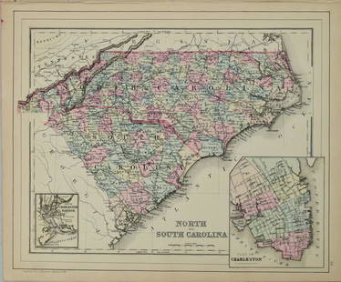
Sold20191867 NORTH + SOUTH CAROLINA MAPOriginal antique map of North and South Carolina published by S. Augustus Mitchell, Jr. Includes inset maps of Charleston Harbor in the bottom left and a Plan of Charleston in the bottom right. It feaSee Sold Price
6 days LeftTrillium Antique Prints & Rare BooksSanson - Map of Florida (encompassing most of Southeast North America)$75(1 bid)
5 days LeftFreeman's | Hindman[CIVIL WAR - SOUTH CAROLINA ACT OF SECESSION]. An Ordinance. To dissolve the Union between the State$7,500
4 days LeftJasper52Central America. Mexico Chiapa, Tabasco & Yucatan. Belize &c. SWANSTON 1860 map$60
4 days LeftJasper52South America, North. Amazonia Brazil Venezuela Colombia Ecuador TIMES 1900 map$40
5 days LeftFreeman's | Hindman[CIVIL WAR]. Charleston Mercury Extra:...The Union is Dissolved! [Charleston, SC]: [Charleston$7,500
4 days LeftLeland LittleEldon Willis (NC, 1908-1981) and Elmer Salter (NC, 1902-1964), Published Pintail from Hog Island$50
4 days LeftJasper52AMAZONIA showing "El Dorado?" & Missions. Brazil Ecuador Colombia SDUK 1874 map$120


![1860 Mitchell Map of Florida and South Carolina --: Title/Content of Map: 1860 Mitchell Map of Florida and South Carolina -- County Map Of Florida [on sheet with] Map Of South Carolina Date: 1860, PhiladelphiaCartographer: S Mitchell Size: 10.8 x 13.2](https://p1.liveauctioneers.com/5584/144953/73284299_1_x.jpg?height=310&quality=70&version=1562102885)
![Mitchell: Antique Map of Florida & South Carolina, 1860: Map: 1860 Mitchell Map of Florida and South Carolina -- County Map of Florida [on sheet with] County Map of South Carolina Date Printed: 1860, Philadelphia Cartographer: S Mitchell Size: 9.1 x 10.6 in](https://p1.liveauctioneers.com/5584/109294/56069180_1_x.jpg?height=310&quality=70&version=1505338533)


![(4) 1838 BRADFORD Maps: NC, SC, GA, FL.: [United States/South] 4 Maps. ++ NORTH CAROLINA. ++ SOUTH CAROLINA. ++ GEORGIA. ++ FLORIDA. ++ +Maps 28, 30, 31, 32 from T. G. Bradford, “An Illustrated Atlas, Geographical, Statistical, And Histori](https://p1.liveauctioneers.com/179/85723/44107998_1_x.jpg?height=310&quality=70&version=1457209205)


![[CIVIL WAR - SOUTH CAROLINA ACT OF SECESSION]. An Ordinance. To dissolve the Union between the State (1 of 2)](https://p1.liveauctioneers.com/197/329785/177758237_1_x.jpg?height=282&quality=70&version=1715625218)


![[CIVIL WAR]. Charleston Mercury Extra:...The Union is Dissolved! [Charleston, SC]: [Charleston (1 of 2)](https://p1.liveauctioneers.com/197/329785/177758238_1_x.jpg?height=282&quality=70&version=1715625218)


