Sold2022Large chart of Strait of Magellan 1787Heading: (South America) Author: Schraembl, Franz Anton Title: Karte der Magellanischen Strasse von Herrn Don Iuan de la Cruz Cano y Olmedillo... Place Published: Wien Publisher:Jos. Gerstner DatSee Sold Price
Sold2018Benard: Magellan Strait with Coastal ProfilesA large-scale dramatic chart of the Magellan Strait with extensive coastal detail and four coastal profiles, based on the observations and discoveries of Captains Byron, Wallis, and Carteret.; G642; BSee Sold Price
Sold2024Antique Map - South America - Chart of Strait of Magellan - Patagonia - ChileThis large, original copper engraved, antique map, a chart of the Straits of Magellan, South America and the Patagonian & South Chilean shoreline was engraved by Robert Benard and published in theSee Sold Price
Sold2019Chastenet-Puységur: Large Hispaniola Chart, 1787Cartographer: Chastenet-Puységur/Dépôt de la Marine Place/Date: Paris / 1787 Size: 37 1/4" x 23 1/2" Condition: beautifully colored; split in upper margin and border and along bottom centerfold expSee Sold Price
Sold2018Bellin: Chart of the Strait of Magellan 1760Map: Carte Reduite du Detroit de Magellan Cartographer: Bellin Place & Date: Paris / 1753/1760 Size: 13 1/2" x 9" Condition: b&w; old fold; margins extended with contemporary paper to fit the size ofSee Sold Price
Sold201818th C. Map of Australia w/Strait of Magellan18th c. framed map of Australia w/the Strait of Magellan. Copper engraved map, hand colored, w/ large colored pictorial cartouche, by Bernaidus Joannis Manasterienfis. Visible paper measures approximaSee Sold Price
Sold2023Large chart of Pacific & Indian Oceans 1813Heading: Author: Espinosa y Tello, Josef Title: Carta general para las navegaciones a la India Oriental por el Mar del Sur y el Grande Oceano que separa el Asia de la America Place Published: LondonSee Sold Price
Sold2016Large chart of the Azores 1755Heading: Author: Depot de la Marine Title: Carte Réduite des Isles Açores pour servir aux Vaisseaux du Roi Dréssée au Dépôt des Cartes, Plans, et Journeaux de la Marine... Place Published: [ParSee Sold Price
Sold2021George Eldridge, Large Chart of Chesapeake Bay 1868George Eldridge / G. W. Boynton, Sc., ELDRIDGEÕS CHART OF CHESAPEAKE BAY, JAMES, YORK, RAPPAHANNOCK AND POTOMAC RIVERS. Compiled from the latest surveys by GEORGE ELDRIDGE, HYDROGRAPHER. Boston: S. TSee Sold Price
Sold2019Verbeek 1905 Large Chart. Topography of Java, IndonesiaLarge Folio Lithograph Published 1905, Batavia for "Geologische beschrijving van Ambon" by Rogier Diederik Marius Verbeek. Centre fold as issued. Paper Size: 26 x 16.5 inch (66 x 42cm) Several marginSee Sold Price
Sold2018Iceland.- Bellin (Jacques Nicolas) Carte Reduite deIceland.- Bellin (Jacques Nicolas) Carte Reduite de l'Islande et des Mers qui en sont Voisines ..., large chart of Iceland with the Faroe Islands in the lower right corner, extensive title and descripSee Sold Price
Sold2022Martha’s Vineyard, 1855 Coastal SurveyPainstakingly hand-colored large chart showing Martha’s Vineyard and the Falmouth area of Cape Cod. Minutely detailed with hundreds of soundings shown. “Preliminary Chart of Muskeget ChannSee Sold Price
Sold2022Nystrom Anatomical Roll Out Chart Muscles 1918,ScienceNystrom Anatomical Roll Out Chart Muscles 1918. Marked Copyright 1918, A.J. Nystrom & Co Publishers, Chicago, American Edition, Chart No. 2, large chart shows the muscles of the human body. FascinatinSee Sold Price
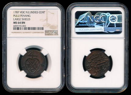
Sold2018Malaysia Pulu Penang 1c 1787 large shieldMalaysia Pulu Penang, Cent, (KM.4), 1787, VEIC, large shield, NGC MS64BN. From the Peninsula Collection.See Sold Price
Sold2017Mercator: Strait of Magellan, Terra del Fuego, 1613Exquisita & magno aliquot mensium periculo Lustrata et iam retecta Freti Magellanici Facies . . . By: Gerard Mercator. Date: 1613 / Amsterdam. Dimensions: 14 x 18 inches (35.5 x 45.7 cm) This is an auSee Sold Price
Sold2023Large 1876 chart of Long Island Sound from Newport to New York. Compiled by George Eldridge, publishLarge 1876 chart of Long Island Sound from Newport to New York. Compiled by George Eldridge, published by S. Thaxter & Son, Boston. Nautical chart with notable coastal towns and landmarks. Canvas backSee Sold Price
Sold20231770 Large Printed Chart of the Troops of FranceColonial America 1770 Dated, "Carte Des Troupes De France, Sur Le Pied Des Ordonnances 1770" ("Chart of the Troops of France, Based on the Ordinances of 1770" 1770-Dated, Pre-Revolutionary War AmericaSee Sold Price
Sold2016Strait of Magellan, Jodocus Hondius 1606-33Title: Freti Magellanici ac novi Freti vulgo Le Maire Subject: Strait of Magellan Maker: Jodocus Hondius Date: 1606-33, Amsterdam Size: 15.1 x 19.25 inches This is one of the best known early maps ofSee Sold Price
Sold2019Strait of Magellan Map[Strait of Magellan Map] , "Fretum Magellannicum", by Theodore De Bry, Frankfurt, 1601, copper engraved, depicting ships, natives, a penguin and a snail, 6 1/2 in. x 11 3/4 in., framed IMPORTANT: AllSee Sold Price
Sold2023J. DE HONDT, COLOR MAP OF STRAITS OF MAGELLANJoost de Hondt (Belgian 1563-1612), "Freti Magel Lanici Ac Novi Freti Vulgo, Le Maitre Exactissima Delineatio", hand colored map of the Straits of Magellan, Le Maire Strait, Fire Lands and the southerSee Sold Price
Sold2023Lot of 3 Books by Rockwell Kent, Voyaging The Strait Of Magellan 1924, Salamina 1935, N by E 19351) Voyaging Southward From The Strait Of Magellan, with illustrations by the Author. Published by Halcyon House, New York 1924, Fourth Printing. Good condition. 2) Salamina, illustrated by the Author.See Sold Price
Sold2022Strait of Magellan from French Cook 1778Heading: (South America) Author: Bernard, Jean Frederic Title: Carte du Detroit de Magellan dans laquelle on an Insere les Observations et les Decouvertes du Capne. Byron, du Capne. Wallis, et du CapnSee Sold Price
Sold20181740 Large Folding Chart Western AtlanticA New Map of Chart of the Western or Atlantic Ocean with part of Europe Africa and America: Shewing the Course of the Galleons, Flota, and C to and from the West Indies, London, printed for E. Cave atSee Sold Price
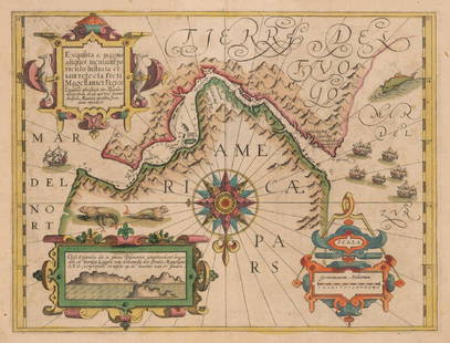
Sold2023Détroit de Magellan. Strait of Magellan. Chile. BONNE 1790 old antique map[Voyage des Capitaines Byron, Vallis et Carteret] Détroit de Magellan avec les Plans des principaux Ports, Bayes &c. de ce Détroit // Havre Swalow ou de l'Hirondelle // Baye du Cap Upright // BaSee Sold Price
Jun 08Leon GalleryPhilippe de Pretot, Etienne Andre (c. 1710 - 1787) and William Walton - Carte de Canal des Isles₱30,000
5 days LeftJasper52Southern Africa Cape of Good Hope-Madagascar ADMIRALTY sea chart 1935 (1955) map$60
5 days LeftJasper52South Namibia coast. Walvis Bay-Orange River ADMIRALTY sea chart 1881 (1954) map$85
Jun 28Galerie Zacke A LARGE AND RARE JAIN PATAKA PAINTING INSCRIBED WITH YANTRAS AND MANTRAS, RAJASTHAN, 16TH CENTURY€500
Jun 28Rail & Road AuctionsLarge Group of Monon Railroad Paper Ephemera - Rule Books, Photographs, Inspection Certificates,$40
1 day LeftMynt AuctionsGEORGE STRAIT COUNTRY MUSIC LEGEND PURE COUNTRY MUELLER/COA SIGNED 8X10 PHOTO$10(1 bid)
5 days LeftMynt AuctionsDan Baird & Mauro Magellan Signed Open All Night 45 RPM Album Cover BAS #BG79205$10
6 days LeftMynt AuctionsGeorge Strait Performer Signed CD Cover w/ Photo Framed King of Country Beckett$10


![Strait of Magellan Map: [Strait of Magellan Map] , "Fretum Magellannicum", by Theodore De Bry, Frankfurt, 1601, copper engraved, depicting ships, natives, a penguin and a snail, 6 1/2 in. x 11 3/4 in., framed IMPORTANT: All](https://p1.liveauctioneers.com/268/150890/76180328_1_x.jpg?height=310&quality=70&version=1569336980)


![Détroit de Magellan. Strait of Magellan. Chile. BONNE 1790 old antique map: [Voyage des Capitaines Byron, Vallis et Carteret] Détroit de Magellan avec les Plans des principaux Ports, Bayes &c. de ce Détroit // Havre Swalow ou de l'Hirondelle // Baye du Cap Upright // Ba](https://p1.liveauctioneers.com/5584/294908/156576972_1_x.jpg?height=310&quality=70&version=1688565030)


