Sold2018Bellin: Chart of the Strait of Magellan 1760Map: Carte Reduite du Detroit de Magellan Cartographer: Bellin Place & Date: Paris / 1753/1760 Size: 13 1/2" x 9" Condition: b&w; old fold; margins extended with contemporary paper to fit the size ofSee Sold Price
Sold2022Large chart of Strait of Magellan 1787Heading: (South America) Author: Schraembl, Franz Anton Title: Karte der Magellanischen Strasse von Herrn Don Iuan de la Cruz Cano y Olmedillo... Place Published: Wien Publisher:Jos. Gerstner DatSee Sold Price
Sold2024Antique Map - South America - Chart of Strait of Magellan - Patagonia - ChileThis large, original copper engraved, antique map, a chart of the Straits of Magellan, South America and the Patagonian & South Chilean shoreline was engraved by Robert Benard and published in theSee Sold Price
Sold2018Benard: Magellan Strait with Coastal ProfilesA large-scale dramatic chart of the Magellan Strait with extensive coastal detail and four coastal profiles, based on the observations and discoveries of Captains Byron, Wallis, and Carteret.; G642; BSee Sold Price
Sold2020Bellin: Isla del Carmen (Port Royal Island), MexicoTitle/Content of Map: Bellin: Isla del Carmen (Port Royal Island), Mexico Date Printed: 1760, Leipzig Cartographer: Bellin Size: 5 7/8" x 7 7/8" A lovely exemplar of Bellin's chart of the island of PoSee Sold Price
Sold2020Bellin: 1750s Coastal Chart of France and SpainTitle/Content of Map: Bellin: 1750s Coastal Chart of France and Spain Date Printed: 1749/1760, Paris Cartographer: Bellin Size: 11" x 9" Bellin's highly detailed chart of the Atlantic and MediterraneaSee Sold Price
Sold20181758 Bellin Chart of the Flags of Sea-Going Nations --Title/Content of Map: 1758 Bellin Chart of the Flags of Sea-Going Nations -- Tableau des Pallions que la Pluspart des Nations Arborent a la Mer Date Printed: 1758, Paris Cartographer: J Bellin Size: 1See Sold Price
Sold2017Carte de l'Islande, Iceland Map, Bellin, 1760Carte de l'Islande. A dramatic, highly detailed and beautifully engraved folding map of Iceland, from Prevost d'Exiles' influential collection of travel narratives, Histoire Generale des Voyages. TheSee Sold Price
Sold2018Bellin: Chart of the North Seas/Greenland/ScandinaviaTitle/Content of Map: Carte Reduite des Mers du Nord Cartographer: Bellin Place & Date: Paris / 1758 Size: 18" x 13" Condition: b&w; overall age toning; old folds and wrinkling; one small hole (on NorSee Sold Price
Sold2018Bellin: Chart of Santiago de Cuba HarborReserve Reduced! A detailed plan of the harbor of Santiago de Cuba, featuring forts, depth soundings, anchorages, the road from the forts to "la Ville de St. Yago," and a decorative title cartouche, fSee Sold Price
Sold2019Bellin: Chart of Acapulco Harbor, Mexico, 1754Cartographer: Bellin Place/Date: Leipzig / 1754 Size: 5 7/8" x 7 1/2" Condition: b&w; overall age-toning, some spotting, mostly in the margins A simple but detailed plan of the important Spanish PacifSee Sold Price
Sold2017Bellin: Map of the Southern Ocean, 1746Map: Carte de l'Ocean Meridional Cartographer: Bellin Place & Date: Paris / 1746/1760 Size: 18" x 12 1/2" Bellin's chart of the southern Atlantic Ocean, from Prevost d'Exiles' influential collection oSee Sold Price
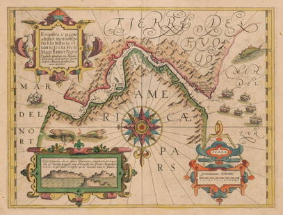
Sold2017Mercator: Strait of Magellan, Terra del Fuego, 1613Exquisita & magno aliquot mensium periculo Lustrata et iam retecta Freti Magellanici Facies . . . By: Gerard Mercator. Date: 1613 / Amsterdam. Dimensions: 14 x 18 inches (35.5 x 45.7 cm) This is an auSee Sold Price
Sold2016Strait of Magellan, Jodocus Hondius 1606-33Title: Freti Magellanici ac novi Freti vulgo Le Maire Subject: Strait of Magellan Maker: Jodocus Hondius Date: 1606-33, Amsterdam Size: 15.1 x 19.25 inches This is one of the best known early maps ofSee Sold Price
Sold2018Bellin: Hydrographic Chart of Havana BayCartographer: Bellin / Depot de la Marine Place/Date: Paris / 1762 Size: 22 1/4" x 16 1/4" Condition: wash color; overall age toning, repaired tears along edge of upper margin From the Hydrographie FrSee Sold Price
Sold2019Strait of Magellan Map[Strait of Magellan Map] , "Fretum Magellannicum", by Theodore De Bry, Frankfurt, 1601, copper engraved, depicting ships, natives, a penguin and a snail, 6 1/2 in. x 11 3/4 in., framed IMPORTANT: AllSee Sold Price
Sold2018Bellin: Hydrographic Chart of Havana BayMap: Carte Hydrographique de la Baye de la Havane. Cartographer: Bellin / Depot de la Marine Place & Date: Paris / 1762/1772 Size: 22 1/4" x 16 1/4" Condition: b&w; some nicks, splits and fraying alonSee Sold Price
Sold2023J. DE HONDT, COLOR MAP OF STRAITS OF MAGELLANJoost de Hondt (Belgian 1563-1612), "Freti Magel Lanici Ac Novi Freti Vulgo, Le Maitre Exactissima Delineatio", hand colored map of the Straits of Magellan, Le Maire Strait, Fire Lands and the southerSee Sold Price
Sold2023Lot of 3 Books by Rockwell Kent, Voyaging The Strait Of Magellan 1924, Salamina 1935, N by E 19351) Voyaging Southward From The Strait Of Magellan, with illustrations by the Author. Published by Halcyon House, New York 1924, Fourth Printing. Good condition. 2) Salamina, illustrated by the Author.See Sold Price
Sold2022Strait of Magellan from French Cook 1778Heading: (South America) Author: Bernard, Jean Frederic Title: Carte du Detroit de Magellan dans laquelle on an Insere les Observations et les Decouvertes du Capne. Byron, du Capne. Wallis, et du CapnSee Sold Price
Sold20201760 Bellin Map of Reunion -- Carte de l' Isle deTitle/Content of Map: 1760 Bellin Map of Reunion -- Carte de l' Isle de Bourbon autrefois Mascareigne Cartographer: J Bellin Year/Place: 1760 c., Paris Size: 8 X 9.4 in. This is an excellent map of thSee Sold Price
Sold20201760 Bellin Map of St Lawrence RiverEngraved map of Jacques Bellin circa 1752 entitled "Suite Du Cours Du Fleuve De St. Laurent Depuis Quebec jusqu u Lac Ontario" from his work "L'Historie Generale des voyages". Printed at Paris measureSee Sold Price
Sold20191760 Bellin Map of SouthEast India -- Theatre de LaTitle/Content of Map: 1760 Bellin Map of SouthEast India -- Theatre de La Guerre Sur la Coste De Coromandel Date: 1760, Paris Cartographer: J Bellin Size: 12.5 X 9.6 in. This is a very interesting andSee Sold Price
Sold20211760 Bellin Map of Coastal Vietnam to Hong Kong --Title: 1760 Bellin Map of Coastal Vietnam to Hong Kong -- Carte des Costes de Cochin Chine, Tunquin, et Partie de Celles de la Chine Cartographer: J Bellin Year / Place: 1760 c., Paris Map Dimension (See Sold Price
4 days LeftJasper52Détroit de Magellan. Strait of Magellan. Chile. BONNE 1790 old antique map$30
4 days LeftJasper52Détroit de Magellan. Strait of Magellan. Chile. BONNE 1788 old antique map$30
4 days LeftJasper52Extremité Meridionale de l'Amérique Tierra del Fuego Magellan Str BONNE 1788 map$35
Jun 08Leon GalleryPhilippe de Pretot, Etienne Andre (c. 1710 - 1787) and William Walton - Carte de Canal des Isles₱30,000
Jun 02Tremont AuctionsEdmund Howard, English ebonized bracket clock with composite brass dial, Chelsea, circa 1760. Two$300(1 bid)
Jun 02Tremont AuctionsQueen Anne walnut bonnet top high chest, Boston circa 1760. The broken arch crest with flame and urn$650(2 bids)
Crawford Family Auctions LLC44 pcs Vintage Fly Fishing Tools & Accessories Assortment. Magellan GPS 4000 XL. Shakespeare. See$21(2 bids)
93 Lots AwayHermann Historica GmbHA pair of Belgian silver-mounted flintlock pistols by Meunier of Liège, circa 1760See Sold Price
Jun 07Freeman's | HindmanBELLIN, Jacques-Nicolas. Carte Reduite de L'Ocean Oriental ou Mer Des Indies. Paris, 1757. Second$150
3 days LeftJasper521707 Schenk Dutch Provinces Chart with Leo Belgicus Map -- Tafel vande XVII Nederlandze Provincien,$240
4 days LeftJasper52Cartagène, Ste. Marthe et Venezuela'. Colombia. Cartagena. BELLIN 1754 map$80
3 days LeftJasper521886 Adams Chronological Chart of Civilizations -- A Chronological Chart of Ancient, Modern and$550
Jun 08Early American History Auctions1760 WILLIAM COWPER Signed Annuity of 1706 Payment British Exchequer Receipt; Anti-Slavery Advocate$1,200


![Strait of Magellan Map: [Strait of Magellan Map] , "Fretum Magellannicum", by Theodore De Bry, Frankfurt, 1601, copper engraved, depicting ships, natives, a penguin and a snail, 6 1/2 in. x 11 3/4 in., framed IMPORTANT: All](https://p1.liveauctioneers.com/268/150890/76180328_1_x.jpg?height=310&quality=70&version=1569336980)


