Sold2022JOHN TALLIS (1817-1876) A 'GOLD RUSH' MAP, "Mexico,JOHN TALLIS (1817-1876) A 'GOLD RUSH' MAP, "Mexico, California and Texas," LONDON, EDINBURGH AND DUBLIN, CIRCA 1851, hand-colored lithograph on paper, "The Illustrations by H. Warren & Engraved by J.See Sold Price
Sold2022(GOLD RUSH.) John Rapkin and others, for John Tallis. Mexico, California and Texas.(GOLD RUSH.) John Rapkin and others, for John Tallis. Mexico, California and Texas. Hand-colored engraved map of southwestern North America with illustrated vignettes including prospectors "Gold WashiSee Sold Price
Sold2022JOHN TALLIS (1817-1876) AN AMERICAN CIVIL WAR MAP, "United States," LONDON, CIRCA 1863,JOHN TALLIS (1817-1876) AN AMERICAN CIVIL WAR MAP, "United States," LONDON, CIRCA 1863, hand-colored lithograph on wove paper showing, "Federal, Non Slave Holding States (Red); Border, Slaveholding (BSee Sold Price
Sold2022[MAPS]. TALLIS, John (1817-1876). Polynesia, Islands in the...[MAPS]. TALLIS, John (1817-1876). Polynesia, Islands in the Pacific. London: John Tallis, [ca. 1850]. 4to (visible area: 264 x 351 mm). Hand-colored map. On white paper (3 vertical creases, map toned,See Sold Price
Sold20181850 Tallis map of Mexico California During Gold RushReserve Reduced! Title/Content of Map: 1850 Tallis map of Mexico California During Gold Rush and Texas -- Mexico, California and Texas Date: 1850, London Cartographer: J Tallis Size: 10 X 13 in. ThisSee Sold Price
Sold20211850 Tallis map of Mexico, California During Gold RushTitle: 1850 Tallis map of Mexico, California During Gold Rush and Texas -- Mexico, California and Texas Cartographer: J Tallis Year / Place: 1850, London Map Dimension (in.): 10 X 13 in. This is an ouSee Sold Price
Sold2021Tallis, John (Pub) 1852 Map. Mexico, California & TexasSteel Engraved Map with Original Outline Hand Color Published 1852-56 by John Tallis, London for "The Universal Pronouncing Dictionary" by Thomas Wright. Drawn & Engraved by John Rapkin. Centre fold aSee Sold Price
Sold2022(GOLD RUSH.) J.M. Atwood. Map of the United States, Canada, Mexico, Central America, and the West(GOLD RUSH.) J.M. Atwood. Map of the United States, Canada, Mexico, Central America, and the West India Islands with a Portion of Venezuela & New Granada; Showing the Routes Overland and by the IsthmuSee Sold Price
Sold2022MEXICO CALIFORNIA TEXAS. Gold rush district. TX Republic.TALLIS/RAPKIN 1851 mapTITLE/CONTENT OF MAP: 'Mexico, California & Texas' The map indicates the gold country of the California gold rush which had started 2 years earlier. The key indicates that "the newly discovered Gold dSee Sold Price
Sold2024Map of Mexico (California & Texas) by John Tallis, 1851Title/Content of Map: Map of Mexico (California & Texas) by John Tallis, 1851 Date Printed: 1851 Cartographer: John Tallis Material/Medium: Engraving Size: 11 x 14" John Tallis was a British map publiSee Sold Price
Sold2024Spanish North America. THOMSON. Texas, Mexico & Southwestern USA 1817 mapTitle: "Spanish North America". THOMSON. Texas, Mexico & Southwestern USA 1817 map Description: Spanish North America [northern part] by Drawn & engraved for John Thomson's "New General Atlas" (PublisSee Sold Price
2024Spanish North America. THOMSON. Texas, Mexico & Southwestern USA 1817 mapTITLE/CONTENT OF MAP: Spanish North America [northern part] A large map of Texas, Mexico and the American Southwest, published in Edinburgh by John Thompson, based on the explorations of Humboldt andSee Sold Price
Sold2023MEXICO CALIFORNIA TEXAS. Gold rush district. TX Republic.TALLIS/RAPKIN 1851 mapCAPTION PRINTED BELOW PICTURE: 'Mexico, California & Texas' The map indicates the gold country of the California gold rush which had started 2 years earlier. The key indicates that "the newly discoverSee Sold Price
Sold2023MEXICO CALIFORNIA TEXAS. Gold rush district. TX Republic.TALLIS/RAPKIN 1851 mapCAPTION PRINTED BELOW PICTURE: 'Mexico, California & Texas' The map indicates the gold country of the California gold rush which had started 2 years earlier. The key indicates that "the newly discoverSee Sold Price
Sold2024Mexico, California & Texas. CA Gold rush districts. Utah & NM Territory 1856 mapTitle: Mexico, California & Texas. CA Gold rush districts. Utah & NM Territory 1856 map Description: Mexico, California & Texas [inset: Guatimala or Central America] by Sidney Hall (1856). Antique atlSee Sold Price
Sold2018Audubon's son in the California Gold RushHeading: (Audubon, John Woodhouse) Author: Dentzel, Carl Schaefer Title: The Drawings of John Woodhouse Audubon: Illustrating his Adventures Through Mexico and California, 1849-1850 Place Published: SSee Sold Price
Sold2020Audubon's illustrations from the California Gold RushHeading: (Audubon, John Woodhouse) Author: Dentzel, Carl Schaefer Title: The Drawings of John Woodhouse Audubon: Illustrating his Adventures Through Mexico and California, 1849-1850 Place Published: SSee Sold Price
Sold2021GEORGE BURGESS 1853 CALIFORNIA GOLD MINING OPERATIONMokelunme River watercolor 10 x 14 inches. signed and dated. framed. 16 x 20 inches (overall) * Note: During the California Gold Rush, the Mokelumne was a major gold-producing stream. The first personSee Sold Price
Sold2022America.- Gold rush.- Hazlitt (William Carew) The Great Gold Fields of Cariboo; With an AuthenticAmerica.- Gold rush.- Hazlitt (William Carew) The Great Gold Fields of Cariboo; With an Authentic Description... of British Columbia and Vancouver Island, first edition, folding map frontispiece, addiSee Sold Price
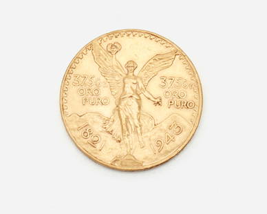
Sold2021A Mexican gold coin 50 pesosGold coin, Mexico 50 Pesos, 1821-1947, 37.5 Gr. Oro Puro 37mm Dia. 42 gramsSee Sold Price
Sold2015JOHN CALLCOTT HORSLEY OILJOHN CALLCOTT HORSLEY, (BRITISH, 1817-1903), OIL, H 55", W 43", "THE POETS THEME":Signed lower left. Elaborate pierced gold leaf and gesso frame. For a high resolution photoSee Sold Price
Sold2021Seven various gold coins1875, Netherlands, 10 Gulden, 23mm, 7 grams 1959, Great Britain, Elizabeth II, 22mm, 8 grams 1854, US $3 dollar, Indian Princess, 20mm, 6 grams 1877, Half Sovereign,19mm, 4 grams 1955, Mexico $5 pSee Sold Price
Sold2022RARE GENERAL ATLAS by M. CAREY 1817William Handy Jr. of Sandwich is also written on Turkey Map: Maps of the World and Quarters. Philadelphia, M. Carey 1817. hardcover paper bound, 17 x 11 inches Condition: Marginalia to flyleaf, waterSee Sold Price
Sold2022William Spratling (1900-1967, American)An 18k yellow gold and rosewood ring, circa 1951-1967, Third Design Period; Taxco, Mexico Stamped for William Spratling; Further stamped: 18K Designed as a bombe style ring centering a gold line setSee Sold Price
Jun 06Freeman's | HindmanLONDON, Jack. The Call of the Wild. FIRST EDITION, FIRST ISSUE. In the FIRST ISSUE BINDING.$400
2 days LeftCoins and Auctions Since 1994SS Central America California Gold Rush 1.68g Gold Nugget NGC$225(2 bids)
May 31Freeman's | Hindman[CALIFORNIA - EARLY PHOTOGRAPHY]. Whole plate daguerreotype of San Francisco, California. Circa$15,000


![[MAPS]. TALLIS, John (1817-1876). Polynesia, Islands in the...: [MAPS]. TALLIS, John (1817-1876). Polynesia, Islands in the Pacific. London: John Tallis, [ca. 1850]. 4to (visible area: 264 x 351 mm). Hand-colored map. On white paper (3 vertical creases, map toned,](https://p1.liveauctioneers.com/928/265343/138522758_1_x.jpg?height=310&quality=70&version=1666130009)


![Spanish North America. THOMSON. Texas, Mexico & Southwestern USA 1817 map: Title: "Spanish North America". THOMSON. Texas, Mexico & Southwestern USA 1817 map Description: Spanish North America [northern part] by Drawn & engraved for John Thomson's "New General Atlas" (Publis](https://p1.liveauctioneers.com/5584/314775/168780323_1_x.jpg?height=310&quality=70&version=1704837726)
![Spanish North America. THOMSON. Texas, Mexico & Southwestern USA 1817 map: TITLE/CONTENT OF MAP: Spanish North America [northern part] A large map of Texas, Mexico and the American Southwest, published in Edinburgh by John Thompson, based on the explorations of Humboldt and](https://p1.liveauctioneers.com/5584/320546/172232524_1_x.jpg?height=310&quality=70&version=1709072904)


![Mexico, California & Texas. CA Gold rush districts. Utah & NM Territory 1856 map: Title: Mexico, California & Texas. CA Gold rush districts. Utah & NM Territory 1856 map Description: Mexico, California & Texas [inset: Guatimala or Central America] by Sidney Hall (1856). Antique atl](https://p1.liveauctioneers.com/5584/314775/168780521_1_x.jpg?height=310&quality=70&version=1704837726)


![[GOLD RUSH] 49er's Brazil Letter (1 of 3)](https://p1.liveauctioneers.com/7226/322253/173251519_1_x.jpg?height=282&quality=70&version=1710004847)


![Mining Operation, Gold Rush Era [Ambrotype] (1 of 1)](https://p1.liveauctioneers.com/7226/322253/173251709_1_x.jpg?height=282&quality=70&version=1710004847)


![[CALIFORNIA - EARLY PHOTOGRAPHY]. Whole plate daguerreotype of San Francisco, California. Circa (1 of 7)](https://p1.liveauctioneers.com/197/329785/177758569_1_x.jpg?height=282&quality=70&version=1715625218)

