Sold2023James Wyld, 1853 Map of ChinaTitle/Content of Map: James Wyld, 1853 Map of ChinaDate Printed: 1853Cartographer: James WyldMaterial/Medium: paper. Steel engravedSize: 82cm x 63.7cmProvenance: Bought from long time Asian map collecSee Sold Price
Sold2022(UNITED STATES - REPUBLIC OF TEXAS.) James Wyld. Map of the United States and the Provinces of Upper(UNITED STATES - REPUBLIC OF TEXAS.) James Wyld. Map of the United States and the Provinces of Upper & Lower Canada, New Brunswick, and Nova Scotia, Compiled from the Latest Surveys and Other AuthentiSee Sold Price
Sold2016James Wyld, "Map of the West India and Bahama IslandsJames Wyld, "Map of the West India and Bahama Islands with the Adjacent Coasts of Yucatan, ……..". image size 21" x 30 1/2" vertical crease, no stains apparent. Framed and matted. A very detailed mSee Sold Price
Sold20171830 James Wyld Map of Persia and Caubul1830 James Wyld Map of Persia and Caubul. Hand-colored, detailed steel-engraved map of Persia and Caubul (Afghanistan) with original hand coloring. Engraved by Stockley. Attractive piano key border. 9See Sold Price
Sold2019India.- Wyld (James) Map of the Countries betweenIndia.- Wyld (James) Map of the Countries between England and India Designed to shew the Over-Land and Sea Routes to the East..., map of Europe and Asia between Britain and India, with the MediterraneSee Sold Price
Sold2019James Wyld (1812-1887, London), "Map of North AmericaJames Wyld (1812-1887, London), "Map of North America Exhibiting Recent Discoveries Geographical and Nautical," hand colored atlas page, H.- 23 in., W.- 17 in.See Sold Price
Sold2019Barclay, James 1809 Antique Map. ChinaOutline Hand Coloured Copper Engraved Map Published 1809, Leeds for "Barclay's Complete and Universal Dictionary of the English Language..." by the Rev. James Barclay. Paper Size: 10 x 8 inch (26 x 20See Sold Price
Sold2023Barclay, James 1808 Antique Map. China from the most recent AuthoritiesCopper Engraved Map Published 1806, London for "Barclay's Complete and Universal English Dictionary" by the Rev. James Barclay. Paper Size: 10 x 8 inch (26 x 21cm) Good ConditionSee Sold Price
Sold2021[MAPS] WYLD, JAMES. A LOT OF 20 MAPS[MAPS] WYLD, JAMES. A lot of 20 maps, including: [WYLD, James] A lot of 20 pieces, Engraved title and 19 engraved hand coloured maps. Sold as acollection. London: Thomas Tegg, c.1826- 1860. Approx. 20See Sold Price
Sold2018Wyld, James C1850's Map of Turkey & Ottoman Empire"European Dominions of the Ottomans or Turkey in Europe" Lithograph Map Published C1850's by James Wyld, London. Originally Copper Engraved, this a Lithograph Map by the same Publishers. Outline handSee Sold Price
Sold2023ATLASES AND POCKET MAPS. 3 PIECES TOGETHERATLASES AND POCKET MAPS. A lot of 3 pieces sold together. Generally good condition, various imperfections. Including: Wyld, James. WORLD MAP. London: James Wyld, n.d. 12mo. Folding map, mounted to cloSee Sold Price
Sold2024Wyld, James Set of maps - Middle East, Greece and TurkeySet of maps - Middle East, Greece and Turkey Map of the Ottoman Dominions in Asia, with the Adjacent Frontiers of the Russian and Persian Empires, 1833. 53.5 x 73cm;European Dominions of the Ottomans.See Sold Price
Sold2022AN ANTIQUE PRINTED MAP 'CHINA' BY J. WYLD / J. THOMSON, London 1825. Copperplate Original colour. AnAN ANTIQUE PRINTED MAP 'CHINA' BY J. WYLD / J. THOMSON, London 1825. Copperplate Original colour. An attractive nineteenth-century map of China with a vignette view of a Chinese village at lower rightSee Sold Price
Sold2022CHINA - SHANGHAI WATERS (THOMAS JAMES) Map of the Country Around Shanghai. Compiled from the Bes...CHINA - SHANGHAI WATERS (THOMAS JAMES) Map of the Country Around Shanghai. Compiled from the Best Authorities with Numerous Additions from Actual Survey, large lithographed map, dissected into 20 secSee Sold Price
Sold2022Wyld, James 1840 LG Hand Col Map. West Africa"Map of Part of the Western Coast of Africa Extending from the Isles de Loss to Sherboro Island" Showing Sierra Leone and area. Hand Colored Steel Engraved Map By Surgeon O'Beirne and Major Laing. PubSee Sold Price
Sold20201860 Map of ItalyAuthor: Stockley Title: 1860 Map of Italy Medium: Ink on Paper Dimensions: 9"X10.5" Description: Map of Italy and Switzerland dated 1860. Engraved by James Stockley. Published by James Wyld engraver tSee Sold Price
Sold20201860 Map of the United StatesAuthor: Stockley Title: 1860 Map of the United States Medium: Ink on Paper Dimensions: 10.5"X9" Map of the United States dated 1860. Engraved by James Stockley. Published by James Wyld engraver to QueSee Sold Price
Sold20201860 Map of ScotlandAuthor: Stockley Title: 1860 Map of Scotland Medium: Ink on Paper Dimensions: 9"X10.5" Description: Map of Scotland dated 1860. Engraved by James Stockley. Published by James Wyld engraver to Queen ViSee Sold Price
Sold20201860 Map of IrelandAuthor: Stockley Title: 1860 Map of Ireland Medium: Ink on Paper Dimensions: 9"X10.5" Description: Map of Ireland dated 1860. Engraved by James Stockley. Published by James Wyld engraver to Queen VictSee Sold Price
Sold20201860 Map of EgyptAuthor: Stockley Title: 1860 Map of Egypt Medium: Ink on Paper Dimensions: 9"X10.5" Description: Map of Egypt dated 1860. Engraved by James Stockley. Published by James Wyld engraver to Queen VictoriaSee Sold Price
Sold20211860 Russia and Poland MapAuthor: Stockley Title: 1860 Russia and Poland Map Medium: Ink on Paper Dimenions: 9"X10.5" Description: Map of Russia and Poland dated 1860. Engraved by James Stockley. Published by James Wyld engravSee Sold Price
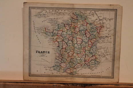
Sold20211860 Map of FranceAuthor: Stockley Title: 1860 Map of France Medium: Ink on Paper Dimensions: 10.5"X9" Map of France dated 1860. Engraved by James Stockley. Published by James Wyld engraver to Queen Victoria in CharingSee Sold Price
Sold2018Wyld, James C1840 Group of 4 Hand Coloured MapsIncl Spain/Portugal, Syria, Asia and Turkey in Asia. Hand Coloured Steel Engraved Map Published C1840, London for "Atlas of Modern Geography" by James Wyld. Centre fold as published. Paper Size: 11 xSee Sold Price
Sold2020Genuine Regal China (Handcrafted)Title/Content of Map: Genuine Regal China (Handcrafted)James B. Beam Distilling Co. Date: 1980 Beam months 100 old. Kentucky straight bourbon whiskey bottled by James B. Beam Distilling Co. Clermont-BSee Sold Price
Jun 08Early American History Auctions1853 Map, Basin of the St. Lawrence, by T. Keefer showing Natural + Artificial North American Routes$220
Jun 08Early American History Auctions1853 Map of Portion of British North America and Gulf of St. Lawrence, by Henry Perley$260
Jun 08Early American History Auctions1853 Specialized Map, Railroads in the United States in Operation and Progress... Treasury Deptment$200(1 bid)
6 days LeftPropstoreBIG TROUBLE IN LITTLE CHINA (1986) - James Hong, Peter Kwong, Donald Li, Jim Lau and Others Autograp£250
Jun 01Ripley AuctionsBen Ali Haggin, New York (1882 - 1951), Portrait of Betty Smith, c. 1920, oil on canvas, 29 1/2"H x$1,000
17 hrs LeftTrillium Antique Prints & Rare BooksSanson - Map of the Philippines and Ladrones Islands$75
17 hrs LeftTrillium Antique Prints & Rare BooksSanson - Map of the Sunda Islands, Sumatra, Java, & Borneo$75
Jun 01Trillium Antique Prints & Rare BooksSanson - Map of Florida (encompassing most of Southeast North America)$75


![[MAPS] WYLD, JAMES. A LOT OF 20 MAPS: [MAPS] WYLD, JAMES. A lot of 20 maps, including: [WYLD, James] A lot of 20 pieces, Engraved title and 19 engraved hand coloured maps. Sold as acollection. London: Thomas Tegg, c.1826- 1860. Approx. 20](https://p1.liveauctioneers.com/1124/208511/106199218_1_x.jpg?height=310&quality=70&version=1624388585)


![[India] Rennell, James, Major (1 of 2)](https://p1.liveauctioneers.com/94/330664/178342480_1_x.jpg?height=282&quality=70&version=1716466933)


