Sold20171830 James Wyld Map of Persia and Caubul1830 James Wyld Map of Persia and Caubul. Hand-colored, detailed steel-engraved map of Persia and Caubul (Afghanistan) with original hand coloring. Engraved by Stockley. Attractive piano key border. 9See Sold Price
Sold2017Map of Persia, 1830Map: Persia Maker: Longman, Rees, Orme, Brown and Green, Sydney Hall Date: 1830 Size: Folio, 19.75 inches high x 16.25 inches wide Polar projection. Persia with Turkestan, Afghanistan ("Caubul"), BeloSee Sold Price
Sold2022(UNITED STATES - REPUBLIC OF TEXAS.) James Wyld. Map of the United States and the Provinces of Upper(UNITED STATES - REPUBLIC OF TEXAS.) James Wyld. Map of the United States and the Provinces of Upper & Lower Canada, New Brunswick, and Nova Scotia, Compiled from the Latest Surveys and Other AuthentiSee Sold Price
Sold2016James Wyld, "Map of the West India and Bahama IslandsJames Wyld, "Map of the West India and Bahama Islands with the Adjacent Coasts of Yucatan, ……..". image size 21" x 30 1/2" vertical crease, no stains apparent. Framed and matted. A very detailed mSee Sold Price
Sold2023James Wyld, 1853 Map of ChinaTitle/Content of Map: James Wyld, 1853 Map of ChinaDate Printed: 1853Cartographer: James WyldMaterial/Medium: paper. Steel engravedSize: 82cm x 63.7cmProvenance: Bought from long time Asian map collecSee Sold Price
Sold2019India.- Wyld (James) Map of the Countries betweenIndia.- Wyld (James) Map of the Countries between England and India Designed to shew the Over-Land and Sea Routes to the East..., map of Europe and Asia between Britain and India, with the MediterraneSee Sold Price
Sold2019James Wyld (1812-1887, London), "Map of North AmericaJames Wyld (1812-1887, London), "Map of North America Exhibiting Recent Discoveries Geographical and Nautical," hand colored atlas page, H.- 23 in., W.- 17 in.See Sold Price
Sold2021[MAPS] WYLD, JAMES. A LOT OF 20 MAPS[MAPS] WYLD, JAMES. A lot of 20 maps, including: [WYLD, James] A lot of 20 pieces, Engraved title and 19 engraved hand coloured maps. Sold as acollection. London: Thomas Tegg, c.1826- 1860. Approx. 20See Sold Price
Sold2018Wyld, James C1850's Map of Turkey & Ottoman Empire"European Dominions of the Ottomans or Turkey in Europe" Lithograph Map Published C1850's by James Wyld, London. Originally Copper Engraved, this a Lithograph Map by the same Publishers. Outline handSee Sold Price
Sold2023ATLASES AND POCKET MAPS. 3 PIECES TOGETHERATLASES AND POCKET MAPS. A lot of 3 pieces sold together. Generally good condition, various imperfections. Including: Wyld, James. WORLD MAP. London: James Wyld, n.d. 12mo. Folding map, mounted to cloSee Sold Price
Sold2024Wyld, James Set of maps - Middle East, Greece and TurkeySet of maps - Middle East, Greece and Turkey Map of the Ottoman Dominions in Asia, with the Adjacent Frontiers of the Russian and Persian Empires, 1833. 53.5 x 73cm;European Dominions of the Ottomans.See Sold Price
Sold2017Sydney Hall: Map of Persia, 1830Map of Persia. Longman, Orme & Co., Hall, Sidney, 1830, London. Folio - 16.30 H x 20.00 W Inches, Scarce atlas map with beautiful color. Covers Iraq, Iran, Afghanistan region. Dry with margin repair.See Sold Price
Sold2017Sidney Hall: Map of Persia, 1830Map: Persia. Maker: Longman, Rees, Orme, Brown and Green, Hall, Sidney Publication Date: 1830 Publisher: Longman, Rees, Orme, Brown and Green Size: Folio – 19.75 H x 16.25 W Inches Polar projection.See Sold Price
Sold2015Victor Lavasseur. Map of Persia. 1830.Print of hand colored steel engraving titled Perse Kaboul Herat Beloutchistan“.Author Victor Lavasseur.Engraved by unknown.From Atlas classique universel de Geographie anciene et moderne“ by VictoSee Sold Price
Sold2022Wyld, James 1840 LG Hand Col Map. West Africa"Map of Part of the Western Coast of Africa Extending from the Isles de Loss to Sherboro Island" Showing Sierra Leone and area. Hand Colored Steel Engraved Map By Surgeon O'Beirne and Major Laing. PubSee Sold Price
Sold20201860 Map of ItalyAuthor: Stockley Title: 1860 Map of Italy Medium: Ink on Paper Dimensions: 9"X10.5" Description: Map of Italy and Switzerland dated 1860. Engraved by James Stockley. Published by James Wyld engraver tSee Sold Price
Sold20201860 Map of the United StatesAuthor: Stockley Title: 1860 Map of the United States Medium: Ink on Paper Dimensions: 10.5"X9" Map of the United States dated 1860. Engraved by James Stockley. Published by James Wyld engraver to QueSee Sold Price
Sold20201860 Map of ScotlandAuthor: Stockley Title: 1860 Map of Scotland Medium: Ink on Paper Dimensions: 9"X10.5" Description: Map of Scotland dated 1860. Engraved by James Stockley. Published by James Wyld engraver to Queen ViSee Sold Price
Sold20201860 Map of IrelandAuthor: Stockley Title: 1860 Map of Ireland Medium: Ink on Paper Dimensions: 9"X10.5" Description: Map of Ireland dated 1860. Engraved by James Stockley. Published by James Wyld engraver to Queen VictSee Sold Price
Sold20201860 Map of EgyptAuthor: Stockley Title: 1860 Map of Egypt Medium: Ink on Paper Dimensions: 9"X10.5" Description: Map of Egypt dated 1860. Engraved by James Stockley. Published by James Wyld engraver to Queen VictoriaSee Sold Price
Sold20211860 Russia and Poland MapAuthor: Stockley Title: 1860 Russia and Poland Map Medium: Ink on Paper Dimenions: 9"X10.5" Description: Map of Russia and Poland dated 1860. Engraved by James Stockley. Published by James Wyld engravSee Sold Price
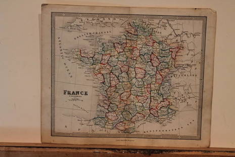
Sold20211860 Map of FranceAuthor: Stockley Title: 1860 Map of France Medium: Ink on Paper Dimensions: 10.5"X9" Map of France dated 1860. Engraved by James Stockley. Published by James Wyld engraver to Queen Victoria in CharingSee Sold Price
Sold2018Wyld, James C1840 Group of 4 Hand Coloured MapsIncl Spain/Portugal, Syria, Asia and Turkey in Asia. Hand Coloured Steel Engraved Map Published C1840, London for "Atlas of Modern Geography" by James Wyld. Centre fold as published. Paper Size: 11 xSee Sold Price
Sold2021Encyclo. Britannica C1830 Pair of Maps. Persia &Steel Engraved Maps Published 1830-42, Edinburgh for "Encyclopedia Britannica" Seventh Edition. Centre fold as issued. Paper Size: 16 x 11 inch (40 x 28cm) Very minor toning, otherwise fineSee Sold Price
5 days LeftNY Elizabeth ERNEST FLOYER'S 1882 UNEXPLORED BALUCHISTAN ANTIQUE MAP ILLUSTRATED IN ENGLISH$50
6 days LeftFreeman's | Hindman[CIVIL WAR]. Possibly by Andrew Joseph RUSSELL (1830-1902), or Egbert Guy FOWX (b. 1821),$500
Jun 02Schilb Antiquarian Rare Books1897 History of British Empire England Scotland Canada James II MAPS India 6v$6(4 bids)
Jun 07Freeman's | HindmanCOOK, James, Captain. -- [SECOND VOYAGE]. A Voyage towards the South Pole, and Round the World...$1,500
Jun 01Trillium Antique Prints & Rare BooksJohn James Audubon's Birds of America - 7 Volume set with 500 Originally Hand-colored Lithographs,$30,000


![[MAPS] WYLD, JAMES. A LOT OF 20 MAPS: [MAPS] WYLD, JAMES. A lot of 20 maps, including: [WYLD, James] A lot of 20 pieces, Engraved title and 19 engraved hand coloured maps. Sold as acollection. London: Thomas Tegg, c.1826- 1860. Approx. 20](https://p1.liveauctioneers.com/1124/208511/106199218_1_x.jpg?height=310&quality=70&version=1624388585)


![[CIVIL WAR]. Possibly by Andrew Joseph RUSSELL (1830-1902), or Egbert Guy FOWX (b. 1821), (1 of 2)](https://p1.liveauctioneers.com/197/329785/177758329_1_x.jpg?height=282&quality=70&version=1715625218)


![COOK, James, Captain. -- [SECOND VOYAGE]. A Voyage towards the South Pole, and Round the World... (1 of 2)](https://p1.liveauctioneers.com/197/329395/177650491_1_x.jpg?height=282&quality=70&version=1715364962)


