Sold2022EUROPE showing daylight hours at summer equinox. Sunrise-sunset. MALLET 1683 mapTITLE OF THE MAP: 'Europe' (De la Sphere) The scale along the right hand edge shows the number of daylight hours at the summer equinox (the longest day of the year) at differing latitudes DATE PRINTEDSee Sold Price
Sold2017Mallet: Antique Map of Europe at Summer Equinox, 1683Title/Content of the Map: 'Europe' The scale along the right hand edge shows the number of daylight hours at the summer equinox (the longest day of the year) at differing latitudes. Sunrise-sunset. DaSee Sold Price
Sold2024SUNSET GASOLINE 15" SINGLE GLOBE LENS W/ SHIPPING CRATE DISPLAY.AGS CERTIFIED #11167. Single 15" Globe Lens. Rare C. 1920's Single Lens for Sunset Gasoline showing iconic Sunset graphic with "Sunrise Motor Oils" banner at the lower. CONDITION: Lens is original andSee Sold Price
Sold2019An Egyptian Revival sunrise/sunset setteeAn Egyptian Revival mother of pearl inlaid sunrise/sunset settee possibly Cairo early 20th century height of back 38 1/2in (98cm); height of seat 20in (51cm); width of seat 50in (127cm); depth of seatSee Sold Price
Sold2023Rare 1925 Map of The Town and Harbor of Nantucket by Phillip L. HallRare 1925 Map of The Town and Harbor of Nantucket by Phillip L. Hall, whimsical map showing the town, harbor, ships, aircraft, and prominent landmarks of the island. Overall 23 in. x 15 in.See Sold Price
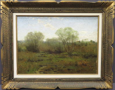
Sold2024William Bliss Baker, (American, 1859-1887)Oil on canvas showing a summer pastoral scene. Signed l/l, image size: 16’’x22’’, (Frame size: 23’’x29’’). Minor paint flaking l/r.See Sold Price
Sold1919 Map of European Russia1919 Map of European Russia: Map showing the lines held by the Soviet Army on June 5th 1919, done by N.R.E.F. Mapping Section, in folded condition, size 40 cm x 42 cm.See Sold Price
Sold2021Alexandra Nechita - Summer in EuropeArtist: Alexandra Nechita Title: Summer in Europe Year: 1996 Dimensions: 36in. by 47in. Edition: From the rare limited edition of 250 Medium: Original serigraph on canvas</See Sold Price
Sold2020[SEUTTER, M] 52 Maps of Europe sold togetherSEUTTER,M. 52 Maps of Europe sold together. ca. 1700. Includes. Europa ** Flandria ** Hanoniae ** Belgii **Luxemburg ** Dauphine Five Delpinatus ** Parmensis Et Placentinus ** Transylvaniae ** DucatusSee Sold Price
Sold2021DEREK BOSHIER (British b. 1937) A PAINTING, "BetweenDEREK BOSHIER (British b. 1937) A PAINTING, "Between Sunset and Sunrise, Houston," 1980, oil on canvas, signed verso. 42 1/8" x 55 1/8" Note: Derek Boshier's "Texas paintings" completed during the 198See Sold Price
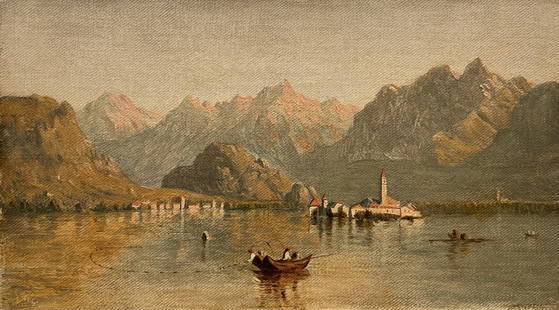
Sold2023Hudson River School Original Sanford Robinson Gifford Lago Maggiore Oil Painting Of ItalySanford Robinson Gifford (1823-1880) A Sunset or Sunrise scene of Lago Maggiore. An original work by the noted Hudson River School artist. Oil on canvas. Signed lower left. 6 x 10 1/2 inches. From anSee Sold Price
Sold2023Rare Original Antique Union Square Poster in Mid Summer NYC with Celebrities c1900Rare Antique Original Union Square lithograph poster in mid-summer NYC showing celebrities including L Frank Baum, creator of "The Wizard of Oz", In his 20's Baum wished to be an actor and trained atSee Sold Price
Sold2023Historical English Horse Painting, possibly by John Ferneley, Sr.Oil on canvas equestrian portrait depicting a dapple-grey hunter in a hilly landscape set against a cloudy sunset or sunrise sky. Signed lower left, "John Ferneley," (British, 1782-1860). HandwritingSee Sold Price
Sold20241719 Map of Colonial era North America, by Sanson - JaillotTitle: 1719 Map of Colonial era North America, by Sanson - Jaillot Date/Period: 1719 Materials: Copperplate engraved Size: 25 1/2 x 18” This map is a rare and valuable map of history, showing NoSee Sold Price
Sold2015Jansson (Jan) - [Atlas Novus: Germany],single vol. lacking title, 106 mostly regional maps of Germany and northern Europe, but also including a general map of Germany, and classical maps of both Germany and Scandinavia, and several city plSee Sold Price
Sold2024Rolex GMT Master Ref 1675 - PepsiAuthentic Rolex GMT Master Pepsi WristwatchYear 1974 Reference 1675 Serial 3115136 Original Mark 2 Matte Black Dial Acrylic Crystal The hand set is original only showing some wear on the second-hour hSee Sold Price
Sold2016EXCEPTIONAL 18TH C. DUTCH MUSICAL TALL CLOCK, LOGGEc. 1750, sgn. on dial: Johannes Logge, Amsterdam dial with moon-phase indicates hours, minutes, seconds, day of week (showing engraved astrological symbols and figures), and date; six pairs of tunes pSee Sold Price
Sold20151845 MITCHELL'S REFERENCE & DISTANCE WALL MAP U.S.SHOWING MITCHELL'S 1845 REFERENCE AND DISTANCE WALL MAP OF THE UNITED STATES WITH GENERAL MAP OF THE US WITH CONTIGUOUS BRITISH AND MEXICAN POSSESSIONS.PHILADELPHIA : S. AUGUSTUS MITCHELL COPPER-ENGRASee Sold Price
Sold2022An Enameled 'Pine, Scholar, Poem' Mallet VaseAn Enameled 'Pine, Scholar, Poem' Mallet Vase. Supported on a subtly splayed foot. Chinese Qing Dynasty. Yongzheng Six-Character Mark. Size:31.6cmx12.5cmSee Sold Price
2024An exquisite white jade auspicious animal signAn exquisite white jade auspicious animal brand, the jade shows delicate, warm and lustrous qualities. The craftsmanship is flawless, the design is exquisite, and the carvings are exquisite, showing eSee Sold Price
Sold2020KING STEPHEN: (1947- )KING STEPHEN: (1947- ) American Author. Signed 10 x 8 photograph showing the writer outdoors, seated in a full length pose, during a filming. Boldly signed by King in blue ink to a clear area of the iSee Sold Price
Sold2017De Wit Portolan Sea Chart of EuropeTotius Europae Victoria... Frederic De Wit (1630-1706). Engraved map with original hand color. Amsterdam, 1675. 20 x 35 1/2 inches sheet, 27 1/2 x 43 inches framed. “The most striking and decorativeSee Sold Price
Sold2017First printed plan of New Haven, showing Yale CollegeA plan of the town of New Haven : with all the buildings in 1748...William Lyon (fl. c. 1800-1806). Engraved map. New Haven: T. Kensett, 1806. 28 1/4 x 20 1/2 inches sheet. The Kensett map is the firsSee Sold Price
Sold2024CHINA & JAPAN showing Opium Wars battlefields & dates. JOHNSTON 1913 old mapCAPTION PRINTED BELOW PICTURE: 'China and Japan // Islands of Japan' DATE PRINTED: 1913 IMAGE SIZE: Approx 34.5 x 43.5cm, 13.5 x 17.25 inches (Large); Please note that this is a folding map. TYPE: AntSee Sold Price
Jun 18DOYLE Auctioneers & AppraisersSet of Twelve Satirical Anthropomorphic Maps of Europe$400(1 bid)
3 hrs LeftEmanon Auctions and Estate SalesLot of vintage Olympia EC 7000 register, Desert Storm card and map set, Souther Pacific vintage$5
3 days LeftFreeman's | Hindman[MAP]. ORTELIUS, Abraham. Presbiteri Iohannis, sive, Abissinorum Imperii Descriptio. 1592.$200
7 days LeftBill Hood & Sons Art & Antique AuctionsR.A. MCLENDON FLORIDA HIGHWAYMEN, oil on canvas, Sunset/Red Fire Sky River Scene, Signed lower$350(3 bids)


![[SEUTTER, M] 52 Maps of Europe sold together: SEUTTER,M. 52 Maps of Europe sold together. ca. 1700. Includes. Europa ** Flandria ** Hanoniae ** Belgii **Luxemburg ** Dauphine Five Delpinatus ** Parmensis Et Placentinus ** Transylvaniae ** Ducatus](https://p1.liveauctioneers.com/1124/187577/94368891_1_x.jpg?height=310&quality=70&version=1607095126)


![Jansson (Jan) - [Atlas Novus: Germany],: single vol. lacking title, 106 mostly regional maps of Germany and northern Europe, but also including a general map of Germany, and classical maps of both Germany and Scandinavia, and several city pl](https://p1.liveauctioneers.com/410/80717/41962763_1_x.jpg?height=310&quality=70&version=1445353131)


![[MAP]. ORTELIUS, Abraham. Romani Imperii Imago. 1592. (1 of 2)](https://p1.liveauctioneers.com/197/329395/177650537_1_x.jpg?height=282&quality=70&version=1715364962)


![[MAP]. SPEED, John. A New Mappe of the Romane Empire. 1676. (1 of 2)](https://p1.liveauctioneers.com/197/329395/177650541_1_x.jpg?height=282&quality=70&version=1715364962)


![[MAP]. ORTELIUS, Abraham. Presbiteri Iohannis, sive, Abissinorum Imperii Descriptio. 1592. (1 of 2)](https://p1.liveauctioneers.com/197/329395/177650536_1_x.jpg?height=282&quality=70&version=1715364962)


