Sold20241719 Map of Colonial era North America, by Sanson - JaillotTitle: 1719 Map of Colonial era North America, by Sanson - Jaillot Date/Period: 1719 Materials: Copperplate engraved Size: 25 1/2 x 18” This map is a rare and valuable map of history, showing NoSee Sold Price
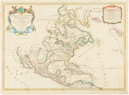
Sold2015Map of North America 1719Heading: (North America) Author: Sanson, Nicolas/ Hubert Jaillot Title: Amerique Septentrionale divisée en ses Principales Parties, ou sont distingués les uns des autres les Estats suivant quils appSee Sold Price
Sold2021Colonial era North America with the rarely seen ‘seaTitle: Colonial era North America with the rarely seen ‘sea of the west’, 1780, by J. de la Porte. Paris Date/Period: 1780 Materials: Copperplate engraved Size: 9x7'' By far the most fascSee Sold Price
Sold2023 [MAPS - COLONIAL NORTH AMERICA]. VAUGONDY, Gilles Robert de...[MAPS - COLONIAL NORTH AMERICA]. VAUGONDY, Gilles Robert de (1688-1766). Partie de l'Amerique Septentrionale qui Compred le Cours de l'Ohio… Paris, 1755. Large hand-colored engraved map (520 x 6See Sold Price
Sold2024Lotter Map Of Colonial North America In French By Matthew AlbertMap is roughly 1760's, Site 24.5" x 20.25"See Sold Price
Sold2020KITCHIN, THOMAS. A New Map of the British Empire inKITCHIN, THOMAS. A New Map of the British Empire in Nth. America. Hand-colored engraved folding map of colonial North America from George Millar's New and Universal System of Geography. 13½x15See Sold Price
Sold2020MOLL, HERMAN. A Map of New France Containing Canada,MOLL, HERMAN. A Map of New France Containing Canada, Louisiana &c. in Nth America. Hand-colored engraved map of colonial North America. 7¾x10¾ inches sheet size, ample margins; mounted to foSee Sold Price
Sold2022(AMERICAN SOUTHEAST.) Herman Moll. Carolina.(AMERICAN SOUTHEAST.) Herman Moll. Carolina. Engraved map of colonial North America from St. Augustine to the Chesapeake Bay. 8½x12 inches sheet size, ample margins; minor closure at upper edge,See Sold Price
Sold2022(CARIBBEAN.) Emanuel Bowen. A New and Accurate Chart of the West Indies with the Adjacent Coasts of(CARIBBEAN.) Emanuel Bowen. A New and Accurate Chart of the West Indies with the Adjacent Coasts of North and South America. Double-page engraved map of colonial North America and the western AtlanticSee Sold Price
Sold20222 maps, colonial New York & North America, New York2 maps, colonial New York & North America, New York City, North River, Hudson Valley, "for D1, Valentine's Manual, for 1860, 13' by 10" & map of North America, United States, with various illustrationSee Sold Price
Sold2020Jacques Chiquet North America Map 1719 CaliforniaJacques Chiquet (1673-1721), "L'Amerique Septentrionale qui fait partie des Indes Occidentales," Paris, 1719. This excellent hand colored map of North America includes a depiction of California as anSee Sold Price
Sold2023Civil War era map of North America from S. A. Mitchell Jr.Wonderful map of the North American continent with 1860 date but published in the 1863 Mitchell New General Atlas. Shows the United States at the height of the Civil War. Depicts the North American coSee Sold Price
Sold20221755 Map of North America by De VaugondyHistoric Maps 1755 French & Indian War Era Map of North America by De Vaugondy 1755-Dated French & Indian War Era, Large Hand-Colored Map titled, "PARTIE DE L'AMERIQUE SEPTENTRIONALE, QUI COMPREND LESee Sold Price
Sold2022AN AMERICAN CIVIL WAR ERA MAP, "United States of North America (Eastern & Central)," LONDON,AN AMERICAN CIVIL WAR ERA MAP, "United States of North America (Eastern & Central)," LONDON, 1861-1873, THEODORE ETTLING (b. 1823), hand colored lithograph on paper, by T. Ettling, published by CasselSee Sold Price
Sold2017Jaillot: Antique Map of North America, 1696Map: 1696 Jaillot Map of North America (California as an Island) -- Amerique Septentrionale Divisee en ses Principales Parties Date Printed: 1696 Amsterdam Cartographer: H. Jaillot Size: 19.3 x 23 in.See Sold Price
Sold2022(COLONIAL NORTH AMERICA.) John Senex, Charles Price, and John Maxwell. North America.(COLONIAL NORTH AMERICA.) John Senex, Charles Price, and John Maxwell. North America. Large engraved map of North America on two sheets of laid paper joined. 39x26¾ inches overall, wide margins;See Sold Price
Sold2022(COLONIAL NORTH AMERICA.) Jean-Baptiste Bourguignon d'Anville. Canada Louisiane et Terres Angloises.(COLONIAL NORTH AMERICA.) Jean-Baptiste Bourguignon d'Anville. Canada Louisiane et Terres Angloises. Large hand-colored engraved wall map of eastern North America. 4 sheets trimmed and joined, 37x45&#See Sold Price
Sold2022(COLONIAL NORTH AMERICA.) Group of 3 small format 18th-century engraved maps.(COLONIAL NORTH AMERICA.) Group of 3 small format 18th-century engraved maps. London, vd - The Royal Magazine; G. Rollos, engraver. A New and Accurate Map of the Present Seat of War in North America.See Sold Price
Sold2022(COLONIAL NORTH AMERICA.) Richard William Seale. A Map of North America with the European(COLONIAL NORTH AMERICA.) Richard William Seale. A Map of North America with the European Settlements & Whatever Else is Remarkable in ye West Indies. Double-page engraved map of North America featuriSee Sold Price
Sold2020Hubert Jaillot Map South America 1719Hubert Jaillot (1632-1712), "Amerique Meridionale divisee en ses pricipales Parties ou sont distingues les uns des autres les Estats suivant qu'ils appartiennent presentement aux Francois, Castillans,See Sold Price
Sold2022Southern colonial era America. Carolina’s to Florida, 1780/81 scarce map by J. B. NolinTitle: Southern colonial era America. Carolina’s to Florida, 1780/81 scarce map by J. B. Nolin Date/Period: 1780/81 Materials: Hand colored copper plate engraved Size: 14 1/2 x 10 1/4” ShoSee Sold Price
Sold202119th C. Spanish Colonial Texas Brass Water PitcherNorth America, United States, Texas, late Spanish Colonial Period, ca. 19th century CE. A brass pitcher or water jug discovered in Texas that likely belonged to a Spanish Colonial era settler. The pieSee Sold Price
Sold2018AFTER NICOLAS SANSON (FRENCH, 1600-1667) MAP OF NORTHAFTER NICOLAS SANSON (FRENCH, 1600-1667) MAP OF NORTH AMERICA, hand-colored, on laid paper, title in cartouche to upper left corner lettered "NORTH AMERICA / Divided into it's Principall Parts / whereSee Sold Price
Sold2016Hubert Jaillot. Amerique Septentrionale diviséeHubert Jaillot. Amerique Septentrionale divisée en ses principales parties<See Sold Price
2 days LeftPotter & Potter AuctionsSTORM, Mark. Official Texas Brags Map of North America. 194...$200(1 bid)
13 hrs LeftUniversity ArchivesDeclaration of Independence, Very Early British Publ. in Gentleman's Magazine & Rare Map$1,000
May 26GOLDEN SUN AUCTIONS, Inc. (formerly Appraisal & Estate Sale Specialists, Inc.)William Guthries British Colonies of North America Map Circa 1800$40
13 hrs LeftUniversity ArchivesScarce Early Printing: "An Account of the European Settlement in America in 6 Parts..."$100
Jun 07Freeman's | HindmanHOMANN, Johann Baptist. Amplissimae Regionis Mississipi Seu Provinciae Ludovicianae. Nuremburg, [ca$400
Jun 02Schilb Antiquarian Rare Books1876 100 Years of America 1ed Revolution INDIANS Civil War Illustrated Columbus$3(3 bids)
4 days LeftTHOS. CORNELL GALLERIES, LTD.GROUP OF ANTIQUE AND VINTAGE MAPS, INC.. NORTH AND SOUTH AMERICA, WORLD MAPS, LOSSES THROUGHOUT,$100(1 bid)
Jun 07Freeman's | HindmanHARMON, Daniel Williams. A Journal of Voyages and Travels in the Interiour of North America. 1820.$450(2 bids)
4 days LeftTrillium Antique Prints & Rare BooksAudubon, Imperial Folio - Common American Skunk. 42$400(2 bids)
4 days LeftTrillium Antique Prints & Rare BooksKarl Bodmer - Bison-Dance of the Mandan Indians in front of their Medicine Lodge in Mih-Tutta$300
4 days LeftTrillium Antique Prints & Rare BooksKarl Bodmer - The Elkhorn Pyramid on the upper Missouri. 21$300


![[MAPS - COLONIAL NORTH AMERICA]. VAUGONDY, Gilles Robert de...: [MAPS - COLONIAL NORTH AMERICA]. VAUGONDY, Gilles Robert de (1688-1766). Partie de l'Amerique Septentrionale qui Compred le Cours de l'Ohio… Paris, 1755. Large hand-colored engraved map (520 x 6](https://p1.liveauctioneers.com/928/301544/160920952_1_x.jpg?height=310&quality=70&version=1694462960)


