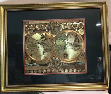
Sold2021Decorative Framed Double Hemisphere MapDESCRIPTION: A decorative framed double hemisphere map with figural and gilt details throughout. Mounted in a gilt accented wood frame. Marked: "The Bombay Company" at reverse. CIRCA: 20th Cent. ORIGISee Sold Price
Sold2023Vintage GOLD FOIL WORLD MAP DOUBLE HEMISPHERE 25x31 FRAMED Wall HangingVintage Huge GOLD FOIL WORLD MAP DOUBLE HEMISPHERE 25x31 FRAMED Wall Hanging in a Gorgeous Gold Leaf Frame in VG Condition. Local Pickup Only in Berlin NJ 08009 or UPS Store Shipping Paid for by the WSee Sold Price
Sold2020Framed 1822 World Map, FrenchDated 1822 world map in frame. This map is hand colored and tilted Mappemomde (French for a map showing two hemispheres). This map is double matted in contemporary frame.Condition: very good conditionSee Sold Price
Sold2022MAP OF WESTERN HEMISPHERE (AMERICAS)Bowen, Emanuel. A NEW AND ACCURATE MAP OF AMERICA (London, ca. 1745). Double page engraving. Hand colored. Framed and mounted. Highly detailed map of Western Hemisphere showing the Americas, Pacific iSee Sold Price
Sold2022Adam Friedrich (1679-1742) Double Hemisphere MapProperty of a Private Collector, Hilton Head Island, SC Description: Adam Friedrich (1679-1742), Planisphaerium Terrestre Cum Utraque Coelesti Hemisphario, Amsterdam: Nicolaum Vissche, c. 1700 orSee Sold Price
Sold20191628 Vaughan double Hemisphere Map of the World -- AReserve Reduced! Title/Content of Map: 1628 Vaughan double Hemisphere Map of the World -- A New and accurate Mappe of the World, drawne according to the best and latest discoveries that have beene madSee Sold Price
Sold2024Ptolemy & Magini, pub. 1620 - Double Hemisphere Map of the WorldThis early map engraving is from Claudius Ptolemaeus (Ptolemy) and Giovanni Antonio Magini's Geografia cio? Descrittione Universale della Terra Partita in due volumni, Nel Primo de' quali si contengonSee Sold Price
Sold2024[WORLD]. ROBISON, Edward C. Manuscript double-hemisphere map of the world. 1831.[WORLD]. ROBISON, Edward C. Manuscript double-hemisphere map of the world. 1831. 1830 Manuscript double-hemisphere map of the world, in ink and colors, hand-colored in outline, within pink and green bSee Sold Price
Sold2020Latin Double Hemisphere Map in Bronze FrameDouble hemisphere map of the world by Henricus Hondius II (Dutch, 1597-1651), offset print, in a bronze frame. [Sight: 20 1/2 x 29 1/2 inches; Frame: 22 x 31 inches]. In good condition.See Sold Price
Sold20191784 Two Double Hemisphere Maps ProjectionsTwo double hemisphere projections, one being a Stereographic map and the other with an Orthographic Projection, both published by Harrison and Co, London, 1784. Each Fine, measures 10 x 8”. Reserve:See Sold Price
Sold2021Pair Decorative Framed MapsPair of decorative framed maps. Sights 12" x 15 1/2", overall 24" x 28 1/4".See Sold Price
Sold2022Marvelous pictorial map of the WorldHeading: (Maps) Author: Ensign & Thayer Title: World at One View Place Published: New York Publisher: Date Published: 1847 Description: Lithographed double-hemisphere map of theSee Sold Price
Sold2023[MAP]. HOMANN, Johann Baptist (1663-1724). Planiglobii Terrestris cum utroq Hemisphaerio[MAP]. HOMANN, Johann Baptist (1663-1724). Planiglobii Terrestris cum utroq Hemisphaerio Caelesti… Nuremberg, [ca 1720]. Engraved double-hemisphere map of the world with hand-coloring in wash anSee Sold Price
Sold20244 Antique Maps of Various LocationsFrench Map of Canada By Guillaume Del'Isle, Map Of Asia By Guiljelmo Blaeuw, Double Hemisphere map By Nicolao Visscher, Map Of The Holy Land Jerusalem, all maps are roughly 18" x 14"See Sold Price
Sold2017Launay World Map - Typus Orbis Terrarum, 1720Map: Launay World Map - Typus Orbis Terrarum Cartographer: C. Launay Date: ca. 1720 Size: 5 x 8 inches A quite rare, unique and charming double hemisphere map showing very rough approximations for theSee Sold Price
Sold2023Planiglobii Terrestris Mappa Universalis Utrumqs Hemisphaerium Orient et OccidentaleNeuremberg: Homann Heirs, 1746. Double hemisphere map of the world, with four globes tangential to the hemispheres, showing earth from various angles in addition to the expected polar views. Two diagrSee Sold Price
Sold2021De L'Isle Philippe Buache engraved map of Antique ItalyDe L'Isle Philippe Buache Double hemisphere map of Antique Italy 1800 Important map of Guillaume de L'Isle corrected by Philippe Buache and edited by Dezauche in 1800 ,This one is not revised by DezauSee Sold Price
Sold2021After Henricus Hondius II (Dutch, 1597-1651)After Henricus Hondius II (Dutch, 1597-1651) , "Nova Totius Terrarum Orbis Geographica AC Hydrographica Tabula", later printing, hand-colored double-hemisphere map, exuberantly decorated with represenSee Sold Price
Sold20181782 A New Map of the World1782 "A New Map of the World", double hemisphere map published by Harrison and Co., London, 1782. Folding map, measures 17 x 10". Fine, mild discoloration. Reserve: $80.00 Shipping: Domestic: Flat-ratSee Sold Price
Sold20191782 A New Map of the World1782 “A New Map of the World”, double hemisphere map published by Harrison and Co., London, 1782. Folding map, measures 17 x 10”. Fine, mild discoloration. Reserve: $80.00 Shipping: Domestic: FlSee Sold Price
2022Blaeu, Johannes (Netherlands, 1596-1673) "The New World Map" Double Hemisphere World Map C. 1664Nova et Accuratissima Totius Terrarum Orbis Tabula Translated "The New World Map", Hand Colored w/ Elaborately Decorated Spandrels.   Sight View 16" x 21-1/2", Overall View 21" x 25-1/2"See Sold Price
Sold20201746 Homann Double Hemisphere World Map -- PlaniglobiiTitle/Content of Map: 1746 Homann Double Hemisphere World Map -- Planiglobii Terrestris Mappa Universalis utrumque Hemisphaerium Orient et Occidentale Repraesentans ex IV. Mappis Generalibus ... / MapSee Sold Price
Sold2021Double hemisphere world map with additionalTitle: Double hemisphere world map with additional projections. 1752 by Homann Heirs Date/Period: 1762 Materials: Copperplate engraved Size: 24 x 20 1/2 1762, by J. B. Homann & Homann Heirs, from "AtlSee Sold Price
2022Seutter, Matthaus (Germany, 1678-1757) Double Hemisphere World Map C. 1730Sight View  19-1/2" x 23", Overall View 22" x 25", Hand Colored "Quibus Addita, Pro Mutatione Horizontis Differentes Sphara Po Sitiones Earumque Convenientia Et RelaSee Sold Price
3 days LeftFreeman's | Hindman[MAP]. ORTELIUS, Abraham. Americae Sive Novi Orbis, Nova Descriptio. 1573.$1,000(1 bid)
3 days LeftFreeman's | Hindman[MAP]. ORTELIUS, Abraham. Presbiteri Iohannis, sive, Abissinorum Imperii Descriptio. 1592.$200
Jun 13Swann Auction Galleries(AMERICAS.) Nicolas Visscher. Novissima et Accuratissima Totius Americae Descriptio.$500
5 days LeftWorthington GalleriesAntique Hand-colored Hemisphere Map Mappemonde Revue par E. Cortambert 1864$25
4 days LeftLeon GalleryVincenzo Maria Coronelli (1650-1718) - Asia Divisa Nelle sue Parti Secondo lo Stato Presente₱220,000
5 days LeftWorthington Galleries19th c. Hemisphere World Map, Hohen und Tiefen der Erde in Lambert’s Zenithal-Projection von$10
BonhamsETHIOPIA, SOUTH AFRICA AND MADAGASCAR BLAEU (WILLEM) Aethiopia Superior vel Interior, [Amsterdam...£300
BonhamsAFRICA DE WIT (FREDERICK) Totius Africae Accuratissima Tabula,Amsterdam, Frederick de Wit, [c.16...£60(4 bids)
Jun 13Swann Auction Galleries(RUSSIA.) Abraham Ortelius. Russiae, Moscoviae et Tartariae Descriptio.$500
Jun 13Swann Auction Galleries(ITALY.) Henricus Hondius. Italia Nuovamente Piu Perfetta Che Mai Per Inanzi Posta in Luce.$450
3 days LeftFreeman's | Hindman[MAP]. ORTELIUS, Abraham. Peregrinationis Divi Pauli Typus Corographicus. 1592.$150(1 bid)
4 days LeftEarly American History Auctions1776 Map, PARTIE ORIENTALE DU CANADA, AVEC LA NOUVELLE ANGLETERRE, L'ACADIE... by P. Santini, Framed$950
5 days LeftWorthington GalleriesFirst Edition Hand-colored Map THE NORTH RIDING OF YORKSHIRE by Robert Morden$50


![[WORLD]. ROBISON, Edward C. Manuscript double-hemisphere map of the world. 1831.: [WORLD]. ROBISON, Edward C. Manuscript double-hemisphere map of the world. 1831. 1830 Manuscript double-hemisphere map of the world, in ink and colors, hand-colored in outline, within pink and green b](https://p1.liveauctioneers.com/197/321050/172516760_1_x.jpg?height=310&quality=70&version=1709074257)
![Latin Double Hemisphere Map in Bronze Frame: Double hemisphere map of the world by Henricus Hondius II (Dutch, 1597-1651), offset print, in a bronze frame. [Sight: 20 1/2 x 29 1/2 inches; Frame: 22 x 31 inches]. In good condition.](https://p1.liveauctioneers.com/1221/177486/89638020_1_x.jpg?height=310&quality=70&version=1599275200)


![[MAP]. HOMANN, Johann Baptist (1663-1724). Planiglobii Terrestris cum utroq Hemisphaerio: [MAP]. HOMANN, Johann Baptist (1663-1724). Planiglobii Terrestris cum utroq Hemisphaerio Caelesti… Nuremberg, [ca 1720]. Engraved double-hemisphere map of the world with hand-coloring in wash an](https://p1.liveauctioneers.com/197/284572/150193667_1_x.jpg?height=310&quality=70&version=1680880467)


![[MAP]. ORTELIUS, Abraham. Americae Sive Novi Orbis, Nova Descriptio. 1573. (1 of 2)](https://p1.liveauctioneers.com/197/329395/177650534_1_x.jpg?height=282&quality=70&version=1715364962)
![[MAP]. ORTELIUS, Abraham. Turcici Imperii Descriptio.1592. (1 of 2)](https://p1.liveauctioneers.com/197/329395/177650538_1_x.jpg?height=282&quality=70&version=1715364962)
![[MAP]. ORTELIUS, Abraham. Romani Imperii Imago. 1592. (1 of 2)](https://p1.liveauctioneers.com/197/329395/177650537_1_x.jpg?height=282&quality=70&version=1715364962)
![[MAP]. SPEED, John. A New Mappe of the Romane Empire. 1676. (1 of 2)](https://p1.liveauctioneers.com/197/329395/177650541_1_x.jpg?height=282&quality=70&version=1715364962)
![[MAP]. ORTELIUS, Abraham. Aevi Veteris, Typus Geographicus. 1601. (1 of 3)](https://p1.liveauctioneers.com/197/329395/177650532_1_x.jpg?height=282&quality=70&version=1715364962)
![[MAP]. ORTELIUS, Abraham. Presbiteri Iohannis, sive, Abissinorum Imperii Descriptio. 1592. (1 of 2)](https://p1.liveauctioneers.com/197/329395/177650536_1_x.jpg?height=282&quality=70&version=1715364962)


![[MAP]. ORTELIUS, Abraham. Peregrinationis Divi Pauli Typus Corographicus. 1592. (1 of 2)](https://p1.liveauctioneers.com/197/329395/177650535_1_x.jpg?height=282&quality=70&version=1715364962)
![[MAP]. ORTELIUS, Abraham. Africae Tabula Nova. 1592. (1 of 2)](https://p1.liveauctioneers.com/197/329395/177650533_1_x.jpg?height=282&quality=70&version=1715364962)


