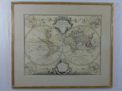
Sold2020Framed 1822 World Map, FrenchDated 1822 world map in frame. This map is hand colored and tilted Mappemomde (French for a map showing two hemispheres). This map is double matted in contemporary frame.Condition: very good conditionSee Sold Price
Sold2021Framed 1822 French map of IndianaFramed 1822 French map of Indiana, shows Indian territories and 35 of the 92 counties, but it's in French! 25.5"H x 32"W overall in contemporary frameSee Sold Price
Sold2023Antique Carte Pour L' Intelligence Du Livre Institute L' Esprit De S Loix Old World Framed MapAntique French framed old world map with gold tone frame. Professionally framed. Measures 15 1/2" x 24" total with 9" x 18" matte.See Sold Price
Sold2022Vintage Air France Airline Travel Routes World MapVintage Air France Airline Travel Routes World Map, by Lucien Boucher (French, 1889-1971) color offset, C.1948. Framed. Size: 19.5'' x 33.75'', 50 x 86 cm (sight); 24.5'' x 39'', 62 x 99 cm (frame).See Sold Price
Sold2015Lg Framed early 19th c. Map of the WorldLg Framed early 19th c. Map of the World, "Mappe Monde", Indication des trois voyages du Capitaine Cook, French 1816 in floral gilt 32" x 46" frame Condition; was folded, some wear along fold lines frSee Sold Price
Sold2017FRAMED WORLD MAP BY HERMAN MOLL, 1719'A New & Correct Map of the Whole World, by Herman Moll, Geographer, 1719.' Hand tinted and framed. Frame size: 73 x 124 cm (28 3/4 x 48 3/4 in.)See Sold Price
Sold20223 PC. FRAMED WORLD MAPS3 PC. FRAMED WORLD MAPS: Comprising; 1- A reduced scale world map based on Mercator's map of 1569. 1- 18th-century hand-colored, A New Map of the Whole World with the Tradewinds According To The LatesSee Sold Price
Sold2016Large Framed World Map w/ Latin InscriptionsLarge Framed World Map w/ Latin Inscriptions. Hand colored. Professionally framed and matted. Titled Mappe Monde. Measures 28 by 33 inches.See Sold Price
Sold2023Handcrafted Gemstones Framed World MapHandcrafted Gemstones Framed World Map. 23 1/2 x 31 3/8 in.Local Pick up call one day before to make an appointment. TO SHIP THIS ITEM IN USA OR INTERNATIONAL, PLEASE CONTACT THE SHIPPERS : 1) UPS stoSee Sold Price
Sold2020FRAMED WORLD MAPCondition: with crease mark from book, spotting, and foxing throughout 11 x 16 1/2 inches sightSee Sold Price
Sold2022C. S. Hammond & Co. NY Framed World MapC. S. Hammond & Co. NY Framed World Map. 24 1/2" X 20 1/2"See Sold Price
Sold2021Framed World Map PrintA framed print of a world map as the world was thought to look like in 1632. Map shows both hemispheres laid flat side by side with text and labels in foreign language. Very good condition. Measures 3See Sold Price
Sold2021Framed World MapFramed World map, Blaeu wall map, color print with areas of silvered paper, double matted in mahogany finish 25" x 29" frame. Condition; very goodSee Sold Price
Sold20172 Framed World Maps including Blaeu Wall Map2 Framed World Maps including Blaeu Wall Map. Largest measures 22 x 26 inches.See Sold Price
SoldVintage 1960s Old World Style Metalic Framed World Map ArtworkVery unique styling. See photos for details.29.25" wide25.25" tall1.5" deepSee Sold Price
Sold2017A Group of Three Framed World Maps, 20th CenturyA Group of Three Framed World Maps, 20th Century20 x 28 inches (50.8 x 71.1 cm) (image, laSee Sold Price
Sold2018Kilburg Geochron Wall Mounted World ClockKilburg Geochron Wall Mounted World Clock. The Geochron allows any observer to determine what time it is anywhere in the world. Physically the Geochron looks like a framed world map, about 2×3 ft.See Sold Price
Sold2023Illuminated World MapIlluminated Walnut Framed World Map. Dimensions 19x25.5x4.5See Sold Price
Sold2019Early 1900s World Map of French Colonies -- LigueTitle: Early 1900s World Map of French Colonies -- Ligue Maritime et Coloniale Francaise Date: early 1900s Cartographer: Reconnue d'Utilite Publique Size: 29.5 X 44.5 in. Additional Information: ThisSee Sold Price
Sold2023FRAMED ANTIQUE WORLD MAP BY PETER APIAN - 1520Description: FRAMED ANTIQUE WORLD MAP BY PETER APIAN - 1520Measurement approximate:Material: PaperSee Sold Price
Sold20241822 Woodbridge World Map -- The WorldTitle: 1822 Woodbridge World Map -- The World Cartographer: W. Woodbridge Year / Place: 1822, Hartford Map Dimension (in.): 9.4 X 12.3 in. page This is a very nice double hemisphere world map. It alsoSee Sold Price
17 hrs LeftJasper521817 3 VOYAGES of CAPTAIN COOK 6 vols ILLUSTRATED w/ WORLD MAP antique in FRENCH$1,000
2 days LeftOriental Art AuctionsA RARE NON COLORED PRINTED FRENCH MAP OF THE ARABIC WORLD DURING THE OTTOMAN EMPIRE (ARABIA€1,000
2 days LeftPotter & Potter AuctionsAir France / Reseau Aerien Postal. 1948. Paris: Perceval. L...$150
May 22Thomaston Place Auction GalleriesHAND COLORED MAP OF PERU & COUNTRY OF THE AMAZONS, 1747, BY EMANUEL BOWEN, FRAMED$250
6 days LeftKCM GalleriesGUSTAVE DORE 1800s Wood Engraving "The Punishment Of Flatterers" FRAMED Signed$425
6 days LeftKCM Galleries1800s Gustave DORE Biblical Wood Engraving Peter Denies Jesus Again FRAMED SIGNED$400
6 days LeftKCM GalleriesSIGNED 1800s GUSTAVE DORE Biblical Woodcut Jehu's Companions Find Jezebel FRAMED$410
6 days LeftKCM GalleriesGustave DORE SIGNED 1800s Religious Wood Engraving THE KING ON THE CROSS Framed$1,300
7 days LeftKensington Estate AuctionTheodore Rousseau (French, 1812-1867) Chenes de Roche (Rock Oaks), 1861$100
2 days LeftJasper52WORLD WAR 2. Siegfried & Maginot line defences. Pre-invasion of France 1940 map$30
2 days LeftJasper52WORLD WAR 2. Maginot & Siegfried line defences. Pre-invasion of France 1940 map$25
6 days LeftKCM Galleries1800s Gustave Dore Biblical Woodcut Mattathias & the Apostate Framed Signed$380
6 days LeftKCM Galleries1800s Gustave Dore Wood Engraving The Ninth Plague: Darkness Framed Signed$510
6 days LeftKCM GalleriesGustave DORE'S BIBLE 1800s Wood Engraving Jesus Beneath The Cross Framed SIGNED$1,200