Sold2021Boating maps, Nassau Harbour, New Providence Island,Maps from 1981 tropic Isle publishers, Inc By Harry Kline, Nassau Harbour, new Providence Island, Little Harbor and alder cay anchorages. Size 11“ x 17“See Sold Price
Sold2021Boating maps, western New Providence, rose island,Maps from 1981 tropic Isle publishers, Inc By Harry Kline, Western New Providence, rose Island, eastern approaches to Nassau harbour. Size 11“ x 17“See Sold Price
Sold2021Boating maps, the Jumentos Cays end drag at IslandMaps from 1981 tropic Isle publishers, Inc By Harry Kline, The Jumentos Cays in Ragan Island harbour, French wells and turtle sound, crooked Acklins islands. Size 11“ x 17“See Sold Price
Sold2018West Indies the Bahama Islands Exuma to New ProvidenceTitle/Content of Map: West Indies the Bahama Islands Exuma to New Providence Date Printed: 01/07/1975 Cartographer: HYDROGRAPHIC OFFICE. ROYAL NAVY Size (inches): 38X25 Detailed nautical chart. CopiouSee Sold Price
Sold2023POLYNESIA/PACIFIC ISLANDS. inc Sandwich/Hawaiian islands. RAPKIN/TALLIS 1851 mapCAPTION PRINTED BELOW PICTURE: 'Polynesia or Islands in the Pacific Ocean' Vignettes: Resolution Bay, Marquesas; Harbour of Dory, New Guinea; Otaheite [Tahiti]; Kalakakooa, Sandwich Islands [HawaiianSee Sold Price
Sold2018POLYNESIA/PACIFIC ISLANDS. inc Sandwich/HawaiianTITLE/CONTENT OF MAP: 'Polynesia or Islands in the Pacific Ocean' Vignettes: Resolution Bay, Marquesas; Harbour of Dory, New Guinea; Otaheite [Tahiti]; Kalakakooa, Sandwich Islands [Hawaiian islands].See Sold Price
2018POLYNESIA/PACIFIC ISLANDS. inc Sandwich/HawaiianReserve Reduced! TITLE/CONTENT OF MAP: 'Polynesia or Islands in the Pacific Ocean' Vignettes: Resolution Bay, Marquesas; Harbour of Dory, New Guinea; Otaheite [Tahiti]; Kalakakooa, Sandwich Islands [HSee Sold Price
Sold20231852 Map of New York City1852 map "Plan of the City of NY," copy of D. Longwerth's Map of 1808 for D.T. Valentine's Manuel for 1852. Includes North or Hudson River, Port of Nassau of Long Island. Encompasses 1-10 wards. LithoSee Sold Price
Sold2021Boating Maps, Long Island, Long Island north end, eastMaps from 1981 tropic Isle publishers, Inc. by Harry Klein, Long Island, Long Island Northwynn, East Coast harbors. Size, 11” x17”See Sold Price
Sold2021Boating maps, crooked island district, little SanMaps from 1981 tropic Isle publishers, Inc By Harry Kline, Crooked island district, little San Salvador little island or little cat island, cat island and little San Salvador. Size 11“ x 17̶See Sold Price
Sold2021Boating maps, royal island harbor, egg islands, currentMaps from 1981 tropic Isle publishers, Inc By Harry Kline, Royal island harbor, egg Islands, current island Anchorage. Size 11“ x 17“See Sold Price
Sold2019Bahamian Governor William Shirley Writes of EspionageShirley William Manuscript Document Signed "W Shirley" as Governor of the Bahamas, 2 pages, 9" x 14.25", front and verso. New Providence, Bahama Islands, August 27, 1762. Also signed by the author ofSee Sold Price
Sold2021Boating maps, Southern Berry islands, Central BerryMaps from 1981 tropic Isle publishers, Inc By Harry Kline, Southern Berry Islands, Central Berry islands, Northern Berry islands. Size 11“ x 17“See Sold Price
Sold2017Bellin: Antique Map of New Zembla Island, 1750Title/Content of Map: Island of New Zembla Northern Russia Arctic Ocean Date Printed: 1750's -60's Cartographer: Jacques Nicolas Bellin Material/Medium: Paper Size: 9 1/2" x 7" Copperplate engraving.See Sold Price
Sold2022William B. Durgin Co. Bug cold meat forkWilliam B. Durgin Co. Bug cold meat fork with insect and snake motif Concord, New Hampshire & Providence, Rhode Island, circa 1885 sterling silver stamped marks engraved M monogram 1 5/16"w x 8 5/8"lSee Sold Price
Sold2022William B. Durgin Co. Bug sauce or gravy ladleWilliam B. Durgin Co., retailed by Hugo Beil of Boston Bug sauce or gravy ladle insect and snake motif Concord, New Hampshire & Providence, Rhode Island, circa 1885 sterling silver parcel-gilt stampedSee Sold Price
Sold2018A Pair of Wm. B. Durgin Co. Silver Candlesticks,A Pair of Wm. B. Durgin Co. Silver Candlesticks, Concord, New Hampshire & Providence, RhodSee Sold Price
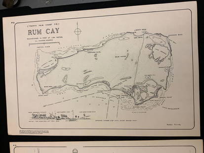
Sold2021Boating maps, rum cay, conception island, San Salvador.Maps from 1981 tropic Isle publishers, Inc By Harry Kline, Rum Cay, Conception island, San Salvador. Size 11“ x 17“See Sold Price
Sold2021Boating maps, harbors creeks cat Island, Turks andMaps from 1981 tropic Isle publishers, Inc By Harry Kline, Harbors creeks cat Island, Turks end Caicos Islands. 11“ x 17“See Sold Price
Sold2019Bryce, James 1881 Map of New Zealand South IslandLithograph Map Published 1881, London for ""The International Atlas and Geography..." by James Bryce. Maps by Edward Weller & John Bartholomew. Uncommon. Paper Size: 18 x 13 inch (46 x 33cm) Good CondSee Sold Price
Sold2019Bryce, James 1881 Map of New Zealand North IslandLithograph Map Published 1881, London for ""The International Atlas and Geography..." by James Bryce. Maps by Edward Weller & John Bartholomew. Uncommon. Paper Size: 18 x 13 inch (46 x 33cm) Good CondSee Sold Price
Sold2017Buache: Antique Map of New York, Long Island, 1807Map: Ile de New-York Partie de Long-Island ou de l'Ile Longue et positions des armées Américaine et Britannique après le combat livré sur les hauteurs, le 27 Août, 1776. Maker: Buache, Jean NicolSee Sold Price
Sold2021Boating Maps, Bahamas for out islands, The BahamaMaps from 1981 tropic Isle publishers, Inc By Harry Klein, Bahamas far out islands, The Bahama Islands, airstrip locations.See Sold Price
Sold2016Map of New Zealand, North Island, 1902Title: Map of New Zealand, North Island Original engraving by George Cram Date: 1902 Dimensions: 11 x 14 inches No Reserve: This lot starts at $1 and has no reserve as a courtesy so that collectors caSee Sold Price
Featured5 days LeftJasper521867 Beers Map of New York City Area -- Map of New York and Vicinity Accompanying "Atlas of New York$200
Featured5 days LeftJasper521750 Bowen Map of Bermuda and St. Kitts -- A New & Accurate Map of Bermudas or Sommer's Islands...$600
6 days LeftForum AuctionsExecution broadside.- Australia.- More of the Horrors of Transportation: Giving the full Particulars£600
5 hrs LeftRapid Estate Liquidators and Auction GalleryThe Newsday Magazine 1982 Marilyn Monroe Anniversary$35
Featured5 days LeftJasper52c1720 World showing Dutch East India Co possessions. CA as a island. By J.Malherbe$600
5 days LeftJasper521723 Dampier Map of Voyages to Brazil, Australia and Eat Indies -- Voyage du Cap. Dampier a la N.$280
1 day LeftTrillium Antique Prints & Rare BooksPrevost - Chart of the Gulf of Mexico (with Florida & Lousiana)$50(1 bid)
Jun 06Freeman's | HindmanSTEVENSON, Robert Louis (1850-1894). Treasure Island. London, Paris & New York: Cassell & Company,$1,500
1 day LeftTrillium Antique Prints & Rare BooksWilkes - 4 Engravings of Trees & Mountains in Nu?uanu Pali, Hawaii / Upolu, Samoa / New South Wales,$100


![POLYNESIA/PACIFIC ISLANDS. inc Sandwich/Hawaiian islands. RAPKIN/TALLIS 1851 map: CAPTION PRINTED BELOW PICTURE: 'Polynesia or Islands in the Pacific Ocean' Vignettes: Resolution Bay, Marquesas; Harbour of Dory, New Guinea; Otaheite [Tahiti]; Kalakakooa, Sandwich Islands [Hawaiian](https://p1.liveauctioneers.com/5584/298779/159029476_1_x.jpg?height=310&quality=70&version=1692132475)
![POLYNESIA/PACIFIC ISLANDS. inc Sandwich/Hawaiian: TITLE/CONTENT OF MAP: 'Polynesia or Islands in the Pacific Ocean' Vignettes: Resolution Bay, Marquesas; Harbour of Dory, New Guinea; Otaheite [Tahiti]; Kalakakooa, Sandwich Islands [Hawaiian islands].](https://p1.liveauctioneers.com/5584/128489/65352606_1_x.jpg?height=310&quality=70&version=1538523113)
![POLYNESIA/PACIFIC ISLANDS. inc Sandwich/Hawaiian: Reserve Reduced! TITLE/CONTENT OF MAP: 'Polynesia or Islands in the Pacific Ocean' Vignettes: Resolution Bay, Marquesas; Harbour of Dory, New Guinea; Otaheite [Tahiti]; Kalakakooa, Sandwich Islands [H](https://p1.liveauctioneers.com/5584/129679/65959649_1_x.jpg?height=310&quality=70&version=1540338370)