Sold2021Boating maps, harbors creeks cat Island, Turks andMaps from 1981 tropic Isle publishers, Inc By Harry Kline, Harbors creeks cat Island, Turks end Caicos Islands. 11“ x 17“See Sold Price
Sold2021Boating Maps, Elizabeth Harbor, Pike Creek, ElizabethMaps from 1981 tropic Isle publishers inc, by Harry Klein, Elizabeth Harbor, pipe Creek, Elizabeth Harbor to hog Cay, size 11“ x 17“See Sold Price
Sold2021Boating maps, Spanish wells to Harbor Island, cays toMaps from 1981 tropic Isle publishers, Inc By Harry Kline, Spanish wells to Harbor Island, cays to Eleuthera, current cut and current settlement. Size 11“ x 17“See Sold Price
Sold2021Boating maps, royal island harbor, egg islands, currentMaps from 1981 tropic Isle publishers, Inc By Harry Kline, Royal island harbor, egg Islands, current island Anchorage. Size 11“ x 17“See Sold Price
Sold2021Boating maps, crooked island district, little SanMaps from 1981 tropic Isle publishers, Inc By Harry Kline, Crooked island district, little San Salvador little island or little cat island, cat island and little San Salvador. Size 11“ x 17̶See Sold Price
Sold2021Boating maps, Nassau Harbour, New Providence Island,Maps from 1981 tropic Isle publishers, Inc By Harry Kline, Nassau Harbour, new Providence Island, Little Harbor and alder cay anchorages. Size 11“ x 17“See Sold Price
Sold2021Boating Maps, Long Island, Long Island north end, eastMaps from 1981 tropic Isle publishers, Inc. by Harry Klein, Long Island, Long Island Northwynn, East Coast harbors. Size, 11” x17”See Sold Price
Sold2021Boating maps, Southern Berry islands, Central BerryMaps from 1981 tropic Isle publishers, Inc By Harry Kline, Southern Berry Islands, Central Berry islands, Northern Berry islands. Size 11“ x 17“See Sold Price
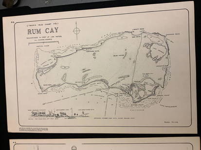
Sold2021Boating maps, rum cay, conception island, San Salvador.Maps from 1981 tropic Isle publishers, Inc By Harry Kline, Rum Cay, Conception island, San Salvador. Size 11“ x 17“See Sold Price
Sold2021Boating Maps, Bahamas for out islands, The BahamaMaps from 1981 tropic Isle publishers, Inc By Harry Klein, Bahamas far out islands, The Bahama Islands, airstrip locations.See Sold Price
Sold2021Boating maps, western New Providence, rose island,Maps from 1981 tropic Isle publishers, Inc By Harry Kline, Western New Providence, rose Island, eastern approaches to Nassau harbour. Size 11“ x 17“See Sold Price
Sold2021Boating maps, The brights of intros, Stafford Creek toMaps from 1981 tropic Isle publishers, Inc By Harry Kline, The brights of andros, Stafford Creek to North bright, jousters cays to Stanford creek. Size 11“ x 17“See Sold Price
Sold2017Mitchell: Antique Map of Palestine, 18481861 Johnson’s China. Lovely map of China with original hand coloring. Features two insets: Harbor & Island of Amoy, and Map of Canton and Adjacent Islands. Very clean with good impression. From theSee Sold Price
Sold2020Harbor Chart of Thimble Islands and Stony CreekHarbor Chart of Thimble Islands and Stony Creek. . Title: Harbor Chart of Thimble Islands & Stony,. Medium: Print. Size: 15 X 20 in. Signature: Unsigned. Artist: Geo. W. Eldridge. Framed.See Sold Price
Sold2021Boating maps, the Jumentos Cays end drag at IslandMaps from 1981 tropic Isle publishers, Inc By Harry Kline, The Jumentos Cays in Ragan Island harbour, French wells and turtle sound, crooked Acklins islands. Size 11“ x 17“See Sold Price
Sold2021Boating maps, Powell Point to rock sound, EleutheraMaps from 1981 tropic Isle publishers, Inc By Harry Kline, Powell point to rock sound, Eleuthera island, Spanish wells and ridley head channel. Size 11“ x 17“See Sold Price
Sold2021Boating Maps, Brock cay to channel cay, bitter guanaMaps from 1981 tropic Isle publishers, Inc, by Harry Kline, Brock Cay to Channel Cay, Bitter Guana Cay to Brock Cay, Bimini Cat Cay. size, 11“ x 17“See Sold Price
Sold2021Boating maps, Allen’s Highborne, The Bahamas,Maps from 1981 tropic Isle publishers, Inc By Harry Kline, Allen’s highborn, The Bahamas, South Bright to hawksbill Creek, size 11“ x 17“See Sold Price
Sold2022Topographical Maps of Vineyard Nantucket Sound, StTopographical Maps of Vineyard Nantucket Sound, St Joseph Sound, Cape Cod Bay, Medield, and Massachusetts Harbor Islands. Group of 6 Mid Century Geological Survey maps. Largest 23 x 27 inches. Small eSee Sold Price
Sold2019Cohasset harbor map and chartWAR DEPARTMENT MAP AND CHART OF COHASSET HARBOR. Detailed map of the South Shore from Boston to Cohasset showing harbors and coves including Whitehead, Bailey Creek, Bassing Beach etc.. Framed . DimenSee Sold Price
Sold2023MAP: United States - East Coast. Thames River New York London Harbor Long Island to NorwichDescription: United States - East Coast Connecticut - New York. Thames River/ New York London Harbor Long Island to Norwich. Published at Washington D.C. US Department of Commerce, Environmental ScienSee Sold Price
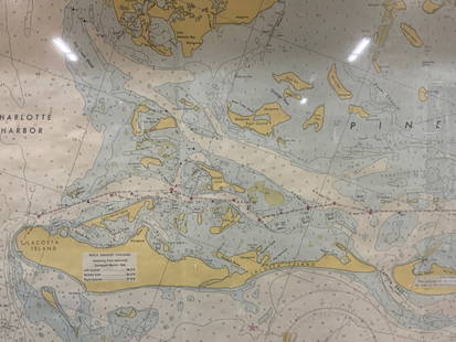
Sold2024Vintage Framed Pine Island & Lacoste Island MapVintage full color paper map, marked on top Pine island, Charlotte harbor and Lacosta island. Showing waterways and directions. Framed in a wooden frame. Approx 14 x 18 inches window measures 11.5 x 1See Sold Price
Sold2023E. Belcher Hyde Map Co. - Maps of Sag Harbor, Group of 2Lot 48 E. Belcher Hyde Map Co. American Manufacturer (fl. c. 1880 - 1920) Maps of Sag Harbor, Group of 2 (1916) lithograph with hand coloring from Suffolk County 1916 Vol 2 Long Island, New York 17 xSee Sold Price
Sold2019Three Maps from the Hydrographic Office U. S. Navy, theThree Maps from the Hydrographic Office U. S. Navy, the first "North Pacific Ocean, Caroline Islands, North Coast of Ponape Island, Ponape Harbor to Talak Passage," 1944, H. -30 in., W. -42 in.; withSee Sold Price
1 day LeftRapid Estate Liquidators and Auction GalleryVintage Framed Cat Island Nautical Map Print$55
Crawford Family Auctions LLC6 pcs Vintage Paper Maps. Vancouver Island, British Columbia. Upper Elk Creek Sheet. See pics.$20
Jun 08Early American History Auctionsc 1730 Hand-Colored Colonial Era Map of the Americas, California shown as an Island, Matted + Framed$500(1 bid)
6 days LeftJasper52Title/Content of Map: Puerto Rico: Port of Guánica by Ferrer Date Printed: 1818$55
6 days LeftJasper52Title/Content of Map: Plano de Puerto de Delfin (Baie de Fort Liberte, Haiti) Date Printed: 1818$55
6 days LeftJasper52Title/Content of Map: Haiti: Fondeadero de Chouchou (N. coast of Haiti) and Bahia de la Granja by$55
2 hrs LeftJasper52After Charles Antoine Coypel, Sancho Panza arriving on Barataria Island (Don Quijote), 1723-1724$140
Jun 05Jasper52Le Canal de Mosambique, l'Isle de Madagascar… Mozambique. Africa. BONNE 1790 map$20
Jun 07Freeman's | HindmanKEOUGH, Pat and Rosemarie. Labyrinth Sublime: The Inside Passage. 2011. LIMITED EDITION, SIGNED.$250