Sold2016Blaeu, W.: Walachia, Servia, Bulgaria, Romania Map 1635Map: Walachia, Servia, Bulgaria, Romania Publishing: Blaeu, W.: Amsterdam Date: 1635 Size: 15 x 20 inches Early edition of a very attractive map of the Balkans, shown during the occupation by the OttoSee Sold Price
Sold20181644 Blaeu Map of Eastern Balkans -- Walachia, Servia,Title/Content of Map: 1644 Blaeu Map of Eastern Balkans -- Walachia, Servia, Bulgaria, Romania Date Printed: 1644, Amsterdam Cartographer: W Blaeu Size: 15.2 x 20.1 in. This is a very nice map of theSee Sold Price
Sold2020Early 19th Century Hand Colored Transylvania MapMercator (Gerard) Transylvania, Sibenburgen; Walachia Servia, Bulgaria, Romania,northern Romania, and eastern Europe. Nicely hand colored and in good overall well kept condition. Not having been laidSee Sold Price
Sold20221602 Ortelius Map of the Balkans -- Romania, Bulgaria, Walachia et SyrfiaTitle: 1602 Ortelius Map of the Balkans -- Romania, Bulgaria, Walachia et Syrfia Cartographer: A Ortelius Year / Place: 1602, Antwerp Map Dimension (in.): 3 X 4 in. This is a very nice smaller map ofSee Sold Price
Sold2024Blaeu, pub. 1635 - Map of Romania: TransylvaniaThis remarkable, map with original hand-coloring is is Jan Blaeu's Le Theatre du Monde ou Nouvel Atlas Contenant, Les Chartes et Descriptions de tous les Pais de la Terre Mis en lumiere. This is fromSee Sold Price
Sold2018Blaeu Map of Europe -- Europa Recens DescriptaTitle/Content of Map: Blaeu Map of Europe -- Europa Recens Descripta Date: 1635, Amsterdam Cartographer: W Blaeau Size: 16.1 X 21.9 in. This is a grand, large, classic map of Europe, produced at the gSee Sold Price
Sold2018(1635) Blaeu Map: Mappa Aestivarvm Insularum,...Historic Maps Hand-Colored "Mappa Aestivarvm Insularum, alias Barmvdas dictarum..." by Willem J. Blaeu, Amsterdam (1635) Hand-Colored Historic Dutch Map titled: "Mappa Aestivarvm Insularum, alias BarmSee Sold Price
Sold2021Blaeu 1635 Map of Tartaria (Northern Asia)Finely engraved map by cartographer Blaeu depicting Tartaria, a term used for Central and Northern Asia. This map includes knowledge of English and Dutch explorers through Greek classics, such as mythSee Sold Price
Sold2021Blaeu 1635 Map of Tartaria (Northern Asia)Finely engraved map by cartographer Blaeu depicting Tartaria, a term used for Central and Northern Asia. This map includes knowledge of English and Dutch explorers through Greek classics, such as mythSee Sold Price
Sold2024BALKANS.Turkey Greece.Roumelia Bulgaria Wallachia Servia Bulgaria 1882 old mapTITLE/CONTENT OF MAP: 'Turkey and Greece Roumania, Servia, Bulgaria, Bosnia & Montenegro' DATE PRINTED: 1882 IMAGE SIZE: Approx 51.5 x 35.5cm, 20.25 x 14 inches (Large); Please note that this is a folSee Sold Price
2023Blaeu, pub. 1635 - Map of Scandinavia (Norway, Finland, Sweden)This remarkable, map with original hand-coloring is is Jan Blaeu's Le Theatre du Monde ou Nouvel Atlas Contenant, Les Chartes et Descriptions de tous les Pais de la Terre Mis en lumiere. This is fromSee Sold Price
Sold2024Antique map of Virginia - Florida by Blaeu W. 1642-43Virginia and Florida. "Virginiae partis australis, et Floridae partis orientalis, interjacentiumque regionum nova descriptio". Orig. copperplate engraving, W. J. Blaeu, published by C. and J. Blaeu inSee Sold Price
Sold2016Blaeu map of New England and New Yourk 1635Heading: Author: Blaeu, Willem Title: Nova Belgica et Anglia Nova Place Published: Amsterdam Publisher: Date Published: 1635 Description: Copper-engraved map, hand-coloredSee Sold Price
Sold2023OTTOMAN EMPIRE 1356-1897. Greece Bulgaria Servia Rumania Bosnia 1902 old mapTITLE/CONTENT OF MAP: 'The Ottoman Empire in Europe 1356-1897' DATE PRINTED: 1902 IMAGE SIZE: Approx 32.5 x 24.5cm, 12.75 x 9.5 inches (Large) TYPE: Antique colour map. This map was published in 1902See Sold Price
Sold2021Two Early Framed Engraved MapsA lot of two early hand-colored engraved maps to include a W. J. Bleau map of Amsterdam, ca. 1634-1635, "Sabaudia Ducatus Savoye", together with a John Speed map of Britain, ca. 1611-1614, "DevonshireSee Sold Price
Sold20234 WWII Silk Pilots Escape or Invasion MapsGroup of 4 World War II era silk Air Force pilots escape maps, one of Sicily and Italy, Ryojun, Manchuria/Pei-P'Ing China, Otomari, Japan/Vladimiro-Aleksandrovskoye, Greece/Bulgaria-Romania 15" x 19"-See Sold Price
2016Montgomery County, Wales 1646Map Title: Mervinia et Montgomeria Comitatus Publisher: Blaeu, W. Amsterdam Date: 1646 Size: 15 x 19.75 inches. Attractive map of part of Wales showing what is now part of the county of Powys. The carSee Sold Price
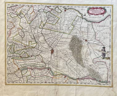
Sold2023The Netherlands Map. The region Around the city of Utrecht. 1660?s by W. BlaeuTitle: The Netherlands Map. The region Around the city of Utrecht. 1660?s by W. Blaeu Date/Period: 1660?s Materials: Hand colored copper plate engraved Size: 22 x 19 1/2'' Netherlands regional map cenSee Sold Price
Sold2024Map of Turkey in Europe from scarce Mitchell atlas – 18531850 map of Turkey in Europe from the 1853 edition of Mitchell’s New Universal Atlas. Basically a map of the Ottoman Empire, it covers modern Turkey, Greece, Croatia, Romania, Bulgaria, Bosnia,See Sold Price
Sold2018Tallis/Rapkin: Antique Map of Turkey in Europe, 1851TITLE/CONTENT OF MAP: 'Turkey in Europe' Vignettes: The Bosphorus and Constantinople; Ali Pasha; Greek Caloyer. The Balkans: Rumilia, Macedonia, Albania, Wallachia, Moldavia, Bulgaria, Servia, Bosnia,See Sold Price
Sold2021Two Early Maps of PolandA map of Poland and Silesia, by W. & J. Blaeu circa 1640 and a map of Poland - Grodków and Nysa by J. Blaeu circa 1660. Dimensions: The frames are 17" x 23" and 19" x 23".See Sold Price
Sold2021Rare BLAEU, WILLEM. 1571-1638 Map Hand Colored....Rare BLAEU, WILLEM. 1571-1638 Map Hand Colored. Insulae Americanae in Oceano Septentrionali, Cum Terris adjacentibus. Amsterdam: [1635 or later]. (Measures Frame Size 19.5" x 25" and Map Size Approx 1See Sold Price
Sold2022Blaeu's carte-à-figures map of AmericasHeading: (Maps) Author: Blaeu, Willem Title: Americæ nova Tabula Place Published: Amsterdam Publisher: Date Published: 1617-[1635] Description: Copper-engraved map, hand-coloredSee Sold Price
2022Blaeu, Johannes (Netherlands, 1596-1673) "The New World Map" Double Hemisphere World Map C. 1664Nova et Accuratissima Totius Terrarum Orbis Tabula Translated "The New World Map", Hand Colored w/ Elaborately Decorated Spandrels.   Sight View 16" x 21-1/2", Overall View 21" x 25-1/2"See Sold Price
Jun 22Willis Henry Auctions Inc.TWO HAND-PAINTED FLOOR MATS 20th c. prepared heavy canvas, painted and stenciled with the "Tree of$150
6 days LeftForum AuctionsChina.- Jansson (Jan) China Veteribus Sinarum Regio nunc Incolis Tame dicta, engraved map, [c. 1635]£200
Jun 14DuMouchellesWilliam H. Gamble (American, B. 1863) Hand Colored Engraving, Ca. 1863, "County Map of Michigan And$50(1 bid)
12 hrs LeftFreeman's | Hindman[MAP]. TODESCHI, Pietro. [Nova et Acurata Totius Americae Tabula auct. G.I. Blaeu] America quarta$5,000
Jun 14DuMouchellesRigobert Bonne (French, 1727-1794) Hand Colored Engraving Ca. 18th Century, Les Etats Unis De$50(1 bid)
4 days LeftWinter Associates Three historical engraved maps of the Caribbean, ranging from 1616-1814, each hand colored, framed$100(1 bid)
7 days LeftSwann Auction Galleries(PICTORIAL MAPS.) Two early twentieth-century pictorial maps of Santa Barbara, California.$450
Jun 14DuMouchellesRembrandt Van Rijn (Dutch, 1606-1669) Etching And Drypoint 1635, "Christ Driving the Money Changers$3,750
Jun 15Crescent City Auction GalleryPair of New Orleans Sanborn Fire Insurance Mock-Up Skeleton Maps of the French Quarter, 1910-1911,$250
1 day LeftBrzostek’s Auction Service, Inc.Antique Seneca-Cayuga Wall map 1859 by Arz Dawson, Philadelphia$10
16 hrs LeftPrime Auction Gallery, Inc.Iran, Tabriz Hand Knotted Silk Large Persian Rug 'Map Of Iran'$6,000


![Rare BLAEU, WILLEM. 1571-1638 Map Hand Colored....: Rare BLAEU, WILLEM. 1571-1638 Map Hand Colored. Insulae Americanae in Oceano Septentrionali, Cum Terris adjacentibus. Amsterdam: [1635 or later]. (Measures Frame Size 19.5" x 25" and Map Size Approx 1](https://p1.liveauctioneers.com/7170/206903/105467557_1_x.jpg?height=310&quality=70&version=1624450453)
![Blaeu's carte-à-figures map of Americas: Heading: (Maps) Author: Blaeu, Willem Title: Americæ nova Tabula Place Published: Amsterdam Publisher: Date Published: 1617-[1635] Description: Copper-engraved map, hand-colored](https://p1.liveauctioneers.com/642/234645/121524371_1_x.jpg?height=310&quality=70&version=1643052520)


![China.- Jansson (Jan) China Veteribus Sinarum Regio nunc Incolis Tame dicta, engraved map, [c. 1635] (1 of 1)](https://p1.liveauctioneers.com/5458/332455/179303772_1_x.jpg?height=282&quality=70&version=1717586421)


![[MAP]. TODESCHI, Pietro. [Nova et Acurata Totius Americae Tabula auct. G.I. Blaeu] America quarta (1 of 1)](https://p1.liveauctioneers.com/197/329395/177650542_1_x.jpg?height=282&quality=70&version=1715364962)


![Western US Map, 1857 [181625] (1 of 3)](https://p1.liveauctioneers.com/2699/331495/178785798_1_x.jpg?height=282&quality=70&version=1717094933)


