Sold2018Blaeu Map of Europe -- Europa Recens DescriptaTitle/Content of Map: Blaeu Map of Europe -- Europa Recens Descripta Date: 1635, Amsterdam Cartographer: W Blaeau Size: 16.1 X 21.9 in. This is a grand, large, classic map of Europe, produced at the gSee Sold Price
Sold2021Antique Framed Map of Europe, Europa Guilielmo BlaeuwAntique Color Map of Europe, Dutch Cartography. "Europa Recens Descripta" by Guilielmo Blaeuw, a cartographer for the Dutch East India Company. Lots of colorful detail of different nationalitiSee Sold Price
Sold2021BLAEU, Willem Europa Recens Descripta. The Netherlands,BLAEU, Willem Europa Recens Descripta. The Netherlands, 1617. A 20th century facsimile of a later impression of the third state of the original, 1617 map. Hand colored with decorative borders after thSee Sold Price
Sold2023Map of Europe 1619 – 1672 with towns and costumesDescription: Map of Europe 1619 – 1672 with towns and costumes / EUROPA RECENS DEFERIPTA.Measurement approximate:Material: PaperSee Sold Price
Sold20231743 Homann Map of Europe -- Europa Secundum Legitimas Projectionis Stereographicae Regulas et JuxtaTitle: 1743 Homann Map of Europe -- Europa Secundum Legitimas Projectionis Stereographicae Regulas et Juxta Recentissimas Observationes Aeque ac Relationes… Cartographer: J. Homann Year / Place: 174See Sold Price
Sold20211598 Munster / Petri Map of Europe -- Europa das einTitle: 1598 Munster / Petri Map of Europe -- Europa das ein Drittheil der Erden nach gelegenheit unserer zeit beschrieben Cartographer: Munster / Petri Year/Place: 1598 c., Basel Map Dimensions (in.):See Sold Price
Sold2021WILLEM BLAEU Map of Europe Offset LithographWILLEM BLAEU Map of Europe Offset Lithograph, inscriptions to piece in Latin, a map of Europe with representations of its people to border, measures 20 5/8 x 24 5/8 inches, wooden frame, surface wearSee Sold Price
Sold2017Homann: Map of Europe, 1743Map: 1743 Homann Map of Europe -- Europa Secundum Legitimas Projectionis Stereographicae Regulas et Juxta Recentissimas Observationes Aeque ac Relationes… Cartographer: J. Homann Year / Place: 1743See Sold Price
Sold2018Blaeu: Antique Map of Europe, 1650Title/Content of Map: Highly decorative Map by Blaeu Date Printed: c1650 Cartographer: W. Blaeu Material/Medium: Paper Size: 19" x 24" Hand colored engraved Map. French text on Verso. Magnificent examSee Sold Price
Sold2024Vintage William Blaeu Colored Map of EuropeVintage William Blaeu Colored Print Map of Europe, Framed. Measures 28 inches x 23 inches.See Sold Price
Sold2024L'Europa. Europe. DE ROSSI 1677 old antique vintage map plan chartTITLE/CONTENT OF MAP: L'Europa [Europe] DATE PRINTED: 1677 IMAGE SIZE: Approx 44.0 x 56.5cm, 17.25 x 22.25 inches (Large) TYPE: Antique 17th century folio atlas map CONDITION: Good; suitable for framiSee Sold Price
Sold2020[SEUTTER, M] 52 Maps of Europe sold togetherSEUTTER,M. 52 Maps of Europe sold together. ca. 1700. Includes. Europa ** Flandria ** Hanoniae ** Belgii **Luxemburg ** Dauphine Five Delpinatus ** Parmensis Et Placentinus ** Transylvaniae ** DucatusSee Sold Price
Sold2021Eleven Antique Maps of EuropeEleven Antique Maps of Europe , 16th-18th c., incl. Ptolemy from 1541 (4); a Blaeu map of "Regno di Napoli", Hondius map of the Holy Land, de Wit map of Southern Spain, an undated manuscript map of MeSee Sold Price
Sold2017Homann: Antique Map of SouthEast Europe, 1753Title/Content of Map: 1753 Homann Map os the Danube and SouthEast Europe -- Fluviorum in Europa principis Danubii cum adiacentibus Regnis nec non totius Graeciae et Archipelagi Novissima Tabula Date PSee Sold Price
Sold2021Antique Map ETHNOGRAPHISCHE KARTE VON EUROPA, J. MeyerAntique Map ETHNOGRAPHISCHE KARTE VON EUROPA (German)(Translated: Ethnographic Map of Europe), Joseph Meyer (1796-1856) | Map shows the various races/peoples as they are spread throughout Europe. ThisSee Sold Price
Sold2017Map of Europe, 1879 by Justus Perthes, Gotha, GermanyEuropa In the scale of 1.15.000.000. Published. 1879. Gotha. Germany By A. Petermann. Justus Perthes, Adolf Stieler. Handatlas uber alle Theile der Erde und uber das Weltgebaude. Adolf Stieler, GothaSee Sold Price
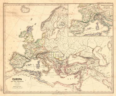
Sold2018Menke: Antique Map of Europe at time of OdovacarsTitle/Content of Map: Europa Zur Zeit Odovacars (476-493.) Date Printed: 1874 Cartographer: MENKE, TH. Publisher: JUSTUS PERTHES 1874 GOTHA Size: Quarto – 12.80 H x 15.75 W Inches "Von Th. Menke..."See Sold Price
Sold2023"Europa das ein Drittheil der Erden nach Gelegenheit unsern Zeiten", Sebastian Munster, ca. 1569"Europa das ein Drittheil der Erden nach Gelegenheit unsern Zeiten". (First Map of the Continent of Europe). Basle, ca. 1569. Sebastian Munster (German 1488-1552), was a cartographer, cosmographer, anSee Sold Price
Sold2022L'Europa divisa ne'suoi principali stati. Europe. ZATTA 1779 old antique mapTITLE/CONTENT OF MAP: 'L'Europa divisa ne'suoi principali stati' Europe divided into its main states DATE PRINTED: Published in 1779. Engraved in 1777 (this date is printed on the map). IMAGE SIZE: ApSee Sold Price
Sold2023Map of the Turkish Empire in Europe by J. Walch - 1812 engravingMap of the Turkish Empire in Europe. Title: Karte von dem Türkischen Reiche in Europa Engraver and cartographer: Johannes Walch (25 November, 1757 - 23 March, 1815). Description: handcolored engrSee Sold Price
Sold2023[MAP] SEUTTER, M. EUROPA RELIGIONIS CHRISTIANAESeutter, Matthaus. EUROPA RELIGIONIS CHRISTIANAE MORUM ET PACIS AC BELLI ARTIUM CULTU Omnium Terrarum Orbis Partium Praestantiss... [EUROPE OF THE CHRISTIAN RELIGION OF MANNERS AND OF PEACE AND THE ARSee Sold Price
Sold2024Willem Blaeu, Map of The AmericasAmsterdam, 1617. Together with "Early Maps" by Tony Campbell, Abbeville Press and "The United States in Old Maps and Prints, Eduard Van Ermen. 3 pieces Sight size: 16-1/2"h x 22"w Overall: 23-1/2"h xSee Sold Price
Sold2019Wilem J. Blaeu mapWilem J. Blaeu (Dutch 1571-1638)- Americae Nova Tabula- engraved map with hand-coloring, ca. 1633. 16 1/4 x 21 1/2''See Sold Price
Sold2017Blaeu Map of BrazilMaritima Brasiliae Universa. Joan Blaeu (1596-1673). Engraved map with original color in part. Amsterdam: Blaeu, 1647. 21 x 24 1/2 inches sheet, 32 1/2 x 36 inches framed. This separately issued and rSee Sold Price
2 days LeftPotter & Potter AuctionsGEESINK, Joop (1913 – 1984). Europa. 1957. Netherlands: KLM...$100
1 day LeftJasper52Turchia d'Europa… Turkey in Europe. Balkans Greece Bulgaria &c. ZATTA 1783 map$55
Featured1 day LeftJasper52EUROPE. Political. Austro-Hungarian Monarchy. Shipping routes. JOHNSTON 1906 map$20
1 day LeftJasper52Iles Baléares et Sardaigne #25 W. Med Sardinia Balearics VANDERMAELEN 1827 map$60
1 day LeftJasper52Decorative copperplate map of EUROPE by George A COOKE with original colour 1817$60
1 day LeftJasper52South-west & Central Europe. Switzerland includes Haute-Savoie. THOMSON 1830 map$100
1 day LeftJasper52EUROPE. Austrian Empire Prussia Poland. Slave market pic. RAPKIN/TALLIS 1851 map$100
1 day LeftJasper52Europe. Austria-Hungary. East Roumelia. Ticino shown as Italian. HUGHES 1876 map$20


![L'Europa. Europe. DE ROSSI 1677 old antique vintage map plan chart: TITLE/CONTENT OF MAP: L'Europa [Europe] DATE PRINTED: 1677 IMAGE SIZE: Approx 44.0 x 56.5cm, 17.25 x 22.25 inches (Large) TYPE: Antique 17th century folio atlas map CONDITION: Good; suitable for frami](https://p1.liveauctioneers.com/5584/322790/173578184_1_x.jpg?height=310&quality=70&version=1710881198)
![[SEUTTER, M] 52 Maps of Europe sold together: SEUTTER,M. 52 Maps of Europe sold together. ca. 1700. Includes. Europa ** Flandria ** Hanoniae ** Belgii **Luxemburg ** Dauphine Five Delpinatus ** Parmensis Et Placentinus ** Transylvaniae ** Ducatus](https://p1.liveauctioneers.com/1124/187577/94368891_1_x.jpg?height=310&quality=70&version=1607095126)


![[MAP] SEUTTER, M. EUROPA RELIGIONIS CHRISTIANAE: Seutter, Matthaus. EUROPA RELIGIONIS CHRISTIANAE MORUM ET PACIS AC BELLI ARTIUM CULTU Omnium Terrarum Orbis Partium Praestantiss... [EUROPE OF THE CHRISTIAN RELIGION OF MANNERS AND OF PEACE AND THE AR](https://p1.liveauctioneers.com/8124/310027/165853626_1_x.jpg?height=310&quality=70&version=1700184289)


