Sold2023Atoll of Menchikoff. Marshall Islands. Kwajalein Atoll. Sketch map 1886TITLE/CONTENT OF MAP: 'Atoll of Menchikoff' DATE PRINTED: 1886 IMAGE SIZE: Approx 9.0 x 11.0cm, 3.5 x 4.25 inches (Small) TYPE: Antique engraved sketch map CONDITION: Good; suitable for framing. PleasSee Sold Price
Sold2023Atoll of Ebon. Pacific Ocean. Marshall Islands. Sketch map 1886 oldTITLE/CONTENT OF MAP: 'Atoll of Ebon' DATE PRINTED: 1886 IMAGE SIZE: Approx 11.5 x 11.5cm, 4.5 x 4.5 inches (Small) TYPE: Antique engraved sketch map CONDITION: Good; suitable for framing. Please checSee Sold Price
Sold202370304: A Marshall Islands Navigation Map Micronesia, 1A Marshall Islands Navigation Map Micronesia, 19th century Constructed of coconut palm leaf midribs and shells. Such maps or charts were for navigating specific atolls and islands in MicrSee Sold Price
Sold2022Standing Oceanic Figure, Nukuoro Atoll, Caroline Islands 20th CenturyStanding Figure, Nukuoro Atoll, Caroline Islands 20th Century. Measure 11 1/4" Tall. Please carefully read our terms of sale, shipping information, and request any condition reports or photos prior toSee Sold Price
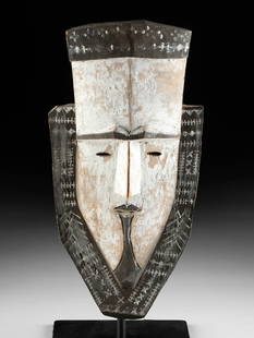
Sold202320th C. Micronesian Wood Ancestor Mask (Tapuanu)Oceania, Micronesia, Chuuk, Caroline Islands, Nomoi Islands (Mortlock), Satoan Atoll (Satawan Atoll), ca. 20th century CE. Micronesian culture has almost no masks - only those from this group of islanSee Sold Price
Sold2021Nissan Island Fish Basket, PNG, Early/Mid 20th C.Nissan Island Fish Basket, PNG, Early-Mid 20th C. Nissan is a small coral atoll that lies between the southern tip of New Ireland and Buka Island of the North Solomon Islands. Women used these basketsSee Sold Price
Sold2020Herb Kane (1928 - 2011) "Marshall Islands Christmas"Herb Kawainui Kane (Hawaii, Illinois, 1928 - 2011) Original Acrylic painting on Illustration Board titled, "Marshall Islands Christmas Carolers" Signed lower left. Original Acrylic painting on IllustrSee Sold Price
Sold2021Rare 19th C. Marshall Islands Carved Shell Fishing Lure**Originally Listed At $1800** South Pacific, Micronesia, Marshall Islands, ca. 19th century CE. A wonderful and rare example of a fishing lure that is hand-carved from pearlescent shell. The slenderSee Sold Price
Sold2016Caribbean Island Map, by Mount & Page, 1720 (rare &Spectacular sea chart of the Spanish Main to Puerto Rico, from Mount & Page's English Pilot, Fourth Book. Known as the most important English Atlas of Sea Chart covering the Mediterranean and North AmSee Sold Price
Sold2023Vintage 14K Gold Nantucket Island Map Pendant NecklaceVintage 14K Gold Nantucket Island Map Pendant Necklace, the reverse marked "14K", the chain marked "Italy 14K Aurea". Chain length 14 in. Width of pendant .9 in. Weight 3.7 dwt.See Sold Price
Sold2022Return of the Native first edition in book formHeading: Author: Hardy, Thomas Title: The Return of the Native Place Published: London Publisher:Smith, Elder, & Co. Date Published: 1878 Description: 3 volumes. FrontispieSee Sold Price
Sold2021Select Lot of Better Stamps.U.S. and Foreign. Includes #1 Nice Copy Used, Marshall Islands #25 VF OG, Germany 46b, US 4OL1 VF, US 219 de, 220d, Saxony 14 used, Reunion C! VF OG Signed, Danzig #32 with certificate, Great BritainSee Sold Price
Sold202119th C. Micronesian Mother of Pearl Fish Hook w/ SennitMicronesia, Marshall Islands, ca. 19th to early 20th century CE. A huge mother of pearl shell fish hook, made of two pieces - one larger and broader, the other smaller and sharper - tightly bound togeSee Sold Price
Sold2024LADIES LARGE OVAL NANTUCKET BASKET PURSE DECORATED WITH TWO WHALES BY DONNA CIFRANIC (1936-2022)Traditionally made, featuring Mother & Young Whales signed "Donna Cifranic, Nantucket Island, 1886". Swivel bale handle, 7" x 11 1/2" x 8" body, 7 1/2" tall handle. Fine condition.Donna Cifranic and hSee Sold Price
Sold2023HAROLD GIBBS MINIATURE WOODCOCK Barrington, Rhode Island, 1886-1970 Height 2".HAROLD GIBBS MINIATURE WOODCOCKBarrington, Rhode Island, 1886-1970Mounted on a driftwood base. Signed and dated on underside "repaired 1968 H. Gibbs".Height 2".See Sold Price
Sold2024Antique Treasure Island Reverse Glass Banjo Clock.Made by the Ingraham Clock works in Bristol Connecticut. Wood case with metal face and reverse glass island map and pirate scenes. Clock and chime works but needs adjustment of time. Gold painted eaglSee Sold Price
Sold20201886 Map of Indian NationsAuthor: Clare Title: 1886 Map of Indian Nations Medium: Ink on Paper Dimensions: 14.5"X11" Description: Map dated 1886 part of Watson's General Atlast. Engraved by I.S. Clare it captures the Indian NaSee Sold Price
Sold2021Oyvind Fahlstrom, Sketch for World Map, ScreenprintArtist: Oyvind Fahlstrom, Swedish (1928 - 1976) Title: Sketch for World Map Portfolio: Peace Year: 1972 Medium: Screenprint, Signed and numbered in pencil Edition: 150 Size: 33 in. x 41.5 in. (83.82 cSee Sold Price
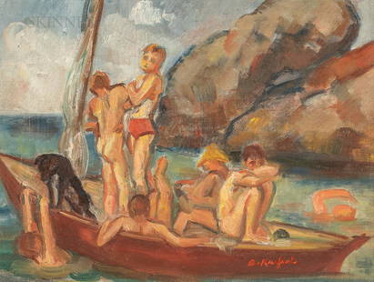
Sold2021Bernard Karfiol (American, 1886-1952)Bernard Karfiol (American, 1886-1952) Sketch for Boys in Boat (Ogunquit) Signed "B. Karfiol" l.r., titled in an inscription on the reverse, dated "c. 1949" on a label from The DowntowSee Sold Price
Sold2024Rapkin, John 1860 Antique Map. West India IslandsSteel Engraved Map Published 1860 by The London Printing & Published Company, London for "The Royal Dictionary-Cyclopedia for Universal Reference" by Thomas Wright. Drawn & Engraved by John Rapkin. FoSee Sold Price
Sold2022ATTRIBUTED TO WILLIAM TROST RICHARDS (Pennsylvania/Rhode Island, 19th Century), "Beach Sketch"., OilATTRIBUTED TO WILLIAM TROST RICHARDSPennsylvania/Rhode Island, 19th Century"Beach Sketch". Unsigned. Inscribed verso "Beach Sketch" and "Provenance: Painted by my GrandfatherSee Sold Price
Sold2021[HAWAII] Dole Pictorial Map of the Hawaiian Islands.[HAWAII] Dole Pictorial Map of the Hawaiian Islands. 1937. Offset lithograph. Scarce pre-war pictorial map of the islands, filled with vignettes of the natural and man-made landmarks, modes of transpoSee Sold Price
Sold2018Ortelius: Composite Map of Cyprus / Aegean Islands 1584Insular. Aliquot Aegaei Maris Antiqua Descrip. The superb Ortelius map of Cyprus surrounded by nine smaller maps of Aegean islands (including Rhodes, Chios, Samos, Lesbos), from the Latin edition of tSee Sold Price
Sold2018Large Framed 1794 Map of America Laurie & Whittle1794, London New Map of America & The West India Islands. With detailed side maps of California, and Baffin & Hudson Bay. Published by Laurie and Whittle. Map measures approximately 43.5" L x 49.5" H,See Sold Price
4 days LeftJasper52Orient. Western Pacific Islands. Fiji Tonga Melanesia Micronesia. TIMES 1958 map$30
Featured4 days LeftJasper52Arid Regions and Closed River Basins of Asia. Sketch map 1885 old antique$8
May 30Forum AuctionsAmerica.- California gold mining.- Palmer (N.S.) Autograph Letter signed to his brother on mining£400
Jun 07Freeman's | HindmanHARDY, Thomas. The Return of the Native. 1878. FIRST EDITION IN BOOK FORM, FIRST ISSUE.$500
Jun 07Freeman's | Hindman[ATOMIC BOMB]. A group of 8 images relating to nuclear tests. 1945-1957 (printed 2009).$350
4 days LeftJasper52ASIA."Hindostan" Pegu Niphon Persia Anam Siam "Abou Thubbi" (Abu Dhabi) 1886 map$20


![[HAWAII] Dole Pictorial Map of the Hawaiian Islands.: [HAWAII] Dole Pictorial Map of the Hawaiian Islands. 1937. Offset lithograph. Scarce pre-war pictorial map of the islands, filled with vignettes of the natural and man-made landmarks, modes of transpo](https://p1.liveauctioneers.com/928/200564/101543113_1_x.jpg?height=310&quality=70&version=1618323144)


![[ATOMIC BOMB]. A group of 8 images relating to nuclear tests. 1945-1957 (printed 2009). (1 of 3)](https://p1.liveauctioneers.com/197/329395/177650227_1_x.jpg?height=282&quality=70&version=1715364962)


