Sold2018ANTIQUE HAND COLORED WORLD MAP WITH SCENIC CORNERS.ANTIQUE HAND COLORED WORLD MAP WITH SCENIC CORNERS ON EARLY LAID PAPER. IMAGE 22 3/4 X 19 1/4See Sold Price
Sold2021Antique Map Lithographs New York City, World MapPair Antique Hand Colored Map Lithographs of New York City, and a World Map. Unframed 18 inches x 23 inchesSee Sold Price
Sold2018Zurner: Antique Map of the World, 1700Title/Content of Map: World Map by Zurner Date Printed: c1700 Cartographer: A.F. Zurner Material/Medium: Paper Size: 20" x 21" Rare world Map. Hand colored engraved. Please note that this lot has a coSee Sold Price
Sold2022Antique World Map - Colored Etching Pre 1775World Map. Due to laid paper technique, we believe it may be pre-1775. This map is based on the 1594 world map by Peter Plancius, but what draws the eye are the lively figures depicted in the corner sSee Sold Price
Sold2022Antique Map Print - Map of Bohemia - Map of Czech Republic - KingdomAntique outline hand colored map from edition of Meyer’s world atlas, edited by Ludwig Ravenstein, published by Bibliographic Institute in 1872. Technique: Engraving. Place: Leipzig, Germany. SSee Sold Price
Sold2022Original Antique Map -Pommern Provinz - Map of Bornholm Island Baltic SeaAntique outline hand colored map from edition of Meyer’s world atlas, edited by Ludwig Ravenstein, published by Bibliographic Institute in 1872. Technique: Engraving. Place: Leipzig, Germany. SSee Sold Price
Sold2022Original Antique Map - Mecklenburg-Schwerin - Map of Northern GermanyAntique outline hand colored map from edition of Meyer’s world atlas, edited by Ludwig Ravenstein, published by Bibliographic Institute in 1872. Technique: Engraving. Place: Leipzig, Germany. SSee Sold Price
Sold2022Original Antique Map -Bremen Oldenburg - Map of Bremen OldenburgAntique outline hand colored map from edition of Meyer’s world atlas, edited by Ludwig Ravenstein, published by Bibliographic Institute in 1872. Technique: Engraving. Place: Leipzig, Germany. SSee Sold Price
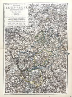
Sold2022Original Antique Map -Hessen Nassau - Map of Furstenthum WaldeckAntique outline hand colored map from edition of Meyer’s world atlas, edited by Ludwig Ravenstein, published by Bibliographic Institute in 1872. Technique: Engraving. Place: Leipzig, Germany. SSee Sold Price
Sold2022Antique Map Print - Map of Schleswig - Holstein - Map of Germany - LauenburgAntique outline hand colored map from edition of Meyer’s world atlas, edited by Ludwig Ravenstein, published by Bibliographic Institute in 1872. Technique: Engraving. Place: Leipzig, Germany. SSee Sold Price
Sold2022Antique Map Print - Map of Mecklenburg-Schwerin - Map of Germany - Roman EmpireAntique outline hand colored map from edition of Meyer’s world atlas, edited by Ludwig Ravenstein, published by Bibliographic Institute in 1872. Technique: Engraving. Place: Leipzig, Germany. SSee Sold Price
Sold2022Original Antique Map - Konicreich Bohmen - Map of Bohmen - Prague - CarlsbadAntique outline hand colored map from edition of Meyer’s world atlas, edited by Ludwig Ravenstein, published by Bibliographic Institute in 1872. Technique: Engraving. Place: Leipzig, Germany. SSee Sold Price
Sold2022Antique Map Print - Map of Rheinprovinz - Map of Germany - Prussian StateAntique outline hand colored map from edition of Meyer’s world atlas, edited by Ludwig Ravenstein, published by Bibliographic Institute in 1872. Technique: Engraving. Place: Leipzig, Germany. SSee Sold Price
Sold2022Antique Map Print - Map of Pomerania - Map of Germany - South of the Baltic SeaAntique outline hand colored map from edition of Meyer’s world atlas, edited by Ludwig Ravenstein, published by Bibliographic Institute in 1872. Technique: Engraving. Place: Leipzig, Germany. SSee Sold Price
Sold2022Antique Map Print - Map of Oldenburg - Map of Germany - Lower Saxony - HunteAntique outline hand colored map from edition of Meyer’s world atlas, edited by Ludwig Ravenstein, published by Bibliographic Institute in 1872. Technique: Engraving. Place: Leipzig, Germany. SSee Sold Price
Sold2022Antique Map Print - Map of Hesja-Nassau - Map of Austria - Prussian ProvinceAntique outline hand colored map from edition of Meyer’s world atlas, edited by Ludwig Ravenstein, published by Bibliographic Institute in 1872. Technique: Engraving. Place: Leipzig, Germany. SSee Sold Price
Sold2023B.R.Davies Hand Colored Antique Venice Italy MapMarked on backside Authentic Antique Print, date London c.1840 Medium. Hand colored engraving, artist, B.R. Davies. Marked on lower right corner engraved by B.R.Davies, drawn by WB Clarke. Reads VenicSee Sold Price
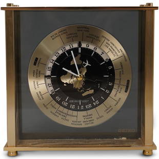
Sold2020Seiko World Desk ClockDESCRIPTION: A Seiko desk clock. Features a world map dial with white colored hands and airplane motif seconds hand. Marked "Seiko, Quartz Japan" Finished with time zone markers and a gilt brass case.See Sold Price
Sold2023Antique Map Print - Map of World - Scheme of Oceanic and Continental BasinsDescription: This vibrant hand-colored map of the world was published in Chicago by Rand McNally in the last quarter of the 19th century for inclusion in the company’s geography textbook, McNallSee Sold Price
Sold20211650 Insularum Archipelagi Septentrion Alis Seu MarisBy: Jan JanssonDate: 1650 (circa) AmsterdamDimensions: 18.75 x 22.25 inches (48 cm x 57 cm)This authentic antique hand-colored map by Jan Jansson depicts the Northern Archipelago in Greece with the AeSee Sold Price
Sold20211650 Achaiae Noua & Descriptio Autore I. LaurenbergioBy: Jan JanssonDate: 1650 (circa) AmsterdamDimensions: 15.25 x 22.25 inches (39 cm x 56.5 cm)This authentic antique hand-colored map by Jan Jansson depicts Achaiae and a major portion of the PeloponneSee Sold Price
Sold20201699 D’Eilanden van Capo Verde, de Kust en’t Landt derThis attractive antique hand-colored map features the Cape Verde Islands off the west coast of Africa, and a portion of the coast of western Africa including Muritaniya, Cape Verde, Gambia, and SenegaSee Sold Price
Sold20201699 De zeventien Nederlantsche Provintien; niewelyksThis attractive antique hand-colored map features the seventeen provinces of the Netherlands as they appeared at the end of the seventeenth century. Sanson's compass rose orients the map west. HistoriSee Sold Price
Sold2021Four Antique Hand Colored MapsA grouping of four small framed hand-colored engraved maps to include New England and New York by John Seller, A Mapp of the World by John Seller, Terra Firma, and Moscovia (Moscow) of Russia. All inSee Sold Price
May 26Ararity AuctionsThomson's 1817 Hand Colored Map Comparative Heights of the World's Great Mountains$50
18 hrs LeftAlbion AuctionsMarmocchi, F. C. 1845 Hand Col Map. Judaica - Jewish World & Israelites Camp$5
2 days LeftTrillium Antique Prints & Rare BooksBraun & Hogenberg, pub. 1575 - View of Chios, Greece$120(2 bids)
2 days LeftTrillium Antique Prints & Rare BooksBraun & Hogenberg, pub. 1575 - Lower View of Rome, Italy$100
2 days LeftTrillium Antique Prints & Rare BooksBraun & Hogenberg, pub. 1575 - Views of Copenhagen, Denmark$100
2 days LeftTrillium Antique Prints & Rare BooksBraun & Hogenberg, pub. 1575 - View of Granata (Granada), Spain$100
2 days LeftTrillium Antique Prints & Rare BooksBraun & Hogenberg, pub. 1575 - View of Perugia, Italy$100
2 days LeftTrillium Antique Prints & Rare BooksBraun & Hogenberg, pub. 1575 - View of Dordrecht, Netherlands$100
May 26Ararity AuctionsC. G. Reichard "Charte des Osmanische Reichs in Asien" 1804 Antique Hand Colored Framed Map$50
18 hrs LeftAlbion AuctionsPrichard & Walker 1844 Hand Colored Map. Ethnological Map of Asia$15(2 bids)
5 days LeftHess Fine AuctionsAntique Mid Victorian Hand Colored Portrait Engraving Transitional Empire To Victorian France$10