Sold2022Antique Map Print - Map of Pomerania - Map of Germany - South of the Baltic SeaAntique outline hand colored map from edition of Meyer’s world atlas, edited by Ludwig Ravenstein, published by Bibliographic Institute in 1872. Technique: Engraving. Place: Leipzig, Germany. SSee Sold Price
Sold2022Original Antique Map -Pommern Provinz - Map of Bornholm Island Baltic SeaAntique outline hand colored map from edition of Meyer’s world atlas, edited by Ludwig Ravenstein, published by Bibliographic Institute in 1872. Technique: Engraving. Place: Leipzig, Germany. SSee Sold Price
Sold2018Bonne: Antique Map of Central Europe, 1780Title/Content of Map: 'L'Allemagne, La Boheme, et La Hongrie; avec une partie de Pologne'. A map of Central Europe from the Baltic Sea to the Gulf of Venice, including present day Germany, Poland, CzeSee Sold Price
Sold20221710 antique MAP of PRUSSIA POLAND BALTIC REGION Dantzig & Koenigsberg 18th centMap of the Prussia, the Baltic region, extends from Memel ( Klaipeda ) to Pomerania, extending south to Poland. Centered on Dantzig and Konigsberg. The title scroll features a portrait of Frederick IISee Sold Price
Sold2022Antique Map Print - Map of Mecklenburg-Schwerin - Map of Germany - Roman EmpireAntique outline hand colored map from edition of Meyer’s world atlas, edited by Ludwig Ravenstein, published by Bibliographic Institute in 1872. Technique: Engraving. Place: Leipzig, Germany. SSee Sold Price
Sold2022Antique Map Print - Map of Rheinprovinz - Map of Germany - Prussian StateAntique outline hand colored map from edition of Meyer’s world atlas, edited by Ludwig Ravenstein, published by Bibliographic Institute in 1872. Technique: Engraving. Place: Leipzig, Germany. SSee Sold Price
Sold2022Antique Map Print - Map of Oldenburg - Map of Germany - Lower Saxony - HunteAntique outline hand colored map from edition of Meyer’s world atlas, edited by Ludwig Ravenstein, published by Bibliographic Institute in 1872. Technique: Engraving. Place: Leipzig, Germany. SSee Sold Price
Sold2022Antique Map Print - Map of Bohemia - Map of Czech Republic - KingdomAntique outline hand colored map from edition of Meyer’s world atlas, edited by Ludwig Ravenstein, published by Bibliographic Institute in 1872. Technique: Engraving. Place: Leipzig, Germany. SSee Sold Price
Sold2022Antique Map Print - South America - United StatesSet of 4 Map Prints. Antique lithographic map originates from "Letts's Popular Atlas", being a series of maps delineating the whole surface of the globe, with many special and original features; and aSee Sold Price
Sold2022Antique Map Print - South Africa - Algeria - Egypt - PalestineSet of 4 Map Prints. Antique lithographic map originates from "Letts's Popular Atlas", being a series of maps delineating the whole surface of the globe, with many special and original features; and aSee Sold Price
Sold2022Antique Map Print - Map of Schleswig - Holstein - Map of Germany - LauenburgAntique outline hand colored map from edition of Meyer’s world atlas, edited by Ludwig Ravenstein, published by Bibliographic Institute in 1872. Technique: Engraving. Place: Leipzig, Germany. SSee Sold Price
Sold2022Antique Map Print - Map of Hesja-Nassau - Map of Austria - Prussian ProvinceAntique outline hand colored map from edition of Meyer’s world atlas, edited by Ludwig Ravenstein, published by Bibliographic Institute in 1872. Technique: Engraving. Place: Leipzig, Germany. SSee Sold Price
Sold2023Antique Map Print - Europe - Map of Silesia - Poland - Czech Republic - WroclawDescription: Map of Silesia. Silesia is a historical region of Central Europe that lies mostly within Poland, with small parts in the Czech Republic and Germany. Date: 17th Century Material: Paper DimSee Sold Price
Sold2021ILN 1856 Large Ship Print & Map (Trimmed)"The Fleet of the Great Naval Review at Spithead" Together with "Picture Map of the Baltic Sea" on the reverse. Large Wood Engraving Published 1856, London for "The Illustrated London News" Folds as iSee Sold Price
Sold2022Antique Map Print - Austria - Germany - Austrian EmpireSet of 4 Map Prints. Antique lithographic map originates from "Letts's Popular Atlas", being a series of maps delineating the whole surface of the globe, with many special and original features; and aSee Sold Price
Sold20172 early maps, Chili & Auriacus Princip, by Ortelius.2 Antique Hand-Colored Map Prints, "Royaume de Chili", a miniature map of Chili, South America ; and "Auriacus Principatus" ( by Ortelius), showing the region around the Roman city of Orange in southeSee Sold Price
Sold2018Kitchin: Antique Map of Panama/Colombia/Ecuador, 1795Map: Map of the Countries on the South Sea, from Panama to Guayaquil Cartographer: Kitchin Place & Date: London / 1795 Size: 9 3/8" x 14 5/8" Condition: outline color; overall age toning; upper rightSee Sold Price
Sold2022Antique Map Print - North America - Africa - South America - WorldSet of 4 Map Prints. Hand-colored map print of the edition of 1851 from the work Universal Historical and Geographical Atlas ("Atlas Universel Historique et Geographique"). This iconic map contains diSee Sold Price
Sold2018Seutter: Antique Map of Brandenburg & Pomerania, 1740Title/Content of Map: Brandenburg & Pomerania region of Germany & Poland Date Printed: c1740 Cartographer: Matthaus Seutter Material/Medium: Paper Size: 19 1/2" x 23 3/4" Original hand colored copperpSee Sold Price
Sold2018Thomson: Antique Map of Southern Germany, 1817Title/Content of Map: 'Germany, south of the Mayne'. This large, decorative map shows Southern Germany, including the Kingdom of Bavaria, Hesse-Darmstadt, the Grand Duchy of Baden, the Kingdom of WurtSee Sold Price
Sold2023Antique Map Print - Five West Indies - North America - South America - 1701Title: Antique Map Print - Five West Indies - North America - South America - 1701 Date/Period: 1701 Dimensions: 15 cm x 13 cm Material: Paper Additional Information: A detailed small map from ”See Sold Price
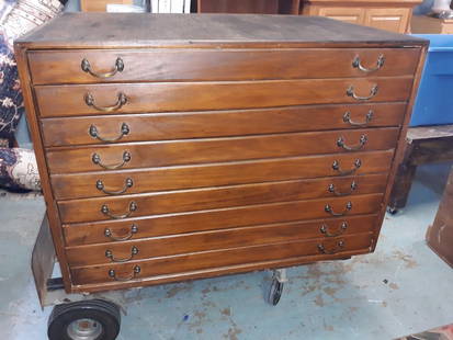
Sold2020Antique Map Architect Blue Print Sea Captain Chest 9 drAntique Map Architect Blue Print Sea Captain Chest 9 drawers custom made flat file cabinet for sea captain architect or blue prints,Maps, 9 drawers all on roller glides drawers work great very good coSee Sold Price
Sold2020Antique Map Architect Blue Print Sea Captain Chest 9 drcustom made flat file cabinet for sea captain architect or blue prints,Maps, 9 drawers all on roller glides drawers work great very good condition see all pics 34 1/2" tall x 41 1/2" wide x 28" deeploSee Sold Price
Sold2024Stieler, Adolf 1909 Antique Map. New Zealand - South Sea Islands, Pacific Australia HawaiiLithograph Map Published 1909 by Justus Perthes, Gotha for "Stielers Atlas of Modern Geography" by Adolf Stieler. Center fold as published. Paper Size: 19 x 15.5 inch (48 x 39cm) Good ConditionSee Sold Price
7 days LeftJasper52The South-West Coast of Ireland from Dungarvan to… Shannon MOUNT & PAGE 1758 map$280
7 days LeftJasper52Europe after the Congress of Vienna. 4 sheets. 128x106cm. THOMSON 1817 old map$550
7 days LeftJasper52Fusan (Busan) harbour, South Korea. ADMIRALTY sea chart 1912 (1955) old map$360(1 bid)
7 days LeftJasper52THE ENGLISH LAKE DISTRICT. Cumberland, Westmoreland & Lancashire. CARY 1832 map$280
7 days LeftJasper52MILLWALL DEPTFORD Surrey & West India Docks Isle of Dogs Canary Wharf 1900 map$260
7 days LeftJasper52WESTMINSTER Lambeth Kennington Waterloo Vauxhall Oval Pimlico Lambeth 1900 map$280
7 days LeftJasper52HAMMERSMITH & FULHAM Castlenau West Kensington Barons Court Earls Court 1900 map$320
7 days LeftJasper52Chart of the Newcastle Trade describing… coast of England. MOUNT & PAGE 1758 map$550
7 days LeftJasper52South Coast of England. 175x65cm. Imray Laurie Norie Wilson sea chart 1913 map$280