Sold20222-Clason Road Maps & American Insurance Maprated 6 to 8, 7"x4" or less in size, Nebraska is in very good condition, Arizona has light wear, Iowa is soiled.See Sold Price
Sold20222 Maps from WW1 Era.Road Map of Germany dated 1918 and Mouzon Territory in Germany during WW1.See Sold Price
Sold20231736 English Road Maps Cambridge, Bath-Bristol, Lancaster- York & Knaresburg1736 Cambridge hand colored 5 x 7 in frame, Lancaster and York, Knaresburg 2 sided in open matt 5 x 7, and Bath to Bristol framed 4 x 6 inches in matt.See Sold Price
Sold20232 Maps of Delaware by Finley of Philadelphia & Lucasc.1824 Delaware Map by Anthony Finley, from A New General Atlas. Hand Colored with details of the county seats, roads, towns and settlements, and watershed. I The Cypress Swamp is well drawn along theSee Sold Price
Sold2021World War II Pictorial Battle Maps (2)VII Corps. With XIX Corps in Action From Secured Line to Victory. 2 WWII European theater maps, American troops and allies, movements with illustrations. Sights 20 1/2" x 27 1/2", overall 22" x 29".See Sold Price
Sold2017Vintage Mobil, Pure, Standard, Shell & Gulf Road s(25) Vintage Road maps printed by American Standard, Mobilgas and Mobiloil, Shell, Texaco, Pure and Gulf from CA to Ontario and many states in-between. These road maps are in good used condition. AlsoSee Sold Price
Sold2020Roadmaps and EphemeraLot includes an Esso and a Gulf map, a large selection of American and international road maps from 1960s and 1970s, Sing a Song player book with xylophone, 25c Steel Pier program, a York PA bank bag,See Sold Price
Sold2015(2pc) [INSURANCE MAPS OF GREENWICH, CONN.]published by Sanborn Map Company, 1920; plus a Greenwich real estate map, 25 3/4 x 23 1/2"See Sold Price
Sold20241908 York Pennsylvania Antique Insurance Maps"Insurance Maps of York County Pennsylvania" dated 1908 published by Sanborn Map Company. Measures 25 3/4" x 22 1/2". Scale 50ft : 1 inch. Includes corrections after publication. Not all pages verifieSee Sold Price
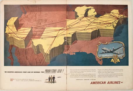
Sold20231950s American Airlines Route Map -- American Airlines Route MapTitle: 1950s American Airlines Route Map -- American Airlines Route Map Cartographer: American Airlines Year / Place: 1950s Map Dimension (in.): 12.5 X 19.2 in. joined This nice, large pictorial routeSee Sold Price
Sold2023MAPS CARTOGRAPHY ITEMS WITH 2 HAND DRAWINGSThe lot includes a framed mid century American map Penobscot Bay And Approaches, United States - East Coast - Maine, Scale 1:80 000; Raritan River From Raritan Bay to New Brunswick New Jersey, Scale 2See Sold Price
Sold2022MAPS CARTOGRAPHY ITEMS WITH 2 HAND DRAWN PIECESThe lot includes a framed mid century American map Penobscot Bay And Approaches, United States - East Coast - Maine, Scale 1:80 000; Raritan River From Raritan Bay to New Brunswick New Jersey, Scale 2See Sold Price
Sold2023Trade SignPainted wooden sign "Revolutionary War Dutch New Amsterdam New York Native American Local lore & Maps". 41 1/2" x 11 1/2".See Sold Price
Sold20242 18th C. Road Maps: London to Carlisle (14 1/2" x 17 1/2") & Bristol to Exeter, 6 1/2"2 18th C. Road Maps: London to Carlisle (14 1/2" x 17 1/2") & Bristol to Exeter, 6 1/2"See Sold Price
Sold2022(2) 18th c. road maps, London-Norwich, etc.Two hand colored maps of roads from London to Norwich, England, and from Shrewsbury to Holywell, England. A printed description in an attached envelope on the back of one states that they were made bySee Sold Price
Sold20212 Large Scrapbooks of Shell Oil 30's US Road Map BooksPair of Folio Style Shell Oil 1930s US Road Map Books. These map booklets, with tabs for various US States like North Carolina, South Carolina, Virginia, West Virginia, and Texas, were published by ShSee Sold Price
Sold20211950s Road map of Northern CaliforniaHeading: (California - Road maps) Author: Title: Road Map of California: Section 2 Place Published: San Francisco and Los Angeles Publisher:National Automobile Club Date Published: [c. 1950sSee Sold Price
Sold2022Vintage Railroad CollectiblesClason's 1919 Wisconsin Road Map & Railway Guide. This is a rare and hard to find Clason's 1919 Wisconsin Road Map and Railway Guide. It lists all of the cities and towns in Wisconsin, along with theiSee Sold Price
Sold2016Auction catalogs, Bulletin #24 O.I.C.SLot consisting of Auction catalogs, Bulletin #24 O.I.C.S. 1950, 2 Mercer Co. Road MapsSee Sold Price
Sold20221789 military map of American Northeast1789 military map of American Northeast by Thomas ConderThis map was originally in the two volume book set by Thomas Anburey in this auction, lot 144. Frame: 20" x 20" Painting: 15 1/8" x 16 1/2" ThomSee Sold Price
Sold2020NATIVE AMERICAN RESERVATION MAP, 1884 (FRAMED)Sight- 21" x 32 1/2" Overall- 28" x 39" MUST USE 3RD PARTY SHIPPERSee Sold Price
Sold2021H. GREELEY American Conflict 2 vol 1865 with large mapGREELEY, Horace (Maps) The American Conflict, 2 vols., 1865; large map. Offered by John Bale Books LLC; for more information email us at jbalebooks@gmail.com The 1865 edition of Horace Greeley’sSee Sold Price
Sold2023E. Belcher Hyde Map Co. - Maps of Suffolk, Group of 4Lot 49 E. Belcher Hyde Map Co. American Manufacturer (fl. c. 1880 - 1920) Maps of Suffolk, Group of 4 (1916) lithograph with hand coloring from Suffolk County 1916 Vol 2 Long Island, New York, includeSee Sold Price
Sold2023E. Belcher Hyde Map Co. - Maps of Sag Harbor, Group of 2Lot 48 E. Belcher Hyde Map Co. American Manufacturer (fl. c. 1880 - 1920) Maps of Sag Harbor, Group of 2 (1916) lithograph with hand coloring from Suffolk County 1916 Vol 2 Long Island, New York 17 xSee Sold Price
3 days LeftJasper521795 Lewis Map of Maryland -- The State of Maryland, from the best Authorities$360
Jun 15Crescent City Auction GalleryPair of New Orleans Sanborn Fire Insurance Mock-Up Skeleton Maps of the French Quarter, 1910-1911,$250
4 days LeftJasper52CENTRAL AMERICA.Panama Guatemala Nicaragua Costa Rica British Honduras 1952 map$15
Jun 08Early American History Auctions1853 Specialized Map, Railroads in the United States in Operation and Progress... Treasury Deptment$200(1 bid)
Jun 08Simpson Galleries, LLC.TWO AMERICAN MAPS, "Texas," AND "Mexico," J.H. COLTON, NEW YORK, CIRCA 1854-1856$150
Jun 08Early American History Auctions1720 Colonial Northumberland County Virginia Manuscript Deed and Map Plot$400
3 days LeftJasper521868 TRAVELS in EAST INDIAN ARCHIPELAG0 by ALBERT BICKMORE illustrated ANTIQUE$170(1 bid)
2 days LeftRapid Estate Liquidators and Auction GalleryDoughboys The Story of the AEF 1917-1918 Hardcover$35
Jun 12Dan Morphy AuctionsGEOLOGY OF THE BLACK AND GRAND RAPIDS OF TEXAS INCLUDING THE EASTERN AND WESTERN CROSS TIMBERS,$100


![(2pc) [INSURANCE MAPS OF GREENWICH, CONN.]: published by Sanborn Map Company, 1920; plus a Greenwich real estate map, 25 3/4 x 23 1/2"](https://p1.liveauctioneers.com/522/81470/42273580_1_x.jpg?height=310&quality=70&version=1446235682)