Sold2023E. Belcher Hyde Map Co. - Maps of Suffolk, Group of 4Lot 49 E. Belcher Hyde Map Co. American Manufacturer (fl. c. 1880 - 1920) Maps of Suffolk, Group of 4 (1916) lithograph with hand coloring from Suffolk County 1916 Vol 2 Long Island, New York, includeSee Sold Price
Sold2023E. Belcher Hyde Map Co. - Maps of Sag Harbor, Group of 2Lot 48 E. Belcher Hyde Map Co. American Manufacturer (fl. c. 1880 - 1920) Maps of Sag Harbor, Group of 2 (1916) lithograph with hand coloring from Suffolk County 1916 Vol 2 Long Island, New York 17 xSee Sold Price
Sold2016Town of Southampton Map (North Haven & Art Village),Original engraving of Southhampton town, including Peconic Bay, Hobson Island and many landmarks & family names. Published by E. Belcher Hyde from "Atlas of Suffolk County, Long Island, New York," 190See Sold Price
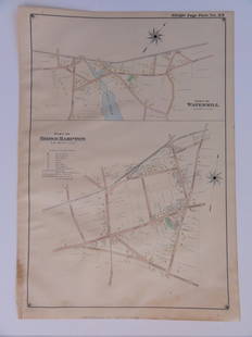
Sold2016Bridgehampton & Watermill, Long Island, 1902Original engraving published by E. Belcher Hyde from "Atlas of Suffolk County, Long Island, New York," Philadelphia, 1902. Map features family names, historic buildings and railroad routes. DimensionsSee Sold Price
Sold20241889 Ellis & Co. Map of Victoria, BC 24 3/4" x 38 1/2" (acquired Leslie E. Cook Estate 1970).1889 Ellis & Co. Map of Victoria, BC 24 3/4" x 38 1/2" (acquired Leslie E. Cook Estate 1970).See Sold Price
Sold2018GROUP LOT OF PAPER GOODS(5) INCLUDING - TWO BRUCKTOWN AND PLYMOUTH RAILWAY CO. MAPS - WIARD PLOW ADV. - "VIEWS OF FALL RIVER LINE" NEW YORK TO BOSTON - 1876 CENTENNIAL SOUVENIR, PHILADELPHIA , 3 1/4" TO 6 1/2" HSee Sold Price
Sold2020HYDE, E. BELCHER. Westchester County. State of NewHYDE, E. BELCHER. Westchester County. State of New York. Also a portion of the State of Connecticut Embracing the Towns of Greenwich, Stamford, Darien, New Canaan, Ridgefield. Large lithographed map oSee Sold Price
Sold2017Railroad Annual Passes (4)A group of 4 annual passes that includes" New York & New England 1880 - map on reverse P. W. Strader & Co 1871 - Cincinnati stage line, Jeffersonville with impossible to read lettering - very old locoSee Sold Price
Sold2023Group of 4 Early European MapsGroup of 4 early framed European maps, including; 'De L'Europe, figure III., Isle D'Albion", 'Westmorland', 'Wien in Oesterreich' and 'Milan'. Measures: 12" x 15 1/2" overall, largest.See Sold Price
Sold2021A group of 5 maps of Chicago streets, comprising:A group of 5 maps of Chicago streets, comprising: E. 1/2 of S.W 1/4 Section 8.39.14. N.P.: N.d. 31 x 40 3/4 in. -- W. 1/2 of N.W. 1/4 Section 4.39.14. Butterfields Add. N.p: N.d. 31 x 40 3/4 in. -- E.See Sold Price
Sold2019Group of Early Maps of New Mexico(1) Rand, McNally & Co.'s New Commercial Atlas of America - Map of New Mexico. Copyright, 1911, by Rand, McNally & Co. 23 3/4 x 31 1/4 inches (2) Geologic Map of New Mexico. Two-part folding map. PartSee Sold Price
Sold2017Cassini: Antique Map of Northern South America, 1798Map: La Terra Ferma e la Guiana Co' suoi departimenti Cartographer: Cassini Place & Date: Rome / 1798 Size: 14 1/4" x 19 1/4" Condition: outline color; light overall age toning; some fraying on outerSee Sold Price
Sold2023Original Vintage c. 1930s Dutch Airline Travel PosterWijga, Jan 1902 - 1978 KNILM - Complete Map of the Airlines Letterpress Print ca. 1938 22.4 x 29.9 in. (57 x 76 cm) Printer: Herdruk E. Fuhri & Co., S'Baia Condition Details: (B+) small tears, creasesSee Sold Price
Sold20201868 Guide to Chicago by Ellwood Zell & Co.1868 Guide to Chicago by Ellwood Zell & Co. The map has a 4" inch tear. Size of map is approx. 10 1/2" inches by 15 3/4" inches. In fair condition.See Sold Price
Sold2017Vintage Paper W Canvas Map of Suffolk CoVintage Paper W Canvas Map of Suffolk Co. Reads as the 'Map of Suffolk. Co. L.I. New York." Also reads published by John a Douglas. Some stains on canvas and wear to paper. Printed Paper map mounted oSee Sold Price
Sold2022Large Group of Books, Engravings, and Etchings, toLarge Group of Books, Engravings, and Etchings, to include Atlas of the Borough of Brooklyn, volume two by E. Belcher Hyde 1917; three volume set of The National Shakespeare; leather bound Holy Bible;See Sold Price
Sold2022Vintage 1950 Chas. E. Shannahan Talbot Co. Maryland Mapmeasuring 25" x 28" high framed 1950 Talbot County, Maryland Map mounted on linen with pencil notes written on right hand side. "Seats of Talbot County" #41 of 100 copies made.See Sold Price
Sold2016LARGE FORMAT SANBORN MAP BOOK OF KINGSTON NY APRIL 1899LARGE FORMAT SANBORN MAP BOOK OF KINGSTON NY APRIL 1899 WITH NEW ADDITIONAL INDEXES UP TO DEC 1952, AND BOOKLET ON HOW TO USE MAP, BOOK MEASURES 25 3/4 " X 23 1/2", SANBORN MAP CO, PELHAM NY, OUTER BOSee Sold Price
Sold2020Antique Picot & Co map of England and WalesAntique Picot & Co framed map of England and Wales with part of Scotland. Overall size 37"h x 31"w overall. Paper sight size 27 1/2"h x 21 1/4"w. Published by Picot & Co London and Manchester.See Sold Price
Sold20241850 Thomas, Cowperthwait & Co. Map of New York -- City of New-YorkTitle: 1850 Thomas, Cowperthwait & Co. Map of New York -- City of New-York Cartographer: Thomas, Cowperthwait & Co. Year / Place: 1850. Philadelphia Map Dimension (in.): 15.5 X 12. 4 in. This is map oSee Sold Price
Sold2023GROUP OF BOOKS ON BOSTON ARCHITECTURE & HISTORYBoston Landmarks; Ross, The Book of Boston: The Federal Period; Whitehill, Boston: A Topographical History; Ross, The Book of Boston; Lyndon, Boston: The City Observed; Geographia Map Co., Quikfinder:See Sold Price
Sold2023Nantucket 300 Anniversary fold out map publishedby New England Map Co. , fold out map is in good condition. Paper front cover shows some discoloration. 14 1/2" x 22 1/2". Cover is 5 1/2" x 8 1/4". Probably 1969.See Sold Price
Jun 12Dan Morphy AuctionsPLATE CXIII. MAP OF INDIAN TERRITORY SHOWING DISTRIBUTION OF WOODLAND” FROM THE TWENTY-FIRST$100
4 days LeftPotter & Potter Auctions[PICTORIAL MAPS – TRAVEL]. Three Pictorial Maps. 1940s/50s....$150
Jun 07Freeman's | Hindman[HARDY, Thomas, his copies]. A group of 4 works from the author's library at Max Gate. ALL WITH$200
3 days LeftNye & CompanyEdward Sheriff Curtis, American 1868-1952, On a Sia Housetop, Photogravure$200
3 days LeftNye & CompanyEdward Sheriff Curtis, American 1868-1952, Three Portraits of Women, Photogravure$200
3 days LeftNye & CompanyEdward Sheriff Curtis, American 1868-1952, Three Native American Photos, Photogravure$200
3 days LeftNye & CompanyEdward Sheriff Curtis, American 1868-1952, Three Portraits of Women, Photogravure$200
3 days LeftNye & CompanyEdward Sheriff Curtis, American 1868-1952, Two Portraits of Women, Photogravure$200
Featured2 days LeftJasper521744 Bowen Map of Europe -- A New and Accurate map of Europe Drawn from the Best Authorities,$110
2 days LeftJasper521898 Rand McNally Map of Texas [verso] Indian Territory and Oklahoma -- Texas [verso] Oklahoma and$70
15 hrs LeftRapid Estate Liquidators and Auction Gallery1899 20 History Of The British Army Books & Maps$1,500


![[PICTORIAL MAPS – TRAVEL]. Three Pictorial Maps. 1940s/50s.... (1 of 4)](https://p1.liveauctioneers.com/928/325952/175495561_1_x.jpg?height=282&quality=70&version=1712935174)


![[HARDY, Thomas, his copies]. A group of 4 works from the author's library at Max Gate. ALL WITH (1 of 2)](https://p1.liveauctioneers.com/197/329395/177650383_1_x.jpg?height=282&quality=70&version=1715364962)


![1898 Rand McNally Map of Texas [verso] Indian Territory and Oklahoma -- Texas [verso] Oklahoma and (1 of 2)](https://p1.liveauctioneers.com/5584/328338/176911581_1_x.jpg?height=282&quality=70&version=1715113718)


