Sold20241839 Map of Norway and Sweden with insert of Iceland by MoninTitle: 1839 Map of Norway and Sweden with insert of Iceland by Monin Date/Period: 1839 Materials: Hand colored, engraved Size: 17 1/2” x 12 1/2” 1839. By V. Monin. Paris. Hand-colored, engSee Sold Price
Sold2022Scandinavia. With Iceland insert. 1808 by GuthrieTitle: Scandinavia. With Iceland insert. 1808 by Guthrie Date/Period: 1808 Materials: Copperplate engraved Size: 13 x 9” Scandinavia. Norway, Sweden, Finland, Denmark with insert of Iceland. From ��See Sold Price
Sold2024Cooke, George 1801 Antique Map. Sweden, Denmark, Norway, IcelandCopper Engraved Map Published 1801-07 by Macdonald & Son, London for "Modern and Authentic System of Universal Geography" By George A. Cooke. Folds as issued. Paper Size: 12.5 x 10 inch (32 x 26cm) ApSee Sold Price
Sold2024Moore, Henry 1809 Antique Map. Sweden, Denmark, Norway, IcelandCopper Engraved Map Published 1809, London for "A New and Comprehensive System of Universal Geography" by Henry Moore. Folds as issued. Paper Size: 12 x 9.5 inch (30 x 24cm) Good ConditionSee Sold Price
Sold2023Gross, Alexander 1920 Lot of 26 Large Maps. EuropeIncl Germany, Austria, Russia, Netherlands, Belgium/Luxembourg, Norway/Sweden, Denmark/Iceland, Switzerland, Italy, France/Switzerland, Spain/Portugal, Europe Continent. Large Lithograph Maps PublisheSee Sold Price
Sold2015Map of Sweden, Norway and Denemark. Scandinavia. 1835.Print of hand colored steel engraving titled „Suede, Norvege et Denemark.Author C. V. Monin.Engraved by unknown.From the „Atlas Universel de Geography by C. V. Monin. Parsi. 1835.Sweden officiallySee Sold Price
Sold2021Sweden, Denmark, Norway, Iceland &CTitle: Sweden, Denmark, Norway, Iceland &C Cartographer: ANONYMOUS Publication Date: c1780 Size: 10.6 X 8.8 English illustration map with Iceland in an inset. Shows some topography. Some foxing and ofSee Sold Price
Sold2019Sweden Denmark Norway & Finland.Title/Content of Map: Sweden Denmark Norway & Finland. Date: c1760 Cartographer: JEFFERYS, T. Size: 7.1Height - 8.75Width Inset of Iceland called East Greenland. Later coloring. Attractive cartouches.See Sold Price
Sold2020Lot of 12 Coins Norway Finland Sweden Iceland 1941-1967Whether you are a seasoned collector or new to numismatics, there is something here for you! This auction includes over 1000 lots that have been in storage and untouched for 40 years. All coins are soSee Sold Price
Sold202018th Century English School. "Sveciae, Norvegiae et18th Century English School. "Sveciae, Norvegiae et Daniae", a Map of Norway, Sweden and Denmark, 18.5" x 21.5".See Sold Price
Sold2022Scandinavia. 1780 by J. de la Porte, ParisTitle: Scandinavia. 1780 by J. de la Porte, Paris Date/Period: 1780 Materials: Hand colored copper plate engraved Size: 9x7'' Detailed map shows Norway, Sweden, Finland, although not colored in all ofSee Sold Price
Sold2023Very rare map of Norway and Sweden, John Cooke, 1802Extremely rare miniature map in an unusual circular format. From an 1802 edition of The Universal Atlas, published by John Cooke and J. Harris in London. Dated Jan. 1, 1802. Full original hand color.See Sold Price
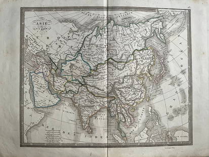
20241839 Asia Map by MoninTitle: 1839 Asia Map by Monin Date/Period: 1839 Materials: Hand colored, engraved Size: 17 1/2 x 12 1/2" This map is an interesting depiction of Asia in 1839 when the continent was still largely unexpSee Sold Price
Sold20241839 Italy Map by MoninTitle: 1839 Italy Map by Monin Date/Period: 1839 Materials: Hand colored, engraved Size: 17 1/2” x 12 1/2” 1839. By V. Monin. Paris. Hand-colored, engraved. Good condition, with some foxinSee Sold Price
Sold2017Sweden & Norway MapSweden & Norway Map. Adam and Charles Black, 1854, 13 x 18 inches No Reserve: This lot starts at $1 and has no reserve as a courtesy so that collectors can determine the true market value on this authSee Sold Price
Sold20231839 Russia Map by MoninTitle: 1839 Russia Map by Monin Date/Period: 1839 Materials: Hand colored, engraved Size: 17 1/2” x 12 1/2” 1839. By V. Monin. Paris. Hand-colored, engraved. Good condition, with some foxiSee Sold Price
Sold20241839 Europe Map by MoninTitle: 1839 Europe Map by Monin Date/Period: 1839 Materials: Hand colored, engraved Size: 17 1/2” x 12 1/2” 1839. By V. Monin. Paris. Hand-colored, engraved. Good condition, with some foxiSee Sold Price
Sold2022Barclay, James C1800 Map. Sweden & NorwayCopper Engraved Map Published C1800 Halifax & Newcastle, England for "Barclay's Universal English Dictionary…" by James Barclay. Maps Engraved by Clerk, Milton and others. Paper Size: 10 x 8 inch (2See Sold Price
Sold2021Guthrie, William 1799 Map Sweden Norway Finland DenmarkOutline Hand Colored Copper Engraved Map Published 1799, London for "A New Geographical, Historical and Commercial Grammar..." by William Guthrie. The maps are by D. Ogilby & Son and others. Folds asSee Sold Price
Sold202320th C. Map of Norway and SwedenSweden and Norway, 20th century color lithograph map, framed and matted under plexiglass. Geo. F. Cran, engraver / publisher. Provenance: Phyllis Lucas Gallery, NYC. [Art: 12.5" H x 9.5" W; Frame: 19"See Sold Price
Sold2021Tallis, John (Pub) 1852 Map. Sweden & NorwaySteel Engraved Map with Original Outline Hand Color Published 1852-56 by John Tallis, London for "The Universal Pronouncing Dictionary" by Thomas Wright. Drawn & Engraved by John Rapkin. Centre fold aSee Sold Price
Sold2022A Scandinavian Stamp collectionA Scandinavian Stamp collection: mostly 20th century mint collection in a Scott album including: Denmark, Finland, Iceland, Norway, Sweden etc, also additional envelopes of loose stamps. Fine to verySee Sold Price
Sold2018Europe.- DuVal (Pierre) L'Europe, one sheet only (ofEurope.- DuVal (Pierre) L'Europe, one sheet only (of four) showing the British Isles, Iceland, Norway, Sweden, Denmark, Netherlands, part of Germany, Belgium, and France, with large floral title cartoSee Sold Price
Sold2016SILVER. Swedish Silver, Ruby, and Sapphire Case.Early 20th century Swedish silver box depicting a map of Norway and Sweden - ruby markers on Fefor, Oslo, and Bastad. Sapphire cabochon closure. Stamped on interior with a maker's mark of WAB, the SweSee Sold Price
Jun 07Freeman's | HindmanMURCHISON, Roderick Impey, Sir. The Silurian System. 1839. COMPLETE WITH VERY RARE HAND-COLORED$1,500
402 Lots AwayMynt AuctionsModern Georgian by Allan Adler Sterling Silver Flatware Set 12 Service 86 pieces$10(1 bid)
3 days LeftMynt AuctionsSwedish Modern by Allan Adler Sterling Silver Cheese Scoop Original 6 1/2"$10
4 days LeftMynt AuctionsSwedish Modern by Allan Adler Sterling Silver Pie Server FH AS Lightly Hammered$10
7 days LeftJasper52NIGERIA w/ early explorers' routes. Lake Chad Yariba Houssa Borgou.SDUK 1844 map$60
Jun 09Worthington GalleriesAntique H/C Map EUROPE SOUS CHARLEMAGNE EN 814: EMPIRES D'OCCIDENT ET D'ORIENT$25