Sold20151812 Hand Colored Map Holy landHandcolored map of the “Tribe of Manasseh” in the Holy land , printed by Mathews and Leigh, 1812. Measures 11 x 9”.See Sold Price
Sold20151812 Handcolored Map of Holy LandHand colored map of the “Tribe of Gad” in the Holy land , printed by Mathews and Leigh, 1812. Measures 11 x 9”.See Sold Price
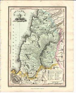
Sold20151812 Hand Colored Map of Holy landHand colored map of the “Tribe of Asher” in the Holy land , printed by Mathews and Leigh, 1812. Measures 9 x 11”.See Sold Price
Sold20161812 Handcolored Map Tribe of Manasseh Holy Land1812 Hand Colored Map of the Holy Land “The Tribe of Manasseh beyond Jordan”. Printed for Mathews and Leigh, measures 9 x 11.5”. Free shipping within the continental USSee Sold Price
Sold20171864 hand-colored map of Palestine by S. AugustusA beautiful example of S. A. Mitchell Jr.'s 1864 map of Palestine, Israel or the Holy Land. Updated from the 1860 variant with new details, an inset of Jerusalem, and a new 1864 copyright. Includes boSee Sold Price
Sold2022Map of the Holy Land, Hand Colored Etching, Paris, 1717.Map of the Holy Land, Hand Colored Etching, Paris, 1717. Title: Terre des fils de Chanaan dont ils s'emparerent sur les descendants de Sem Cartograph: Moullart Sanson. Engraver: Delahaye. Plate: 35.5xSee Sold Price
Sold2024Marmocchi, F. C. 1845 Hand Col Map. Holy Land. Canaan. Israel PalestineFolio Hand Colored Etching/Engraving Published 1845, Florence for "Atlante di Geografia-Storica Universale" by Francesco C. Marmocchi. Paper Size: 17 x 11 inch (43 x 28cm) Good ConditionSee Sold Price
Sold2024Marmocchi, F. C. 1845 Hand Col Map. Holy Land. Persia Empire, Alexander the GreatFolio Hand Colored Etching/Engraving Published 1845, Florence for "Atlante di Geografia-Storica Universale" by Francesco C. Marmocchi. Paper Size: 17 x 11 inch (43 x 28cm) Good ConditionSee Sold Price
Sold2024Marmocchi, F. C. 1845 Hand Col Map. Holy Land. Israel, Jerusalem insetFolio Hand Colored Etching/Engraving Published 1845, Florence for "Atlante di Geografia-Storica Universale" by Francesco C. Marmocchi. Paper Size: 17 x 11 inch (43 x 28cm) Good ConditionSee Sold Price
2018Seutter: Antique Map of Holy Land, 1740Title/Content of Map: Holy Land by Sutter Date Printed: c1740 Cartographer: Matthaus Seutter Material/Medium: Paper Size: 24" x 19 1/2" Original hand colored Copperplate engraved. Published in AugsburSee Sold Price
Sold2016Map of Holy Lands. 1854.Print of hand colored steel engraving .Drawn by L. Dussieux. Engraved by unknown.From „Atlas General De Geographie physique, politique et historique par L. Dussieux. Atlas de Geographie ancienne, duSee Sold Price
2018Mitchell: Antique Map of Palestine, 18641864 hand-colored map of Palestine by S. Augustus Mitchell. A beautiful example of S. A. Mitchell Jr.'s 1864 map of Palestine, Israel or the Holy Land. Updated from the 1860 variant with new details,See Sold Price
Sold2021Sebastian Munster (German, 1488-1552) - Holy Land andSebastian Munster (German, 1488-1552) - Holy Land and Cyprus Map, Woodcut, Circa 1550. Hand colored woodcut. Printed in Basle by Petri. Sheet: 31.5x19.5cm. Plate: 26.5x16.5cm.See Sold Price
Sold2016c. 1670 Engraved Holy Land + Mediterranean MapHistoric Maps c. 1670 Engraved Map of the Holy Land & Mediterranean Sea c. 1670, Historic Hand-Colored Engraved Map entitled: “Terra Sancta sive Promissionis olim Palestina recens delineata,” by FSee Sold Price
Sold2017Stackhouse: Antique Map of Judaea / Holy Land, 1783Map: Judaea or the Holy Land Date Printed: 1783 Cartographer: Thomas Stackhouse Material/Medium: Paper Size: 16" x 20" Condition: Excellent Hand colored. Coperplate engraved. Published in London, PublSee Sold Price
Sold2023Antique German Map of the Holy LandGerman, circa 1730, hand-colored engraving on paper depicting the path of the Children of Israel after their escape from Egypt, 16 1/2" x 20 1/2" sheet size, 21" x 24 1/2" mat size.See Sold Price
Sold2015Map of the Holy Land. Israel. 1835.Print of hand colored steel engraving titled „Carte de la Terre Sainte.Author C. V. Monin.Engraved by unknown.From the „Atlas Universel de Geography by C. V. Monin. Parsi. 1835.The Holy Land as aSee Sold Price
Sold2020Promised Land Map LotLot of two maps of the Holy Land: 1. "A map of the Land of Promise Compiled by the Author out of the Book of Joshua". Hand-colored copperplate engraving. From: Calmet, Augustin Antoine. A historical,See Sold Price
Sold2022Ancient Holy Land with 4 regions divide. 1794 by Vaugondy/ DelamarcheTitle: Ancient Holy Land with 4 regions divide. 1794 by Vaugondy/ Delamarche Date/Period: 1794 Materials: Hand colored copper plate engraved. Size: 16 x 11 1/2" Map shows the holy land from both sidesSee Sold Price
Sold20231874 map of Palestine from S. A. Mitchell, Jr.Very clean and sharp map of Palestine from S. A. Mitchell Jr’s 1874 New General Atlas. A New Map of Palestine of the Holy Land. Beautifully hand-colored at the time of publishing. Has an insetSee Sold Price
Sold2022Biblical themed middle East, Holy land and JerusalemTitle: Biblical themed middle East, Holy land and Jerusalem 1780 by J. de la Porte, Paris Date/Period: 1780 Materials: Hand colored copper plate engraved Size: 9x7'' The main portion of the map is devSee Sold Price
Sold2017Map, holy land, Palestine, by Abraham Ortelius, 1612Early map, Palestine, holy land, by Abraham Ortelius, published in Antwerp, 1612, 14.5" by 18.5"See Sold Price
Sold2022MAP, Holy Land, JanssonHoly Land. Jan Jansson, Tabula Itineraria Patriarcharum Abrahami, Isaaci et Iacobi, from Accuratissima Orbis Antiqui Delineatio…, 1657 (published). Hand Color. A fine decorative map illustrating theSee Sold Price
Sold2019MAP - Holy Land. Mercator/HondiusHoly Land. Mercator/Hondius, Peregrinatio Israelitaru in Deserto, 1610 (published). Hand Color. A handsome small map depicting the Exodus and the wandering of the Children of Israel. An inset of the ESee Sold Price
Jun 08Simpson Galleries, LLC.MATTHAUS SEUTTER (1678-1757) A MAP OF THE HOLY LAND AND TWELVE TRIBES, "Terra Sancta Vocatta Que$150
17 hrs LeftThe Bidder AuctionsJohann Baptista Homann. Terra Sancta Holy Land Map with the Borders of the 12 Tribes of Israel, Hand$100
Jun 23Schilb Antiquarian Rare Books1790 Life of Jesus Christ Fleetwood Bible ART Miracles Jerusalem MAP Holy Land$42(2 bids)
7 days LeftJasper521814 Aaron Arrowsmith map. Israelites from Egypt to Canaan through the desert of Arabia Petraea$140
Jun 04Jasper521875, Brooklyn Bridge under Construction, Prospect Part, sites in the Holy Land. By Hardesty$20
5 days LeftSchilb Antiquarian Rare Books1871 Holy BIBLE & MAPS Holy Land Hitchcock Analysis Gruden Concordance Theology$120(3 bids)
Jun 07Freeman's | Hindman[MAP]. ORTELIUS, Abraham. Presbiteri Iohannis, sive, Abissinorum Imperii Descriptio. 1592.$200
BonhamsSPILSBURY (FRANCIS B.) Picturesque Scenery in the Holy Land and Syria, FIRST EDITION, Edward Orm...£600
4 days LeftTrillium Antique Prints & Rare BooksDavid Roberts - Grand Portico of the Temple of Philae, Nubia$200
BonhamsBLAEU (WILLEM AND JAN) Toonneel des Aerdrycz, oft Nieuwe Atlas... Tweede Deels, 2 parts in 1 vol...£8,000
Jun 04Jasper521803 Poirson Map of Europe -- L'Europe divisee en ses Principaux Etats et d'apres le Traite de Paix$95


![[MAP]. ORTELIUS, Abraham. Presbiteri Iohannis, sive, Abissinorum Imperii Descriptio. 1592. (1 of 2)](https://p1.liveauctioneers.com/197/329395/177650536_1_x.jpg?height=282&quality=70&version=1715364962)


