Sold20241755-1757 Colonial era Chesapeake Bay Region. Virginia and Maryland by BellinTitle: 1755-1757 Colonial era Chesapeake Bay Region. Virginia and Maryland by Bellin Date/Period: 1755-1757 Materials: Copperplate engraved Size: 11 1/2 x 7 1/2” Early settlements, wagon trails,See Sold Price
Sold20241755-1757 Colonial era Louisiana Territory during the French and Indian War by BellinTitle: 1755-1757 Colonial era Louisiana Territory during the French and Indian War by BellinDate/Period: 1755-1757Materials: Hand-colored copperplate engravingSize: 12 x 9”The Mississippi RiverSee Sold Price
Sold20201757 Bellin Map of Colonial Virginia and Maryland --Title/Content of Map: 1757 Bellin Map of Colonial Virginia and Maryland -- Carte de la Baye de Chesapeack et Pays Voisins Cartographer: J Bellin Year/Place: 1758 c., Paris Size: 7.5 X 11.4 in. This isSee Sold Price
Sold2023John Speed 1676 Map of Virginia, Maryland, and Chesapeake BayA MAP OF VIRGINIA AND MARYLAND by John Speed, 1676, engraved by Francis Lamb. London: Thomas Basset and Richard Chiswell. Hand colored. In addition to showing parts of Virginia and Maryland, the map aSee Sold Price
Sold2022Rare Seat of War 1862 Civil War pocket mapVery desirable and scarce large map of the Civil War issued during the early part of the war. Includes Virginia, Maryland and the Chesapeake Bay along with parts of other states. Depicts the entire EaSee Sold Price
Sold2024Henricus Hondius 1630 "Nova Virginiae Tabula" Hand Colored Map of Virginia and Chesapeake #1Antique, original hand-colored map of Virginia and the Chesapeake Bay originally by Henricus Hondius in 1630 titled "Nova Virginiae Tabula". With French text on reverse final catchword "n'en" and signSee Sold Price
Sold20151731 Arrest Warrant Never Paid For His SlaveBlack History 1731 Arrest Warrant: Received His Slave & Failed to Pay March 23, 1731-Dated Early Colonial Era, Partially-Printed Document Signed, Boston, Massachusetts-Bay, Choice Very Fine. This 1731See Sold Price
Sold2023Van Keulen map of the Chesapeake Bay AreaVAN KEULEN, Johannes (1654-1715). Pas Kaart van de Zee Kuysten van Virginia. Engraved map with original hand color in part. Amsterdam, circa 1695. 20 3/4” x 24” sheet, 25” x 28 1/2&rSee Sold Price
Sold2022Black duck, Sebastian Taylor, Eastern shore of Virginia, 1st quarter 20th century.Black duck, Sebastian Taylor, Eastern shore of Virginia, 1st quarter 20th century. Scratch feather paint detail and slightly raised head. Measures 16" long. Literature: "Chesapeake Bay Decoys," RobertSee Sold Price
Sold202117th C. Map of Virginia: Nova Virginia TabulaImportant hand colored early map, the second state of the first published map made after John Smith's map of the area around the Chesapeake Bay. Notable in part for its vignettes showing Native AmericSee Sold Price
Sold2022Antique 1719 English Map of the Chesapeake Bay by John SenexAntique early English map of the Chesapeake Bay, showing the principal settlements of this tobacco and cotton producing region. Engraved in London in 1719 by John Senex map is titled The Sea of VirginSee Sold Price
Sold2020MORTIER, PIERRE. Carte Particuliere de Virginie,MORTIER, PIERRE. Carte Particuliere de Virginie, Maryland, Pennsilvanie, la Nouvelle Jarsey Orient et Occidentale. Large double-page engraved chart of the Chesapeake Bay. 25x37 inches sheet size, wideSee Sold Price
Sold202417th C. Land Documents17th C. Land Documents, includes: 1682 Survey of land at Chesapeake Bay for Samuel Jackson; Charles II 1684 land grant to Charles Hopkins (on parchment) Somerset County Maryland; and a 1734 IndentureSee Sold Price
Sold2017Fry & Jefferson. Maryland and Virginia mapdated 1755; "Carte de la Virginie et de Maryland," (sic) by Robert de Vaugondy based on a map by Joshua Fry and Peter Jefferson, 21 x 26 in., in ebonized giltwood eglomise frameSee Sold Price
Sold2024Exceptional 18th Century Map of The Carolinas, Maryland and VirginiaBy Johann Baptist Homann, Germany, late 17th/early 18th century. Hand colored map of the region which is excellent and quite rare. The map giving excellent details of the region and having exquisite eSee Sold Price
Sold2023[MAP]. FRY & JEFFERSON. A Map of the Most Inhabited Part of Virginia. 1775. FIRST PRINTED MAP OF[MAPS & ATLASES]. FRY, Joshua (1699-1754) and Peter JEFFERSON (1708-1757). A Map of the Most Inhabited Part of Virginia containing the whole Province of Maryland with Part of Pensilvania, New JersSee Sold Price
Sold2022Rare oversize black duck, Leonard Pryor, Chesapeake City, Maryland, 1st quarter 20th century.Rare oversize black duck, Leonard Pryor, Chesapeake City, Maryland, 1st quarter 20th century. Measures 17" long x 7.5" wide. Two piece body. Literature: "Decoys of the Mid Atlantic Region," Henry FlecSee Sold Price
Sold2022RARE NATIVE AMERICAN / FRONTIERSMAN COLONIAL-ERA PIPE TOMAHAWKRARE NATIVE AMERICAN / FRONTIERSMAN COLONIAL-ERA PIPE TOMAHAWK, triangular blade, iron with steel blade edge, oval eye flanked by two vertical ridges to each side, octagonal bowl-form pipe poll on octSee Sold Price
Sold20241719 Map of Colonial era North America, by Sanson - JaillotTitle: 1719 Map of Colonial era North America, by Sanson - Jaillot Date/Period: 1719 Materials: Copperplate engraved Size: 25 1/2 x 18” This map is a rare and valuable map of history, showing NoSee Sold Price
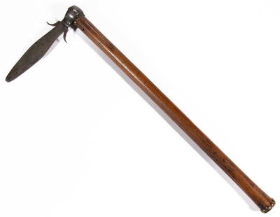
Sold2022FINE COLONIAL-ERA NATIVE AMERICAN SPONTOON TOMAHAWKFINE COLONIAL-ERA NATIVE AMERICAN SPONTOON TOMAHAWK, French-style blade of thin tapered form with punched dots along the lower edges and two up-curled side flanges, likely original hickory haft with bSee Sold Price
Sold2021Spanish Colonial Era Hallway BenchSpanish Colonial Era hallway bench, circa 19th century, carved wooden frame with pie crust trim 36 x 96 x 20" Provenance: The Collection of Chris Hill (San Antonio, TX) We happily provide seamlessSee Sold Price
Sold2021Important Spanish Colonial Era SideboardImportant Spanish Colonial Era sideboard, having heavily carved and ornately painted religious motif with Archangel Gabriel, with two open shelves, circa 1890 41"h x 51.5"w x 21"d Provenance: An AusSee Sold Price
Sold20201765 Volume with 50 Colonial Maryland NEGRO LawsColonial America 1765 Custom Bound Volume "Laws of Maryland At Large, With Proper Indexes" with 50 Maryland Laws Re: "Negroes" (1637 to 1763) 1765-Dated Large Bound Volume titled, "Laws of Maryland AtSee Sold Price
Sold2023Spanish Colonial Era Mirror18th century.The rectangular plate within a lappet frame carved with gilt winged Seraphim beneath a gilt starburst crest.34in (86cm)h. 25in. (63cm) w.See Sold Price
1 day LeftJasper52Bellin Map of St. Salvador, Brazil -- Plan de la ville de St. Salvador [with] Vue de la Ville de St.$55


![[MAP]. FRY & JEFFERSON. A Map of the Most Inhabited Part of Virginia. 1775. FIRST PRINTED MAP OF: [MAPS & ATLASES]. FRY, Joshua (1699-1754) and Peter JEFFERSON (1708-1757). A Map of the Most Inhabited Part of Virginia containing the whole Province of Maryland with Part of Pensilvania, New Jers](https://p1.liveauctioneers.com/197/305583/163286504_1_x.jpg?height=310&quality=70&version=1697143109)


![Bellin Map of St. Salvador, Brazil -- Plan de la ville de St. Salvador [with] Vue de la Ville de St. (1 of 1)](https://p1.liveauctioneers.com/5584/328338/176911634_1_x.jpg?height=282&quality=70&version=1715113718)


