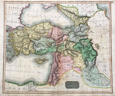
17th c. Antique H/C Map of Ottoman / Turkish Empire
Similar Sale History
View More Items in Maps & AtlasesRelated Maps & Atlases
More Items in Maps & Atlases
View MoreRecommended Transportation & Travel Collectibles
View More


Item Details
Description
Map - Accuratissima et maxima totius Turcici Imperii tabula cum omnibus suis regionibus novissima delineatio | Title: Accuratissima et maxima totius Turcici Imperii tabula cum omnibus suis regionibus novissima delineatio Title (alt.): Collection of old maps Creator: Danckerts, Justus, 1635-1701 Name on Item: per I. Danckerum. Date: [ca. 1680] | | | A map of Turkish possessions including Egypt and Greece by Justus Danckerts (1635-1701), and showing the Arabian peninsula in the center. A decorative cartouche adorned with several costumed figures, a pyramid, and lions. Amsterdam. Approx. Image: 19 ½ x 23 ¼ | Date 1688 Source 29. Accuratissine et Maxima Totius Turcici Imperii Tabula cum Omnibus suis Regionibus Novissima Delineatio // Mitchell King atlas (1662-1695)
Dimensions
19.5 x 23.25 in
Buyer's Premium
- 25% up to $999.00
- 25% above $999.00
17th c. Antique H/C Map of Ottoman / Turkish Empire
Estimate $500 - $1,000
6 bidders are watching this item.
Shipping & Pickup Options
Item located in Gallatin (Nashville), TN, usOffers In-House Shipping
Local Pickup Available
Payment
Accepts seamless payments through LiveAuctioneers

TOP


![Ortelius City View of Daphne in Anticoch (Suburb of: [Asia] ORTELIUS, Abraham (1527-1598). Daphne, Antiochiae Suburbium [Besiktas in Instanbul, Turkey]. Engraving. Antwerp, c. 1590. 18 5/8" x 22 1/2" sheet. Unusual Artistic View of the Paradise of Daphn](https://p1.liveauctioneers.com/1968/216191/110783516_1_x.jpg?height=310&quality=70&version=1629990486)


![Battle of Coronel, November 1st 1914. First World War. 1920 old antique map: CAPTION PRINTED BELOW PICTURE: Coronel November 1st 1914 [Battle of Coronel] DATE PRINTED: 1920 IMAGE SIZE: Approx 68.0 x 55.5cm, 26.75 x 21.75 inches (Large); Please note that this is a folding map.](https://p1.liveauctioneers.com/5584/326888/175994716_1_x.jpg?height=310&quality=70&version=1713903186)


