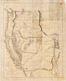
Antique 1846 Mitchel's Wall Map of American Republic
Similar Sale History
View More Items in Maps & AtlasesRelated Maps & Atlases
More Items in Maps & Atlases
View MoreRecommended Transportation & Travel Collectibles
View More


Item Details
Description
Antique 1846 Mitchell national map of American Republic. This map was published by Samuel Augustus Mitchell in 1846 in Philadelphia. Mitchell started his working life as a teacher, but was inspired to go into map making and educational publishing after learning the poor quality of geographical resources for teachers.
The dimensions are 54in x 41in x 1.5in. It is in good condition for its age with discoloration, stains, and frayed and worn edges. Please call or email for a detailed condition report.
The dimensions are 54in x 41in x 1.5in. It is in good condition for its age with discoloration, stains, and frayed and worn edges. Please call or email for a detailed condition report.
Condition
See description and photos for condition. Please email or call for a more detailed condition report. We grade on a scale from excellent, very good, good, fair, to poor; that said, all lots are sold in as is condition at time of sale, and condition listings are given as a courtesy for guidance only and should be evaluated by personal inspection by the bidder.
Dimensions
54 x 41 x 1.5 in
Buyer's Premium
- 20%
Antique 1846 Mitchel's Wall Map of American Republic
Estimate $400 - $600
16 bidders are watching this item.
Shipping & Pickup Options
Item located in Hudson, NY, usSee Policy for Shipping
Local Pickup Available
Payment
Accepts seamless payments through LiveAuctioneers

TOP


![North-west Europe. Nordic Countries. British Isles Scandinavia. THOMSON 1830 map: TITLE/CONTENT OF MAP: [Europe after the Congress of Vienna - North-west sheet] DATE PRINTED: 1830 IMAGE SIZE: Approx 53.0 x 65.0cm, 20.75 x 25.5 inches (Large); Please note that this is a folding map.](https://p1.liveauctioneers.com/5584/328641/177014337_1_x.jpg?height=310&quality=70&version=1715113718)
![North-west Europe. Nordic Countries. British Isles Scandinavia. THOMSON 1817 map: CAPTION PRINTED BELOW PICTURE: [Europe after the Congress of Vienna - North-west sheet] DATE PRINTED: Published in 1817. Engraved in 1816; this date is marked on the map IMAGE SIZE: Approx 53.0 x 63.0](https://p1.liveauctioneers.com/5584/328641/177014463_1_x.jpg?height=310&quality=70&version=1715113718)


![[Maps] Gio. Ant. Magnini, Italia, 1620: [Maps] Gio. Ant. Magnini, Italia, 1620, Giovanni Antonio Magnini. Italia, data in luce da Fabio suo figliuolo al Serenissimo Ferdinado Gonzaga Duca di Matoua edi Monserrato etc. Bologna, for Sebastian](https://p1.liveauctioneers.com/188/326797/176317457_1_x.jpg?height=310&quality=70&version=1713847031)
![[Maps] Martin Zeiler, Itinerarium Italiae, 1640: [Maps] Martin Zeiler, Itinerarium Italiae, 1640, Martini Zeilleri. Itinerarium Italiae Nov-Antiquae: oder, Raiss-Beschreibung durch Italien, Matthaus Merian, Frankfurt, 40 plates, most double-page, in](https://p1.liveauctioneers.com/188/326797/176317459_1_x.jpg?height=310&quality=70&version=1713847031)


