


Color maps of Canada, 1880
Similar Sale History
View More Items in Maps & Atlases


Related Maps & Atlases


![d'Anville (Jean Baptiste Bourguignon) [Untitled Composite Atlas with 102 map sheets], [probably: d'Anville (Jean Baptiste Bourguignon) [Untitled Composite Atlas with 102 map sheets], comprising 20 double-page maps, 9 two-sheet double-page maps, 3 two-sheet maps on folding double-pages [Asia, Afri](https://p1.liveauctioneers.com/5458/329231/177514974_1_x.jpg?height=310&quality=70&version=1715269091)
![1894 Johnston Map of Oceania [verso] Island in the Indian Ocean and Near Africa -- Oceania [verso]: Title: 1894 Johnston Map of Oceania [verso] Island in the Indian Ocean and Near Africa -- Oceania [verso] Madagascar; Mauritius; Seychelles; Cape Town; St. Helena and Ascension Islands; Socotra; Aden](https://p1.liveauctioneers.com/5584/328338/176911535_1_x.jpg?height=310&quality=70&version=1715113718)
More Items in Maps & Atlases
View More


![[Maps] Gio. Ant. Magnini, Italia, 1620: [Maps] Gio. Ant. Magnini, Italia, 1620, Giovanni Antonio Magnini. Italia, data in luce da Fabio suo figliuolo al Serenissimo Ferdinado Gonzaga Duca di Matoua edi Monserrato etc. Bologna, for Sebastian](https://p1.liveauctioneers.com/188/326797/176317457_1_x.jpg?height=310&quality=70&version=1713847031)
![[Maps] Martin Zeiler, Itinerarium Italiae, 1640: [Maps] Martin Zeiler, Itinerarium Italiae, 1640, Martini Zeilleri. Itinerarium Italiae Nov-Antiquae: oder, Raiss-Beschreibung durch Italien, Matthaus Merian, Frankfurt, 40 plates, most double-page, in](https://p1.liveauctioneers.com/188/326797/176317459_1_x.jpg?height=310&quality=70&version=1713847031)


Recommended Transportation & Travel Collectibles
View More


Item Details
Description
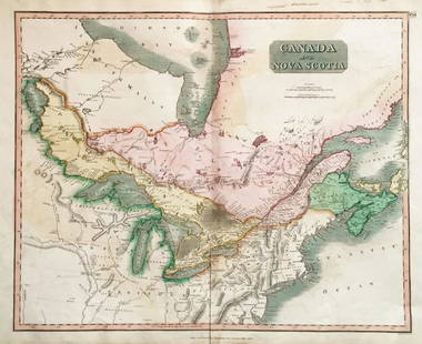
Heading: (Canada)
Author: Hurlbert, J. Beaufort
Title: Physical Atlas with Coloured Maps, showing...the Dominion of Canada
Place Published: [Ottawa]
Publisher:
Date Published: [1880]
Description:
Author: Hurlbert, J. Beaufort
Title: Physical Atlas with Coloured Maps, showing...the Dominion of Canada
Place Published: [Ottawa]
Publisher:
Date Published: [1880]
Description:
36 pp. Illustrated with 10 color folding maps. 34x25.5 cm. (13½x10"), brown cloth stamped in gilt.
Atlas of Canada including "the geographical distribution of plants yielding food, climates, flora, soils, regions of summer rains, geological formations and hydrography."
Condition
Spine nearly perished, some wear to covers; hinges cracked; offsetting to endpapers, previous owner's signature on front pastedown, toning to pages, some tears to maps; overall good.
Buyer's Premium
- 25%
Color maps of Canada, 1880
Estimate $200 - $300
2 bidders are watching this item.
Shipping & Pickup Options
Item located in Berkeley, CA, usOffers In-House Shipping
Local Pickup Available
Payment

Related Searches
TOP