


1860 Mitchell Map of Florida, South and North Carolina
Similar Sale History
View More Items in Maps & Atlases


![Mitchell: Antique Map of Florida & South Carolina, 1860: Map: 1860 Mitchell Map of Florida and South Carolina -- County Map of Florida [on sheet with] County Map of South Carolina Date Printed: 1860, Philadelphia Cartographer: S Mitchell Size: 9.1 x 10.6 in](https://p1.liveauctioneers.com/5584/109294/56069180_1_x.jpg?height=310&quality=70&version=1505338533)
![1860 Mitchell Map of Florida and South Carolina --: Title/Content of Map: 1860 Mitchell Map of Florida and South Carolina -- County Map Of Florida [on sheet with] Map Of South Carolina Date: 1860, PhiladelphiaCartographer: S Mitchell Size: 10.8 x 13.2](https://p1.liveauctioneers.com/5584/144953/73284299_1_x.jpg?height=310&quality=70&version=1562102885)


![(4) 1838 BRADFORD Maps: NC, SC, GA, FL.: [United States/South] 4 Maps. ++ NORTH CAROLINA. ++ SOUTH CAROLINA. ++ GEORGIA. ++ FLORIDA. ++ +Maps 28, 30, 31, 32 from T. G. Bradford, “An Illustrated Atlas, Geographical, Statistical, And Histori](https://p1.liveauctioneers.com/179/85723/44107998_1_x.jpg?height=310&quality=70&version=1457209205)
Related Maps & Atlases


![Large Map of Kentucky and Tennessee: Large Map of Kentucky and Tennessee With map of North Dakota and South Dakota [separately] on versos Cartographer: George Franklin Cram Dated: Circa 1900 Type: Color Lithograph](https://p1.liveauctioneers.com/5614/330257/178045311_1_x.jpg?height=310&quality=70&version=1716032806)


More Items in Maps & Atlases
View More


![[MAP]. TODESCHI, Pietro. [Nova et Acurata Totius Americae Tabula auct. G.I. Blaeu] America quarta: [MAP]. TODESCHI, Pietro. [Nova et Acurata Totius Americae Tabula auct. G.I. Blaeu] America quarta pars orbis quam plerunq, nuvum orbem appellitant primo detecta est anno 1492 a Christophoro Columbo...](https://p1.liveauctioneers.com/197/329395/177650542_1_x.jpg?height=310&quality=70&version=1715364962)


![[MAPS]. HOMANN, Johann Baptist, HOMANN HEIRS, and Georg Matthäus SEUTTER. [Composite Atlas].: [MAPS]. HOMANN, Johann Baptist (1663-1724), HOMANN HEIRS, and Georg Matthäus SEUTTER (1678-1757). [Composite Atlas]. [Nuremberg, Augsburg, and others: Homann Heirs and others, maps dated between](https://p1.liveauctioneers.com/197/329395/177650530_1_x.jpg?height=310&quality=70&version=1715364962)


![[MAP]. ORTELIUS, Abraham. Turcici Imperii Descriptio.1592.: [MAP]. ORTELIUS, Abraham (1527-1598). Turcici Imperii Descriptio. Antwerp, 1592. Engraved map with hand-coloring. Matted, framed, and double glazed, sight 406 x 521 mm (unexamined out of frame). Decor](https://p1.liveauctioneers.com/197/329395/177650538_1_x.jpg?height=310&quality=70&version=1715364962)
Recommended Transportation & Travel Collectibles
View More


Item Details
Description
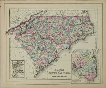
A handsome and unusual county map of three southern states, orienting South and North Carolina 90 degrees from Florida to allow fitting all three onto one page. Much of South Florida is undeveloped. This richly detailed map shows railroad lines of the day as well. Inset is Charleston Harbor.
Reserve: $70.00
Shipping:
Your purchase is protected:
Photos, descriptions, and estimates were prepared with the utmost care by a fully certified expert and appraiser. All items in this sale are guaranteed authentic.
In the rare event that the item did not conform to the lot description in the sale, Jasper52 specialists are here to help. Buyers may return the item for a full refund provided you notify Jasper52 within 5 days of receiving the item.
Condition
Very Good. Slight age toning, primarily in the margins. Colored.
Buyer's Premium
- 15%
1860 Mitchell Map of Florida, South and North Carolina
Estimate $80 - $100
3 bidders are watching this item.
Shipping & Pickup Options
Item located in Ohio, US$14 shipping in the US
Payment
Accepts seamless payments through LiveAuctioneers
See More Items From This Jasper52 Seller

Related Searches
TOP