


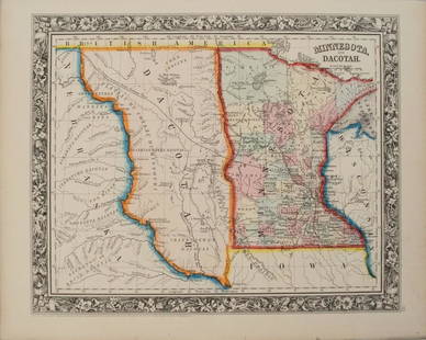
1876 Mitchell Map of Colorado, Wyoming, Dakotas,
Similar Sale History
View More Items in Maps & Atlases


![1869 Mitchell Map of Plains States and Colorado --: Title/Content of Map: 1869 Mitchell Map of Plains States and Colorado -- XVIII Kansas, Colorado, New Mexico and Indian Territory [verso] XVI Minnesota and Dakota [also] XVII Nebraska Cartographer: S M](https://p1.liveauctioneers.com/5584/179983/90569362_1_x.jpg?height=310&quality=70&version=1601417445)
![Box of Assorted Maps [147388]: Box of approx 120 maps,1960's to 1970's? Folding road maps of the West, Big Bend National Park, Missouri, Texas, Wyoming, Colorado, Yellowstone, S. Dakota, Colorado Parks and more.](https://p1.liveauctioneers.com/2699/299063/159201775_1_x.jpg?height=310&quality=70&version=1692045182)


![1895 Cram Map of Colorado [verso] North Dakota --: Title: 1895 Cram Map of Colorado [verso] North Dakota -- Colorado [verso] North Dakota Date: 1895, Chicago Cartographer: G Cram Size: 10.2 X 13 in. Additional Information: This is a very nice and deta](https://p1.liveauctioneers.com/5584/159675/80583710_1_x.jpg?height=310&quality=70&version=1579644740)


Related Maps & Atlases


![1869 Mitchell Map of South-Central Europe [verso] Asia -- XXXIV Austria, Switzerland, Italy, Turkey: Title: 1869 Mitchell Map of South-Central Europe [verso] Asia -- XXXIV Austria, Switzerland, Italy, Turkey and Greece [verso] XXXVI Asia Cartographer: S Mithchell Year / Place: 1869, Philadelphia Map](https://p1.liveauctioneers.com/5584/328338/176911683_1_x.jpg?height=310&quality=70&version=1715113718)


![1869 Mitchell Map of Much of Western Europe -- XXXII Prussia the German States Holland & Belgium: Title: 1869 Mitchell Map of Much of Western Europe -- XXXII Prussia the German States Holland & Belgium [verso] XXXIII France, Spain, Portugal and Belgium Cartographer: S Mithchell Year / Place: 1869,](https://p1.liveauctioneers.com/5584/328338/176911579_1_x.jpg?height=310&quality=70&version=1715113718)
![1858 Mitchell Map of Great Britain and Ireland [verso] Germany and Switzerland -- No. 22 Map of: Title: 1858 Mitchell Map of Great Britain and Ireland [verso] Germany and Switzerland -- No. 22 Map of Great Britain and Ireland [verso] No. 23 Map of Germany Switzerland and Northern Italy Cartograph](https://p1.liveauctioneers.com/5584/328338/176911589_1_x.jpg?height=310&quality=70&version=1715113718)
![1858 Mitchell Map of Southern Europe and France [verso] Asia -- No. 24 Map of France, Spain,: Title: 1858 Mitchell Map of Southern Europe and France [verso] Asia -- No. 24 Map of France, Spain, Portugal & Italy [verso] No. 26 Map of Asia Cartographer: S Mitchell Year / Place: 1858, Philadelphi](https://p1.liveauctioneers.com/5584/328338/176911601_1_x.jpg?height=310&quality=70&version=1715113718)


![1878 Mitchell Map of Virginia and West Virginia [verso] New Jersey, Maryland and Delaware -- County: Title: 1878 Mitchell Map of Virginia and West Virginia [verso] New Jersey, Maryland and Delaware -- County Map ofVirginia and West Virginia [Verso} County Map of Maryland and Delaware [with] County Ma](https://p1.liveauctioneers.com/5584/329422/177662152_1_x.jpg?height=310&quality=70&version=1715717898)

More Items in Maps & Atlases
View More![[Maps] Gio. Ant. Magnini, Italia, 1620: [Maps] Gio. Ant. Magnini, Italia, 1620, Giovanni Antonio Magnini. Italia, data in luce da Fabio suo figliuolo al Serenissimo Ferdinado Gonzaga Duca di Matoua edi Monserrato etc. Bologna, for Sebastian](https://p1.liveauctioneers.com/188/326797/176317457_1_x.jpg?height=310&quality=70&version=1713847031)

![[Maps] Martin Zeiler, Itinerarium Italiae, 1640: [Maps] Martin Zeiler, Itinerarium Italiae, 1640, Martini Zeilleri. Itinerarium Italiae Nov-Antiquae: oder, Raiss-Beschreibung durch Italien, Matthaus Merian, Frankfurt, 40 plates, most double-page, in](https://p1.liveauctioneers.com/188/326797/176317459_1_x.jpg?height=310&quality=70&version=1713847031)


![[MAP]. TODESCHI, Pietro. [Nova et Acurata Totius Americae Tabula auct. G.I. Blaeu] America quarta: [MAP]. TODESCHI, Pietro. [Nova et Acurata Totius Americae Tabula auct. G.I. Blaeu] America quarta pars orbis quam plerunq, nuvum orbem appellitant primo detecta est anno 1492 a Christophoro Columbo...](https://p1.liveauctioneers.com/197/329395/177650542_1_x.jpg?height=310&quality=70&version=1715364962)


Recommended Transportation & Travel Collectibles
View More


Item Details
Description
A very nice, large map of the upper Midwest and part of the West, full of detail on settlements, topography, railroads, color-coded counties, etc. The counties are not yet fully formed and the Dakotas have not yet split into two.
Reserve: $100.00
Shipping:
Your purchase is protected:
Photos, descriptions, and estimates were prepared with the utmost care by a fully certified expert and appraiser. All items in this sale are guaranteed authentic.
In the rare event that the item did not conform to the lot description in the sale, Jasper52 specialists are here to help. Buyers may return the item for a full refund provided you notify Jasper52 within 5 days of receiving the item.
Condition
Very good. Slight age toning. Issued centerfold. Colored.
Buyer's Premium
- 15%
1876 Mitchell Map of Colorado, Wyoming, Dakotas,
Estimate $120 - $150
4 bidders are watching this item.
Shipping & Pickup Options
Item located in Ohio, US$14 shipping in the US
Payment
Accepts seamless payments through LiveAuctioneers
See More Items From This Jasper52 Seller

Related Searches
TOP