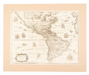
John Senex Map of North and South America 1719-17
John Senex Sale History
View Price Results for John Senex
Related Maps & Atlases
More Items in Maps & Atlases
View MoreRecommended Transportation & Travel Collectibles
View More


Item Details
Description
John Senex (1678–1740), "A New Map of America from the Latest Observations," London, ca. 1719-1721. Hand colored copperplate engraved map of North and South America, from Senex's "New General Atlas," D. Brown, London, 1721. Notable features of this map include the depiction of California as an island and the inclusion of a lake in Northwest North America called "The Great Lake of Thoago or Thoya," along with a fanciful depiction of the northwest coastline and islands of North America.
Cartouche in the upper left corner reads: "A New Map of America From the latest Observations Revis'd by I. Senex. Most humbly Inscribed to the Right Honble. The Earl of Berkshire etc. Deputy Earl Marshal of England." Printed "I. Harris Fecit" in the lower left corner. Dimensions: Height: 19 3/4 in x width: 22 1/4 in.
Cartouche in the upper left corner reads: "A New Map of America From the latest Observations Revis'd by I. Senex. Most humbly Inscribed to the Right Honble. The Earl of Berkshire etc. Deputy Earl Marshal of England." Printed "I. Harris Fecit" in the lower left corner. Dimensions: Height: 19 3/4 in x width: 22 1/4 in.
SKU: 03137
Condition
Good condition, vertical crease, and minor soiling.
Buyer's Premium
- 28%
John Senex Map of North and South America 1719-17
Estimate $1,000 - $1,500
6 bidders are watching this item.
Shipping & Pickup Options
Item located in St. Paul, MN, usSee Policy for Shipping
Payment

TOP


![1761 NEW DICTIONARY OF TRADE & COMMERCE R. ROLT antique FOLIO ILLUSTRATED w/MAPS: A New Dictionary of Trade and Commerce... The Second edition [preface by Samuel Johnson] With the Addition of a New and Accurate Set of Maps... by Mr. Bowen. London: 1761 by Richard ROLT. Folio: 9.5 b](https://p1.liveauctioneers.com/5584/327967/176717236_1_x.jpg?height=310&quality=70&version=1714507672)


![[Maps] Gio. Ant. Magnini, Italia, 1620: [Maps] Gio. Ant. Magnini, Italia, 1620, Giovanni Antonio Magnini. Italia, data in luce da Fabio suo figliuolo al Serenissimo Ferdinado Gonzaga Duca di Matoua edi Monserrato etc. Bologna, for Sebastian](https://p1.liveauctioneers.com/188/326797/176317457_1_x.jpg?height=310&quality=70&version=1713847031)


