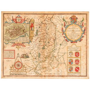
Early English road map by John Ogilby
Similar Sale History
View More Items in Maps & AtlasesRelated Maps & Atlases
More Items in Maps & Atlases
View MoreRecommended Transportation & Travel Collectibles
View More


Item Details
Description
Heading: (Maps)
Author: Ogilby, John
Title: The Road from London to St. Neotts in Com. Hunt. Continued to Oakeham in Com Rutland
Place Published: London
Publisher:
Date Published: 1675
Description:
Author: Ogilby, John
Title: The Road from London to St. Neotts in Com. Hunt. Continued to Oakeham in Com Rutland
Place Published: London
Publisher:
Date Published: 1675
Description:
Copper-engraved map, hand-colored (modern). 34.3x45.8 cm. (13½x18").
Strip map in the form of scrolls, delineating the road from High Barnet to Oakeham.. The road map is in the pictorial style pioneered by Ogilby, depicting the various towns, rivers, mountains and other features along the way. The map begins in High Barnet and proceeds in a northerly direction on the Holy Head Road to Oakeham. The pictorial title cartouche includes a hunter with his dogs in pursuit of a stag.
Condition
A few small edge chips and tears, neat repairs at centerfold; very good or better.
Buyer's Premium
- 25%
Early English road map by John Ogilby
Estimate $10 - $100
2 bidders are watching this item.
Get approved to bid.
Shipping & Pickup Options
Item located in Berkeley, CA, usSee Policy for Shipping
Payment

Related Searches
TOP


![[ANTIQUE MAPS] OGILBY--YORK TO WHITBY, SCARBORO 1675: [ANTIQUE MAPS] OGILBY, John "YORK TO WHITBY, SCARBORO" London, UK 1675. 50X36cm. Scrolled road map. Framed. Hand-coloured. The complete route, with a spur from New Malton to Scarborough. Frame not inc](https://p1.liveauctioneers.com/8321/253807/131946541_1_x.jpg?height=310&quality=70&version=1657215628)


![OGILBY, John (1600-1676). The Road from Cambridg: OGILBY, John (1600-1676). The Road from Cambridg to Coventry. [London, ca 1570s]. Engraved scroll map hand-colored in wash and outline, visible area 17 1/4 x 14 1/14 in. (444 x 360 mm). Deco](https://p1.liveauctioneers.com/197/151909/76680351_1_x.jpg?height=310&quality=70&version=1570472488)


![[Maps] Martin Zeiler, Itinerarium Italiae, 1640: [Maps] Martin Zeiler, Itinerarium Italiae, 1640, Martini Zeilleri. Itinerarium Italiae Nov-Antiquae: oder, Raiss-Beschreibung durch Italien, Matthaus Merian, Frankfurt, 40 plates, most double-page, in](https://p1.liveauctioneers.com/188/326797/176317459_1_x.jpg?height=310&quality=70&version=1713847031)


![[Maps] Gio. Ant. Magnini, Italia, 1620: [Maps] Gio. Ant. Magnini, Italia, 1620, Giovanni Antonio Magnini. Italia, data in luce da Fabio suo figliuolo al Serenissimo Ferdinado Gonzaga Duca di Matoua edi Monserrato etc. Bologna, for Sebastian](https://p1.liveauctioneers.com/188/326797/176317457_1_x.jpg?height=310&quality=70&version=1713847031)


