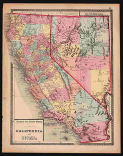
Group of Early Maps of California & the Southwest
Similar Sale History
View More Items in Maps & Atlases![Carte De La Californie Suivant (early Group of 5 California maps) 1772 [171215]: A spectacular set of 5 maps showing California history from 1604 to 1767. Measures 15x12[x=#8221/]. 1) Earliest map (upper right) is based upon a manuscript map by Mathieu Neron Pecci drawn in Florenc](https://p1.liveauctioneers.com/2699/324080/174413209_1_x.jpg?height=310&quality=70&version=1711485545)
Related Maps & Atlases
More Items in Maps & Atlases
View MoreRecommended Transportation & Travel Collectibles
View More


Item Details
Description
(1) Geological Plan of the Coast Range of California from San Francisco Bay to Los Angeles. c.1856. 22 3/4 x 29 1/2 inches
(2) New Rail Road and County Map of Northern California and Nevada.18 3/4 x 26 3/8 inches
(3) New Rail Road and County Map of Southern California and Arizona. 18 3/4 x 26 1/4 inches
(4) Asher & Adams' California & Nevada, South Portion. 1872. 23 1/4 x 29 1/4 inches
(5) Asher & Adams' California & Nevada, North Portion. 1872. 29 1/2 x 23 1/2 inches
(5) California and Nevada, including Plan of Sacramento, The Vicinity of San Francisco, and Map of the Yosemite Valley. California Geological Survey. 33 3/8 x 22 1/2 inches
Condition
Condition summary available on request. The absence of a condition report does not imply that the lot is in perfect condition. Santa Fe Art Auction shall have no responsibility for any error or omission.
Buyer's Premium
- 25% up to $500,001.00
- 20% up to $1,000,001.00
- 17% above $1,000,001.00
Group of Early Maps of California & the Southwest
Estimate $300 - $500
2 bidders are watching this item.
Shipping & Pickup Options
Item located in Santa Fe, NM, usSee Policy for Shipping
Payment

TOP


![[MAPS]. A group of 9 early engraved maps and views, includi...: [MAPS]. A group of 9 early engraved maps and views, including: PORCACCHI, Tomaso. Descrittione Dell’Isola di S. Lorenzo. Venice, circa 1570s–1600s. Engraved and hand colored map vignette,](https://p1.liveauctioneers.com/928/252933/131521916_1_x.jpg?height=310&quality=70&version=1656110480)


![Group of 14 Ireland County Maps: Group of 14 early 20th century Ireland County maps, in partial color, including Cork, Donegal, Kerry, Dublin, Galway, and others. Provenance: Phyllis Lucas Gallery, NYC. [6 1/2" H x 9 3/4" W]. Light t](https://p1.liveauctioneers.com/1221/310017/167287163_1_x.jpg?height=310&quality=70&version=1702345350)


![[NEW YORK CITY – PICTORIAL MAPS]. Group of 3 pictorial maps...: [NEW YORK CITY – PICTORIAL MAPS]. Group of 3 pictorial maps. Including: ANNAND, George (1890—1980). Sinclair Pictorial Map of New York/New York World’s Fair. 26 ¾ x 27 5/8”](https://p1.liveauctioneers.com/928/325952/175495562_1_x.jpg?height=310&quality=70&version=1712935174)
![1795 Pazzini Carli Map of Southwest England -- Le Provincie Che Sono al Sud Ouest Dell' Inghilterra: Title: 1795 Pazzini Carli Map of Southwest England -- Le Provincie Che Sono al Sud Ouest Dell' Inghilterra Cartographer: Pazzini Carli [family] Year / Place: 1795, Siena Map Dimension (in.): 9.1 X 12.](https://p1.liveauctioneers.com/5584/328338/176911548_1_x.jpg?height=310&quality=70&version=1715113718)


![[MAPS]. A group of 3 engraved maps, most with hand-coloring.: [MAPS]. A group of 3 maps, comprising: HOMANN, Johann Baptist (1663-1724). Regni Mexicani seu Novae Hispaniae, Ludovicianae, N. Angliae, Carolinae, Virginiae et Pensylvaniae. Nuremberg: Homann, [ca 17](https://p1.liveauctioneers.com/197/328642/177014805_1_x.jpg?height=310&quality=70&version=1714760103)


![[Maps] Gio. Ant. Magnini, Italia, 1620: [Maps] Gio. Ant. Magnini, Italia, 1620, Giovanni Antonio Magnini. Italia, data in luce da Fabio suo figliuolo al Serenissimo Ferdinado Gonzaga Duca di Matoua edi Monserrato etc. Bologna, for Sebastian](https://p1.liveauctioneers.com/188/326797/176317457_1_x.jpg?height=310&quality=70&version=1713847031)
![[Maps] Martin Zeiler, Itinerarium Italiae, 1640: [Maps] Martin Zeiler, Itinerarium Italiae, 1640, Martini Zeilleri. Itinerarium Italiae Nov-Antiquae: oder, Raiss-Beschreibung durch Italien, Matthaus Merian, Frankfurt, 40 plates, most double-page, in](https://p1.liveauctioneers.com/188/326797/176317459_1_x.jpg?height=310&quality=70&version=1713847031)


