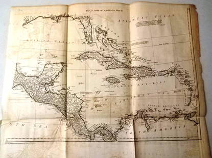
Facsimile of Mitchell's 1755 map of North America
Similar Sale History
View More Items in Maps & AtlasesRelated Maps & Atlases
More Items in Maps & Atlases
View MoreRecommended Transportation & Travel Collectibles
View More


Item Details
Description
Heading:
Author: Mitchell, John
Title: The Mitchell Map of the British and French Dominions in North America 1755
Place Published: Washington
Publisher:United States Geological Survey
Date Published: 1923
Description:
Author: Mitchell, John
Title: The Mitchell Map of the British and French Dominions in North America 1755
Place Published: Washington
Publisher:United States Geological Survey
Date Published: 1923
Description:
Map printed in black and white. 66.5x95.5 cm (26¼x37½"), folding.
Reduced facsimile of the first impression of the third English edition of Map of the British and French dominions in North America. John Mitchell's monumental map of North America. Mitchell's Map of the British and French Dominions in North America is widely regarded as the most important map in American History. Prepared on the eve of the French & Indian War, it was the second large format map of North America printed by the British and included the best up to date information of the region. This facsimile issued in the U.S.G.S. Bulletin 689, Plate III.
Condition
Fine or nearly so.
Buyer's Premium
- 25%
Facsimile of Mitchell's 1755 map of North America
Estimate $300 - $500
1 bidder is watching this item.
Shipping & Pickup Options
Item located in San Francisco, CA, usSee Policy for Shipping
Payment

Related Searches
TOP


![A block puzzle with maps of Europe, England, Ireland, Scotland, America and the World: [BLOCK PUZZLE] Boxed set of 20 cubical blocks, each face with a portion of one of six hand-colored lithographed maps. Probably Irish: mid-nineteenth century. Blocks overall 7 5/8 x 6 1/4 inches (19.5](https://p1.liveauctioneers.com/292/330597/178279620_1_x.jpg?height=310&quality=70&version=1716409282)


![[MAP]. TODESCHI, Pietro. [Nova et Acurata Totius Americae Tabula auct. G.I. Blaeu] America quarta: [MAP]. TODESCHI, Pietro. [Nova et Acurata Totius Americae Tabula auct. G.I. Blaeu] America quarta pars orbis quam plerunq, nuvum orbem appellitant primo detecta est anno 1492 a Christophoro Columbo...](https://p1.liveauctioneers.com/197/329395/177650542_1_x.jpg?height=310&quality=70&version=1715364962)


![[MAPS]. HOMANN, Johann Baptist, HOMANN HEIRS, and Georg Matthäus SEUTTER. [Composite Atlas].: [MAPS]. HOMANN, Johann Baptist (1663-1724), HOMANN HEIRS, and Georg Matthäus SEUTTER (1678-1757). [Composite Atlas]. [Nuremberg, Augsburg, and others: Homann Heirs and others, maps dated between](https://p1.liveauctioneers.com/197/329395/177650530_1_x.jpg?height=310&quality=70&version=1715364962)


![[MAP]. ORTELIUS, Abraham. Turcici Imperii Descriptio.1592.: [MAP]. ORTELIUS, Abraham (1527-1598). Turcici Imperii Descriptio. Antwerp, 1592. Engraved map with hand-coloring. Matted, framed, and double glazed, sight 406 x 521 mm (unexamined out of frame). Decor](https://p1.liveauctioneers.com/197/329395/177650538_1_x.jpg?height=310&quality=70&version=1715364962)
![[MAP]. ORTELIUS, Abraham. Americae Sive Novi Orbis, Nova Descriptio. 1573.: [MAP]. ORTELIUS, Abraham (1527-1598). Americae Sive Novi Orbis, Nova Descriptio. Antwerp, 1573. Engraved map with hand-coloring. Framed and double glazed, visible area 375 x 521 mm (unexamined out of](https://p1.liveauctioneers.com/197/329395/177650534_1_x.jpg?height=310&quality=70&version=1715364962)

![[MAP]. ORTELIUS, Abraham. Aevi Veteris, Typus Geographicus. 1601.: [MAP]. ORTELIUS, Abraham (1527-1598). Aevi Veteris, Typus Geographicus. Antwerp, 1601. Engraved map with hand-coloring. Matted, framed, and double glazed, visible area 343 x 470 mm (unexamined out of](https://p1.liveauctioneers.com/197/329395/177650532_1_x.jpg?height=310&quality=70&version=1715364962)


![[FLAGS]. 31-star American parade flag. Ca 1850-1859.: [FLAGS]. 31-star American parade flag. Ca 1850-1859. 22 x 36 1/2 in. cotton flag with 31 printed stars, configured in a double medallion surrounding a much larger central star, that is haloed in both](https://p1.liveauctioneers.com/197/329785/177758218_1_x.jpg?height=310&quality=70&version=1715625218)


