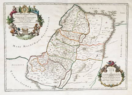
de la Rue: Antique Map of Holy Land, 1730
Similar Sale History
View More Items in Maps & AtlasesRelated Maps & Atlases
More Items in Maps & Atlases
View MoreRecommended Transportation & Travel Collectibles
View More


Item Details
Description
The later Covens & Mortier edition of de la Rue's scarce and fascinating map of the Holy Land, depicting the "Kingdom of the Jews divided by the sons of Herod the Great into tetrarchies at the time of Christ." Highly detailed with many place names, the map is said in the cartouche to be based on the Books of Maccabees, the works of Josephus, and others. Originally issued in de la Rue's La Terre Sainte en Six Cartes Geographiques, published in Paris by Mariette in 1651.
Shipping:
Your purchase is protected:
Photos, descriptions, and estimates were prepared with the utmost care by a fully certified expert and appraiser. All items in this sale are guaranteed authentic.
In the rare event that your purchase from this auction does not meet your expectations, Jasper52 specialists are here to help. If the item did not conform to the lot description in the sale, U.S. buyers may return the item for a full refund provided you notify Jasper52 within 5 days of receiving the item.
Condition
old color; overall age toning; some browning and staining along outer edges of margins; some creasing along centerfold.?
Buyer's Premium
- 10%
de la Rue: Antique Map of Holy Land, 1730
Estimate $155 - $175
3 bidders are watching this item.
Shipping & Pickup Options
Item located in New York, USSee Policy for Shipping
Payment
See More Items From This Jasper52 Seller

Auction Curated By

Maps Expert
TOP


![Océanique Iles de la Société #42 Tahiti Rangiroa Polynesia VANDERMAELEN 1827 map: CAPTION PRINTED BELOW PICTURE: Océanique - Archipel des iles de la Société [Note sur l'Archipel des îles de la Société] - No. 42 Part of the Society islands of French Pol](https://p1.liveauctioneers.com/5584/326888/175994371_1_x.jpg?height=310&quality=70&version=1713903186)

![Isles de la Reine Charlotte. Nendo, Santa Cruz, Solomon Islands. BONNE 1790 map: TITLE/CONTENT OF MAP: [Voyage du Capitaine Carteret] Isles de la Reine Charlotte // Isle du Lord Egmont ou Nouvelle Grenesey // Isle de Carteret // Baye de L'Hirondelle // Havre de Byron [Voyage of Ca](https://p1.liveauctioneers.com/5584/326888/175994487_1_x.jpg?height=310&quality=70&version=1713903186)
![Isles de la Reine Charlotte. Nendo, Santa Cruz, Solomon Islands. BONNE 1788 map: TITLE/CONTENT OF MAP: [Voyage du Capitaine Carteret] Isles de la Reine Charlotte // Isle du Lord Egmont ou Nouvelle Grenesey // Isle de Carteret // Baye de L'Hirondelle // Havre de Byron [Voyage of Ca](https://p1.liveauctioneers.com/5584/326888/175994471_1_x.jpg?height=310&quality=70&version=1713903186)
![Isles de la Société. Society Islands. Huaheine Raiatea Polynesia. BONNE 1788 map: TITLE/CONTENT OF MAP: [Cook 3e Voyage] Carte des Isles de la Société // Isle de Noël // Havre d'Owarre dans Huaheine // Havre d'Oopoa dans Ulietea // Havre d'Ohamaneno dans Ulietea [Coo](https://p1.liveauctioneers.com/5584/326888/175994425_1_x.jpg?height=310&quality=70&version=1713903186)
![Océanique Iles de la Société #42 Tahiti Rangiroa Polynesia VANDERMAELEN 1827 map: CAPTION PRINTED BELOW PICTURE: Océanique - Archipel des iles de la Société [Note sur l'Archipel des îles de la Société] - No. 42 Part of the Society islands of French Pol](https://p1.liveauctioneers.com/5584/326888/175994674_1_x.jpg?height=310&quality=70&version=1713903186)
![Carte réduite de la Mer du Sud'. Pacific Ocean. BELLIN/SCHLEY 1757 old map: CAPTION PRINTED BELOW PICTURE: Carte réduite de la Mer du Sud [Map of the South Seas] Pacific Ocean DATE PRINTED: 1757 IMAGE SIZE: Approx 22.0 x 37.0cm, 8.75 x 14.5 inches (Large); Please note th](https://p1.liveauctioneers.com/5584/326888/175994494_1_x.jpg?height=310&quality=70&version=1713903186)
![Carte réduite de la Mer du Sud'. South Pacific. Australia. BELLIN 1753 map: CAPTION PRINTED BELOW PICTURE: Carte réduite de la Mer du Sud [Map of the South Seas] DATE PRINTED: 1753 IMAGE SIZE: Approx 21.5 x 37.0cm, 8.5 x 14.5 inches (Large); Please note that this is a fo](https://p1.liveauctioneers.com/5584/326888/175994441_1_x.jpg?height=310&quality=70&version=1713903186)

![Carte de l'Isle de la Martinique'. French West Indies. BELLIN 1759 old map: CAPTION PRINTED BELOW PICTURE: Carte de l'Isle de la Martinique [Map of the island of Martinique] DATE PRINTED: 1759 IMAGE SIZE: Approx 21.5 x 32.5cm, 8.5 x 12.75 inches (Large); Please note that this](https://p1.liveauctioneers.com/5584/327764/176591093_1_x.jpg?height=310&quality=70&version=1714507756)

![Carte de l'Isle de la Grenade'. Grenada. West Indies. BELLIN 1759 old map: CAPTION PRINTED BELOW PICTURE: Carte de l'Isle de la Grenade [Map of the island of Grenada] DATE PRINTED: 1759 IMAGE SIZE: Approx 22.0 x 16.0cm, 8.5 x 6.25 inches (Medium) TYPE: Antique copperplate ma](https://p1.liveauctioneers.com/5584/327764/176590725_1_x.jpg?height=310&quality=70&version=1714507756)
![Carte de l'Isle de la Barbade'. Barbados. West Indies. BELLIN 1759 old map: CAPTION PRINTED BELOW PICTURE: Carte de l'Isle de la Barbade [Map of the Island of Barbados] DATE PRINTED: 1759 IMAGE SIZE: Approx 21.5 x 16.5cm, 8.25 x 6.5 inches (Medium) TYPE: Antique copperplate m](https://p1.liveauctioneers.com/5584/327764/176591208_1_x.jpg?height=310&quality=70&version=1714507756)
![Carte de l'Isle de la Guadeloupe', Marie-Galante & Saintes. BELLIN 1759 map: CAPTION PRINTED BELOW PICTURE: Carte de l'Isle de la Guadeloupe [Map of the island of Guadeloupe] DATE PRINTED: 1759 IMAGE SIZE: Approx 21.5 x 32.0cm, 8.5 x 12.5 inches (Large); Please note that this](https://p1.liveauctioneers.com/5584/327764/176590682_1_x.jpg?height=310&quality=70&version=1714507756)

![Océanique. Nouvelle Caledonie #46. New Caledonia Vanuatu. VANDERMAELEN 1827 map: CAPTION PRINTED BELOW PICTURE: Océanique - Nouvelle Caledonie [Note sur l'île de la Nouvelle Calédonie] - No. 46 New Caledonia and the adjacent islands to the north west including part](https://p1.liveauctioneers.com/5584/326888/175994476_1_x.jpg?height=310&quality=70&version=1713903186)


![[Maps] Gio. Ant. Magnini, Italia, 1620: [Maps] Gio. Ant. Magnini, Italia, 1620, Giovanni Antonio Magnini. Italia, data in luce da Fabio suo figliuolo al Serenissimo Ferdinado Gonzaga Duca di Matoua edi Monserrato etc. Bologna, for Sebastian](https://p1.liveauctioneers.com/188/326797/176317457_1_x.jpg?height=310&quality=70&version=1713847031)


