


Rare Gastaldi Map of the Middle East
Similar Sale History
View More Items in Maps & Atlases![Gastaldi Map of Africa: *** START PRICE IS THE RESERVE *** [Africa]. GASTALDI, Giacomo (1500-1566) & FORLANI, Paolo (fl. 1560-1571). La Descrittione dell'Africa. Engraved Map. Venice: Paolo Forlani, 1562. 19 x 25 1/4 inches](https://p1.liveauctioneers.com/1968/163248/82424552_1_x.jpg?height=310&quality=70&version=1583340284)


Related Maps & Atlases

![[MAP]. ORTELIUS, Abraham. Turcici Imperii Descriptio.1592.: [MAP]. ORTELIUS, Abraham (1527-1598). Turcici Imperii Descriptio. Antwerp, 1592. Engraved map with hand-coloring. Matted, framed, and double glazed, sight 406 x 521 mm (unexamined out of frame). Decor](https://p1.liveauctioneers.com/197/329395/177650538_1_x.jpg?height=310&quality=70&version=1715364962)


![LSE POVERTY OS PROOF MAP East End - Limehouse - Shadwell - Wapping 1928: CAPTION PRINTED BELOW PICTURE: [Ordnance Survey] Edition of 1916 - London Sheet V. 12. East End - Limehouse - Shadwell - Wapping - Stepney Green - An original unpublished “poverty map” wor](https://p1.liveauctioneers.com/5584/332390/179263082_1_x.jpg?height=310&quality=70&version=1717528223)


![Trinity County Mines (Wall) Map, 1894, Cowden, Johnson [177508]: Large wall map, 3 x 5 feet, varnish, cloth backed, excellent condition. Incredible, and rare map, shaded relief, shows 160 of the most important mines and mine owners, plus owners of all private parce](https://p1.liveauctioneers.com/2699/331495/178785752_1_x.jpg?height=310&quality=70&version=1717094933)


![Early French Map of East Coast & Canada [179301]: This is a circa 1790 French map of the Eastern Seaboard of America and parts of Canada. Landmarks and waterways are clearly marked as are the territories inhabited by Indian tribes, including the Iroq](https://p1.liveauctioneers.com/2699/331495/178785745_1_x.jpg?height=310&quality=70&version=1717094933)
More Items in Maps & Atlases
View More![[MAPS]. HOMANN, Johann Baptist, HOMANN HEIRS, and Georg Matthäus SEUTTER. [Composite Atlas].: [MAPS]. HOMANN, Johann Baptist (1663-1724), HOMANN HEIRS, and Georg Matthäus SEUTTER (1678-1757). [Composite Atlas]. [Nuremberg, Augsburg, and others: Homann Heirs and others, maps dated between](https://p1.liveauctioneers.com/197/329395/177650530_1_x.jpg?height=310&quality=70&version=1715364962)
![[MAP]. TODESCHI, Pietro. [Nova et Acurata Totius Americae Tabula auct. G.I. Blaeu] America quarta: [MAP]. TODESCHI, Pietro. [Nova et Acurata Totius Americae Tabula auct. G.I. Blaeu] America quarta pars orbis quam plerunq, nuvum orbem appellitant primo detecta est anno 1492 a Christophoro Columbo...](https://p1.liveauctioneers.com/197/329395/177650542_1_x.jpg?height=310&quality=70&version=1715364962)
![[MAP]. ORTELIUS, Abraham. Americae Sive Novi Orbis, Nova Descriptio. 1573.: [MAP]. ORTELIUS, Abraham (1527-1598). Americae Sive Novi Orbis, Nova Descriptio. Antwerp, 1573. Engraved map with hand-coloring. Framed and double glazed, visible area 375 x 521 mm (unexamined out of](https://p1.liveauctioneers.com/197/329395/177650534_1_x.jpg?height=310&quality=70&version=1715364962)


![Set of Twelve Satirical Anthropomorphic Maps of Europe: [SATIRICAL MAPS] A set of twelve satirical anthropomorphic maps of Europe. London: circa 1868. A set of 12 (believed complete) lithographed maps by Vincent Brooks, Day & Son, London, each offering](https://p1.liveauctioneers.com/292/330597/178279264_1_x.jpg?height=310&quality=70&version=1716409282)


![[MAP]. ORTELIUS, Abraham. Romani Imperii Imago. 1592.: [MAP]. ORTELIUS, Abraham (1527-1598). Romani Imperii Imago. Antwerp, 1592. Engraved map with hand-coloring. Matted, framed, and double glazed, visible area 381 x 521 mm (unexamined out of frame). 6 de](https://p1.liveauctioneers.com/197/329395/177650537_1_x.jpg?height=310&quality=70&version=1715364962)
![[MAP]. SPEED, John. A New Mappe of the Romane Empire. 1676.: [MAP]. SPEED, John (ca 1551-1629). A New Mappe of the Romane Empire. London: Basset & Chiswell, 1676. Engraved map with hand-coloring. Framed and double glazed, sight 419 x 559 mm. Decorative cartouch](https://p1.liveauctioneers.com/197/329395/177650541_1_x.jpg?height=310&quality=70&version=1715364962)

Recommended Transportation & Travel Collectibles
View More


Item Details
Description
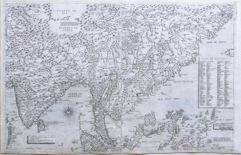
Il disegno della seconda parte dell’Asia.
Giacomo Gastaldi (c. 1500-1566).
Engraved Map, Two sheets joined.
Venice: 1561.
22 x 31 inches sheet. EXCEPTIONALLY FINE EXAMPLE OF A VERY RARE MAP: THE FIRST
ACCURATELY DRAWN
LARGE-SCALE MAP OF THE
MIDDLE-EAST
Part two, of three maps of Asia by Gastaldi, published between 1559 and 1561. It covers the modern geographical areas of Egypt, Ethiopia, Somalia, Saudi Arabia, Yemen, Oman, the United Arab Emirates, part of Iraq and Iran, Pakistan and the west coast of India.
The published travels of Marco Polo, that had appeared in Ramusio’s “Navigationi et viaggi” heavily influence Gastaldi’s geography of this map, which is considered to be far superior to all previous maps of Asia.
Buyer's Premium
- 27%
Rare Gastaldi Map of the Middle East
Estimate $30,000 - $50,000
2 bidders are watching this item.
Shipping & Pickup Options
Item located in New York, NY, usSee Policy for Shipping
Payment

Related Searches
TOP