


Pirro Ligorio's Rare Map of Greece
Similar Sale History
View More Items in Maps & Atlases![Gastaldi Map of Africa: *** START PRICE IS THE RESERVE *** [Africa]. GASTALDI, Giacomo (1500-1566) & FORLANI, Paolo (fl. 1560-1571). La Descrittione dell'Africa. Engraved Map. Venice: Paolo Forlani, 1562. 19 x 25 1/4 inches](https://p1.liveauctioneers.com/1968/163248/82424552_1_x.jpg?height=310&quality=70&version=1583340284)


Related Maps & Atlases


![De Bry & Vopel Map of the Rhine River: DE BRY, Theodor de (1528-1598) after Caspar Vopel (1511–1561). [Rhine River Map] Rheni Tricornis et Vvidi Nova et Germana Descriptio, Additis Fluminibus... Engraved map. Frankfurt: T. de Bry, 1594.](https://p1.liveauctioneers.com/1968/330639/178336641_1_x.jpg?height=310&quality=70&version=1716827770)

More Items in Italian Maps & Atlases
View More


Recommended Transportation & Travel Collectibles
View More


![[FLAGS]. 31-star American parade flag. Ca 1850-1859.: [FLAGS]. 31-star American parade flag. Ca 1850-1859. 22 x 36 1/2 in. cotton flag with 31 printed stars, configured in a double medallion surrounding a much larger central star, that is haloed in both](https://p1.liveauctioneers.com/197/329785/177758218_1_x.jpg?height=310&quality=70&version=1715625218)


Item Details
Description
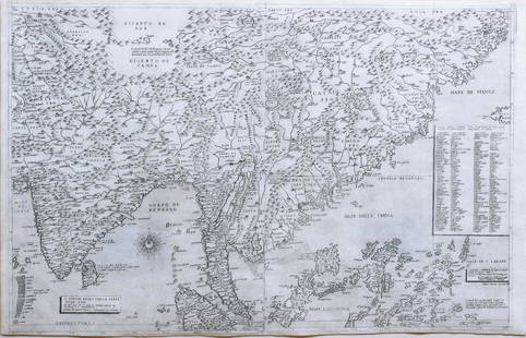
Vedrai diusi I termini di tutta la Grecia. Pirro Ligorio (c.1513/4-1583). Engraved map by Sebastiano di R‚. Rome: Michele Tramezzino, 1561. 18 3/4 x 27 inches sheet, 32 1/2 x 42 inches framed
A VERY RARE AND IMPORTANT MAP OF GREECE. It was devised by the great antiquarian and architect Pirro Ligorio, who was then associated with the Rome workshop that Michele Tramezzino operated with his older brother Francesco. The map was completed while Ligorio was restoring various churches and villas for Pope Pius IV, having earlier been expelled from St. Peter's by an ill-tempered Michelangelo. Roberto Almagia… referred to this map as "a very remarkable production", that presents Greece in a unique geographical form, epistemologically independent of other contemporary maps. The beautiful engraving by Sebastiano di R‚ grants the viewer an Apollonian view of all Hellenistic lands from the Adriatic to Asia Minor. The heavily detailed perspective features the numerous mountains, towns and islands in which the theatre of Classical mythology was acted out. This map was copied by Gerard de Jode of Antwerp in his 1578 and 1593 maps of Greece. Karrow no, Tooley:1939 no.283, Woodward:1996 watermark 194, Zacharakis no.1368.
Pirro Ligorio's minutely detailed, large-scale, erudite map of Greece was first published in 1561 by Rome-based publisher Michele Tramezzini. The map shows the entire Aegean world, encompassing a plethora of place names both ancient and modern. It stretches from the Adriatic coast in the west (with the heel of the Italian peninsula at far left) to Asia Minor (present-day western Turkey) in the east, and north from Constantinople (today Istanbul) at the entrance to the Black Sea, to Crete in the south.
Ligorio's map was one of the most complete, exhaustive, and accurate maps of the region from the sixteenth century, and many later cartographers based their own maps of Greece upon it. In the 1570s, Abraham Ortelius, publisher of the Theatrum Orbis Terrarum -- the first modern atlas -- included a map of Greece that was heavily dependent on Ligorio's work, and Gerard De Jode, publisher of the Speculum Orbis Terrarum, also used a very close copy of it. The map, which shows all of Greece and much of Asia Minor, was beautifully engraved by Sebastiano di R‚ to show Ligorio's meticulous detail. Like the great majority of sixteenth-century Italian maps, this work was never meant to be colored, for it was thought that the addition of watercolor pigment would obscure the fine engraving -- a skill for which Italian craftsmen were particularly renowned.
Pirro Ligorio was a brilliant and eccentric cartographer of the Renaissance. A polymath, he was also a learned antiquarian, architect, author, painter, and engineer. Ligorio was born in Naples around 1513 or 1514, and came to Rome around 1534 to further his artistic training. He found his true calling in the Eternal City as an investigator of Roman antiquities. His classical learning was considerable, and the maps he produced, like this one of Greece, often harmonize ancient and contemporary geographical knowledge. This map, for example, includes the names of ancient cities and sites, many of which were known only from ancient texts (most notably the geographical writings of Ptolemy and Strabo), alongside contemporary places that existed in Ligorio's lifetime. Unlike many sixteenth-century maps of Greece, Ligorio's map was not derivative but rather a work of considerable originality. Roberto AlmagiÂ…, the foremost twentieth-century authority on Italian cartography, called it a "general map of ancient and modern Greece rich in toponyms and information? a very remarkable production."
This particular example of Ligorio's map was included in an atlas issued by Antonio Lafreri, an entrepreneur who did not draft maps but instead operated as publisher and merchant. Lafreri had a prolific output of material with a particular emphasis on matter relating to Rome. In building his inventory he collected previously published plates as well as commissioning artists and engravers to produce new ones. One of Lafreri's major innovations was to assemble and bind collections of maps, focusing on works by the most noted contemporary cartographers. These volumes, each made to order for specific collector such that no two were alike, have therefore been termed composite atlases (or sometimes "Lafreri atlases," although other publishers also issued them). Many extremely rare maps have survived only because they were bound by Lafreri, and thereby protected from damaging light, moisture, and general neglect. Such is the case with this fine and rare example of Ligorio's map of Greece, which is in exceptional condition.
Born Antoine Lafrere, in Besane on in Burgundy, France, Lafreri settled in the papal city around 1540. From 1553 to 1562, he worked in partnership with Antonio Salamanca, and for a brief time after the latter's death, his son Francesco Salamanca. In 1563, that partnership came to an end and Lafreri was left in control of the firm, which he built up to become the largest of the Rome map- and print-sellers and publishers of the sixteenth century. In a sense, then, this map represents a collaborative effort of Ligorio and Lafreri: two luminary figures in Italian sixteenth-century cartography.
References: R.V. Tooley, "Maps in Italian Atlases of the Sixteenth Century," Imago Mundi 3 (1939), n. 283; Roberto AlmagiÂ…, Carte geografiche a stampa di particolare pregio o raritÂ… dei secoli XVI e XVII esistenti nella Biblioteca apostolica vaticana (Vatican City, 1948), 45; Robert AlmagiÂ…, "Pirro Ligorio cartografo," Accademia Nazionale dei Lincei; Classe di scienze morali, storiche e filologiche, Rendiconti ser. 8, 11 (1956): 57-9; Robert W. Karrow, Jr., Mapmakers of the Sixteenth Century and Their Maps: Bio-Bibliographies of the Cartographers of Abraham Ortelius, 1570 (Chicago, 1993), p. 354, n. 51/10.
Buyer's Premium
- 27%
Pirro Ligorio's Rare Map of Greece
Estimate $20,000 - $25,000
3 bidders are watching this item.
Shipping & Pickup Options
Item located in New York, NY, usSee Policy for Shipping
Payment

Related Searches
TOP