


(2) 1893 MAP U.S. INDIAN TERRITORIES & WATER MAP
Similar Sale History


Recommended Items


![1st US juvenile on trans-Mississippi west 1830: Heading: Author: [Snelliing, William] Title: Tales of Travels West of the Mississippi. By Solomon Bell Place Published: Boston Publisher:Gray & Bowen Date Published: 1830 Description:](https://p1.liveauctioneers.com/642/326037/175553683_1_x.jpg?height=310&quality=70&version=1713477451)


Item Details
Description
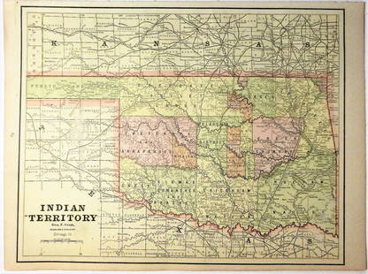
(lot of 2) Framed "Map of Aboriginal America Showing the Distribution and Territorial Limits of The Indian Nations, In The New World", taken from the "Columbian Atlas of the World We Live In", Hunt & Eaton, New York, 1893, sight: 9.5"h, 11.75"w, together with (1) unframed matted 1890 map, United States Department of Agriculture, showing location of artesian wells and others in several western states including portions of Teas, New Mexico, Indian Territory, sight: 15"h, 18.75"w, overall: 18.25"h, 11"w, total 2.5lbs Start Price: $60.00
Buyer's Premium
- 23%
(2) 1893 MAP U.S. INDIAN TERRITORIES & WATER MAP
Estimate $80 - $150
3 bidders are watching this item.
Shipping & Pickup Options
Item located in Austin, TX, usSee Policy for Shipping
Payment

Related Searches
TOP