


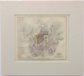
Map of Jerusalem. Keren HaYesod, 1935
Similar Sale History

![Keren Hayesod Poster - Day of Immigration and Settlement: "Yom HaAliyah VeHaHityashvut" [Day of Immigration and Settlement], poster issued by Keren Hayesod. [Tel-Aviv]: Lith. "Aviva", 1950. Design: [David] Schneuer (signed in the plate).Illustrated poster is](https://p1.liveauctioneers.com/3506/261051/135897141_1_x.jpg?height=310&quality=70&version=1662650556)


Recommended Items


Item Details
Description
Map of Jerusalem, bird's eye view, by architect and engineer Maximilian Romanov, published by the central bureau of the Keren HaYesod. Jerusalem, 1935.
Underneath the map there is a list of sites and institutions from the beginning of the Jewish settlement in Palestine: Bezalel, Hebrew Gymansium, Jerusalem War Cemetery, Beit Medrash L'Morim HaIvri, Chevrat Hachsharat HaYishuv, and more. Pasted to the back: geographic map of Palestine made by cartographer M. Eini, Cheshvan, 1938.
Size: 44x64 cm.
Fold marks, fine condition.Â
Buyer's Premium
- 20% up to $100,000.00
- 18% up to $200,000.00
- 15% above $200,000.00
Map of Jerusalem. Keren HaYesod, 1935
Estimate $200 - $250
1 bidder is watching this item.
Shipping & Pickup Options
Item located in Jerusalem, ilSee Policy for Shipping
Payment

Related Searches
TOP