


The first map of Maine that had any claim to
Similar Sale History


![Ortelius: First Map of Japan in European Atlas, 1595: Title: Iaponiae Insulae Descriptio. Ludoico Teisera Auctore. [first map of Japan published in European atlas] Map maker: Abraham Ortelius, Theatrum Orbis Terrarum Place and Year: Antwerp, 1595 Dimensi](https://p1.liveauctioneers.com/5584/108292/55552479_1_x.jpg?height=310&quality=70&version=1503667951)


![MAPS - Maine. U.S. Gov.: Maine. U.S. Gov., [Lot of 2] Map of the Northern Part of the State of Maine and of the Adjacent British Provinces... [and] Extract from a Map of the British and French Dominions in North America, 1838](https://p1.liveauctioneers.com/6576/142214/71976779_1_x.jpg?height=310&quality=70&version=1557929467)

![[MANUSCRIPT MAP-MAINE] CHADWICK, JOSEPH. Plan of part of the lands belonging to the Heirs of Brigd.r: [MANUSCRIPT MAP-MAINE] CHADWICK, JOSEPH. Plan of part of the lands belonging to the Heirs of Brigd.r Waldo ... measured by Joseph Chadwick Nov.r 1765. [New England]: November, 1765. Manuscript survey](https://p1.liveauctioneers.com/292/250642/130213647_1_x.jpg?height=310&quality=70&version=1654271664)


Recommended Items

![Horn Silver Mine Report [181931]: "The Horn Silver Mine Report," W.A. Hooker, E.M., March 1879. 14 maps & plans, most with color; 5 duotone lithographed plates with views. 32 pp. 8.5" x 10.5". Some chipping on page and wrapper edges,](https://p1.liveauctioneers.com/2699/331499/178846268_1_x.jpg?height=310&quality=70&version=1717095214)

![Norwegia by Bertius / Langenes. The first map to show Norway seperately 1603: CAPTION PRINTED BELOW PICTURE: Descriptio Norwegiae et Suecia / Norwegia [Norway] The map is orientated to the west DATE PRINTED: 1603 IMAGE SIZE: Approx 10.5 x 17.0cm, 4.25 x 6.5 inches (Small) TYPE:](https://p1.liveauctioneers.com/5584/332390/179263141_1_x.jpg?height=310&quality=70&version=1717528223)
![Cartographers Silver Medal [179723]: Rare silver medal honoring the cartographers who were the first map makers to use the name America (after Amerigo Vespucci). Obv.: Ringmann-Lud Waldeseemuller / Alteurs / De La Cosmographia Introducti](https://p1.liveauctioneers.com/2699/331499/178846389_1_x.jpg?height=310&quality=70&version=1717095214)

![[Maps & Atlases] Speed, John: The Turkish Empire: [Maps & Atlases] Speed, John: The Turkish Empire Speed, John The Turkish Empire (London): Roger Rea the Elder and younger, 1626 (but, 1662 or after). Engraved hand-colored map, 16 3/4 x 21 1/2 in. (42](https://p1.liveauctioneers.com/65/332523/179335176_1_x.jpg?height=310&quality=70&version=1717709446)


![Claim Map of the Middle Section of the Comstock, c1920 [173201]: 31 x 56" black ink on velum original claim map, 1" to 100', for the Comstock Merger Mines Inc. this map shows the gut of the Comstock from the best and belcher on the right (north) to the exchquer (so](https://p1.liveauctioneers.com/2699/331499/178846246_1_x.jpg?height=310&quality=70&version=1717095214)


Item Details
Description
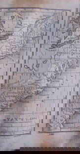
A Map of the District of Maine, Drawn from the latest Surveys and other best Authorities. Osgood Carleton (18th century). From James Sullivan, The History of the District of Maine. Engraved map. Boston, 1795. 21 3/4 x 17 1/2 inches sheet. The first map of Maine that had any claim to completeness and accuracy, with greater detail than the near contemporary maps published by Matthew Carey and Scott for their atlases.
Buyer's Premium
- 25%
The first map of Maine that had any claim to
Estimate $1,500 - $2,000
3 bidders are watching this item.
Shipping & Pickup Options
Item located in New York, NY, usSee Policy for Shipping
Payment

Related Searches
TOP