


N.E. View of St. Catherines Harbor, Brazil, by Pirate G. Anson (1756)
Similar Sale History
View More Items in Maps & Atlases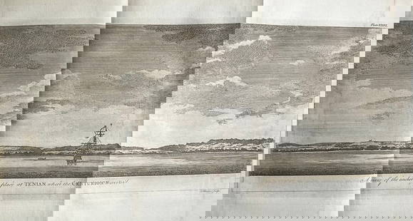


![The Tower [of London] & St Catherin's'. St Katherine's: TITLE/CONTENT OF MAP: 'The Tower and St Catherin's' The Tower of London and adjacent area The top image on the right hand side shows the entire map. To view a close up of the map showing the level of](https://p1.liveauctioneers.com/5584/192167/96862514_1_x.jpg?height=310&quality=70&version=1611703298)
![Des Barres Map of NY Harbor: *** START PRICE IS THE RESERVE *** [America] DES BARRES, Joseph Frederick Wallet (1729-1824). A Chart of New York Harbour with the Soundings Views of Land Marks and Nautical directions for the Use of](https://p1.liveauctioneers.com/1968/163248/82424572_1_x.jpg?height=310&quality=70&version=1583340284)
Related Maps & Atlases


![1750 Bowen Map of Bermuda and St. Kitts -- A New & Accurate Map of Bermudas or Sommer's Islands...: Title: 1750 Bowen Map of Bermuda and St. Kitts -- A New & Accurate Map of Bermudas or Sommer's Islands... [on sheet with] An Accurate Map of the Island of St. Christopher… Cartographer: E Bowen](https://p1.liveauctioneers.com/5584/330117/177981806_1_x.jpg?height=310&quality=70&version=1716324705)


More Items in Maps & Atlases
View More


![[MAP]. TODESCHI, Pietro. [Nova et Acurata Totius Americae Tabula auct. G.I. Blaeu] America quarta: [MAP]. TODESCHI, Pietro. [Nova et Acurata Totius Americae Tabula auct. G.I. Blaeu] America quarta pars orbis quam plerunq, nuvum orbem appellitant primo detecta est anno 1492 a Christophoro Columbo...](https://p1.liveauctioneers.com/197/329395/177650542_1_x.jpg?height=310&quality=70&version=1715364962)


![[MAPS]. HOMANN, Johann Baptist, HOMANN HEIRS, and Georg Matthäus SEUTTER. [Composite Atlas].: [MAPS]. HOMANN, Johann Baptist (1663-1724), HOMANN HEIRS, and Georg Matthäus SEUTTER (1678-1757). [Composite Atlas]. [Nuremberg, Augsburg, and others: Homann Heirs and others, maps dated between](https://p1.liveauctioneers.com/197/329395/177650530_1_x.jpg?height=310&quality=70&version=1715364962)

Recommended Transportation & Travel Collectibles
View More


Item Details
Description
Explore the N.E. view of St. Catherines Harbor on the coast of Brazil with this antique map by English pirate G. Anson. Published in 1756, this map is part of his renowned work "A Voyage Round the World". Anson's mission was to attack Spanish territories and loot treasure galleons, making this map a fascinating firsthand account of piracy during the Age of Exploration. Despite facing risks and losing much of his crew and ships, Anson completed a circumnavigation of the globe. Measuring approximately 18 1/2" x 11", this copperplate engraved map is in excellent condition. Its authenticity is guaranteed, providing a valuable historical artifact.
Reserve: $15.00
Shipping:
Your purchase is protected:
Photos, descriptions, and estimates were prepared with the utmost care by a fully certified expert and appraiser. All items in this sale are guaranteed authentic.
In the rare event that the item did not conform to the lot description in the sale, Jasper52 specialists are here to help. Buyers may return the item for a full refund provided you notify Jasper52 within 5 days of receiving the item.
Condition
Excellent condition
Buyer's Premium
- 15%
N.E. View of St. Catherines Harbor, Brazil, by Pirate G. Anson (1756)
Estimate $30 - $40
1 bidder is watching this item.
Shipping & Pickup Options
Item located in New York, US$14 shipping in the US
Payment
Accepts seamless payments through LiveAuctioneers
See More Items From This Jasper52 Seller

TOP