


The Hydrographic Office Chart, Position Plotting Sheet
Similar Sale History
View More Items in Maps & Atlases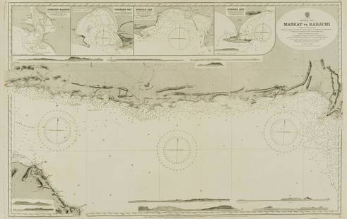


![Dudley Sea Chart of Argentina: DUDLEY, Sir Robert (1574-1649). [Argentina] Carta particolare della costa di America Australe che comincia al C. di Matas sin al C. di Galegos. Engraved map. Florence, 1646. 20 7/8" x 16 1/8" sheet. S](https://p1.liveauctioneers.com/1968/250616/130196501_1_x.jpg?height=310&quality=70&version=1654190895)
Related Maps & Atlases


![[MAP]. SARTINE, Antoine Plan de la Barre et du Havre de Charles-Town...1778. RARE REVOLUTIONARY WAR: [MAP]. SARTINE, Antoine (1729-1801). Plan de la Barre et du Havre de Charles-Town d'apres un plan Anglois leve en 1776... Paris: Depot de la Marine for M. de Sartine, 1778. Copperplate engraving, matt](https://p1.liveauctioneers.com/197/329395/177650540_1_x.jpg?height=310&quality=70&version=1715364962)


More Items in Maps & Atlases
View More


![[Maps] Gio. Ant. Magnini, Italia, 1620: [Maps] Gio. Ant. Magnini, Italia, 1620, Giovanni Antonio Magnini. Italia, data in luce da Fabio suo figliuolo al Serenissimo Ferdinado Gonzaga Duca di Matoua edi Monserrato etc. Bologna, for Sebastian](https://p1.liveauctioneers.com/188/326797/176317457_1_x.jpg?height=310&quality=70&version=1713847031)
![[Maps] Martin Zeiler, Itinerarium Italiae, 1640: [Maps] Martin Zeiler, Itinerarium Italiae, 1640, Martini Zeilleri. Itinerarium Italiae Nov-Antiquae: oder, Raiss-Beschreibung durch Italien, Matthaus Merian, Frankfurt, 40 plates, most double-page, in](https://p1.liveauctioneers.com/188/326797/176317459_1_x.jpg?height=310&quality=70&version=1713847031)


Recommended Transportation & Travel Collectibles
View More


Item Details
Description
A plotting sheet designed for open ocean navigation to add areas of importance and water depth. Publishing stamp by "The Hydrographic Office" located on bottom.
Issued: 1930
Dimensions: 22.5"L x 17.5"W
Manufacturer: The Hydrographic Office
Country of Origin: United States
Issued: 1930
Dimensions: 22.5"L x 17.5"W
Manufacturer: The Hydrographic Office
Country of Origin: United States
Condition
Age related wear.
Buyer's Premium
- 25%
The Hydrographic Office Chart, Position Plotting Sheet
Estimate $10 - $200
Get approved to bid.
Shipping & Pickup Options
Item located in Hollywood, FL, usOffers In-House Shipping
Local Pickup Available
Payment
Accepts seamless payments through LiveAuctioneers

Related Searches
TOP