


1756 Philippines Coastline Map by English Pirate G. Anson
Similar Sale History
View More Items in Maps & Atlases


Related Maps & Atlases


![WEST AFRICA Explorers' routes Senegal Ashanti. Mountains of Kong. SDUK 1857 map: Title: WEST AFRICA Explorers' routes Senegal Ashanti. Mountains of Kong. SDUK 1857 map Description: WEST AFRICA, I [Senegal River to Cape St Paul]. Engraved by J & C Walker (1857). Antique steel engra](https://p1.liveauctioneers.com/5584/330582/178266235_1_x.jpg?height=310&quality=70&version=1716924723)


More Items in Maps & Atlases
View More


![[MAP]. TODESCHI, Pietro. [Nova et Acurata Totius Americae Tabula auct. G.I. Blaeu] America quarta: [MAP]. TODESCHI, Pietro. [Nova et Acurata Totius Americae Tabula auct. G.I. Blaeu] America quarta pars orbis quam plerunq, nuvum orbem appellitant primo detecta est anno 1492 a Christophoro Columbo...](https://p1.liveauctioneers.com/197/329395/177650542_1_x.jpg?height=310&quality=70&version=1715364962)


![[MAPS]. HOMANN, Johann Baptist, HOMANN HEIRS, and Georg Matthäus SEUTTER. [Composite Atlas].: [MAPS]. HOMANN, Johann Baptist (1663-1724), HOMANN HEIRS, and Georg Matthäus SEUTTER (1678-1757). [Composite Atlas]. [Nuremberg, Augsburg, and others: Homann Heirs and others, maps dated between](https://p1.liveauctioneers.com/197/329395/177650530_1_x.jpg?height=310&quality=70&version=1715364962)


![[MAP]. ORTELIUS, Abraham. Americae Sive Novi Orbis, Nova Descriptio. 1573.: [MAP]. ORTELIUS, Abraham (1527-1598). Americae Sive Novi Orbis, Nova Descriptio. Antwerp, 1573. Engraved map with hand-coloring. Framed and double glazed, visible area 375 x 521 mm (unexamined out of](https://p1.liveauctioneers.com/197/329395/177650534_1_x.jpg?height=310&quality=70&version=1715364962)
![Set of Twelve Satirical Anthropomorphic Maps of Europe: [SATIRICAL MAPS] A set of twelve satirical anthropomorphic maps of Europe. London: circa 1868. A set of 12 (believed complete) lithographed maps by Vincent Brooks, Day & Son, London, each offering](https://p1.liveauctioneers.com/292/330597/178279264_1_x.jpg?height=310&quality=70&version=1716409282)


Recommended Transportation & Travel Collectibles
View More


![[FLAGS]. 31-star American parade flag. Ca 1850-1859.: [FLAGS]. 31-star American parade flag. Ca 1850-1859. 22 x 36 1/2 in. cotton flag with 31 printed stars, configured in a double medallion surrounding a much larger central star, that is haloed in both](https://p1.liveauctioneers.com/197/329785/177758218_1_x.jpg?height=310&quality=70&version=1715625218)


Item Details
Description
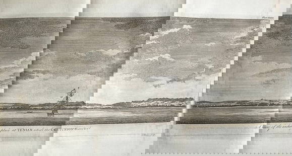
This detailed map of the Philippine coastline, created by the English pirate George Anson, is one of the largest and most accurate maps of the island nation's coastline to be produced at the time. It is also the only nation shown in its entirety in Anson's work. The map shows the route of the Manila Galleons, with a compass and rhumb lines. It was published in London in 1756 as part of Anson's book 'A Voyage Round the World', considered one of the greatest first-hand accounts of circumnavigation, adventure, and piracy from the age of exploration. Anson's mission was to attack Spanish territories in western South America and capture and plunder Spanish treasure galleons. Despite losing more than two-thirds of his crew and three of his eight ships, he succeeded in capturing the larger and better-armed Spanish treasure galleon 'Nuestra Seniora de Cobadonga' off Cape Espiritu Santo, Samar Island, Philippines in 1743. He was later promoted to Lord of the British Crown and became one of the top English commanders during the Seven Years' War. The map is a copper engraved, measures 28 x 21 1/2 inches, and is in excellent condition. Its authenticity is guaranteed.
Reserve: $120.00
Shipping:
Your purchase is protected:
Photos, descriptions, and estimates were prepared with the utmost care by a fully certified expert and appraiser. All items in this sale are guaranteed authentic.
In the rare event that the item did not conform to the lot description in the sale, Jasper52 specialists are here to help. Buyers may return the item for a full refund provided you notify Jasper52 within 5 days of receiving the item.
Condition
Excellent condition
Buyer's Premium
- 15%
1756 Philippines Coastline Map by English Pirate G. Anson
Estimate $200 - $250
1 bidder is watching this item.
Shipping & Pickup Options
Item located in New York, US$12 shipping in the US
Payment
Accepts seamless payments through LiveAuctioneers
See More Items From This Jasper52 Seller

TOP