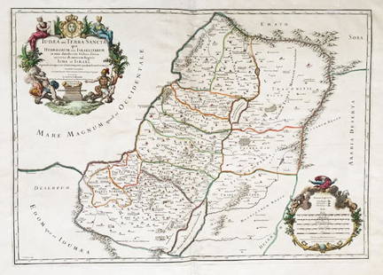
Antique Map of The Holy Land, Dated 1792
Similar Sale History
View More Items in Maps & AtlasesRelated Maps & Atlases
More Items in Maps & Atlases
View MoreRecommended Transportation & Travel Collectibles
View More


Item Details
Description
"Generaale Kaart Van Het Beloofde Land" colored map of The Holy Land, covering present-day Israel and Palestine, bordered by Egypt and Syria. Dated 1792, unframed. [22 x 26 inches]. Dry, losses, creases, folds, toning, stains.
Condition
Dry, losses, creases, folds, toning, stains.
Buyer's Premium
- 28% up to $500,000.00
- 20% up to $1,000,000.00
- 12.5% above $1,000,000.00
Antique Map of The Holy Land, Dated 1792
Estimate $100 - $300
6 bidders are watching this item.
Shipping & Pickup Options
Item located in Glen Cove, NY, usSee Policy for Shipping
Local Pickup Available
Payment
Accepts seamless payments through LiveAuctioneers

Related Searches
TOP


![[MAP]. ORTELIUS, Abraham. Presbiteri Iohannis, sive, Abissinorum Imperii Descriptio. 1592.: [MAP]. ORTELIUS, Abraham. (1527-1598). Presbiteri Iohannis, sive, Abissinorum Imperii Descriptio. Antwerp, 1592. Engraved map with hand-coloring. Matted, framed, and double glazed, visible area 406 x](https://p1.liveauctioneers.com/197/329395/177650536_1_x.jpg?height=310&quality=70&version=1715364962)


![[Maps] Gio. Ant. Magnini, Italia, 1620: [Maps] Gio. Ant. Magnini, Italia, 1620, Giovanni Antonio Magnini. Italia, data in luce da Fabio suo figliuolo al Serenissimo Ferdinado Gonzaga Duca di Matoua edi Monserrato etc. Bologna, for Sebastian](https://p1.liveauctioneers.com/188/326797/176317457_1_x.jpg?height=310&quality=70&version=1713847031)
![[Maps] Martin Zeiler, Itinerarium Italiae, 1640: [Maps] Martin Zeiler, Itinerarium Italiae, 1640, Martini Zeilleri. Itinerarium Italiae Nov-Antiquae: oder, Raiss-Beschreibung durch Italien, Matthaus Merian, Frankfurt, 40 plates, most double-page, in](https://p1.liveauctioneers.com/188/326797/176317459_1_x.jpg?height=310&quality=70&version=1713847031)


![[MAP]. TODESCHI, Pietro. [Nova et Acurata Totius Americae Tabula auct. G.I. Blaeu] America quarta: [MAP]. TODESCHI, Pietro. [Nova et Acurata Totius Americae Tabula auct. G.I. Blaeu] America quarta pars orbis quam plerunq, nuvum orbem appellitant primo detecta est anno 1492 a Christophoro Columbo...](https://p1.liveauctioneers.com/197/329395/177650542_1_x.jpg?height=310&quality=70&version=1715364962)


