[MAP]. FRY & JEFFERSON. A Map of the Most Inhabited Part of Virginia. 1775. FIRST PRINTED MAP OF
Similar Sale History
View More Items in Maps & AtlasesRelated Maps & Atlases
More Items in Maps & Atlases
View MoreRecommended Transportation & Travel Collectibles
View More


![[MAP]. FRY & JEFFERSON. A Map of the Most Inhabited Part of Virginia. 1775. FIRST PRINTED MAP OF](https://p1.liveauctioneers.com/197/305583/163286504_1_x.jpg?quality=1&version=1697143109&width=486)
![[MAP]. FRY & JEFFERSON. A Map of the Most Inhabited Part of Virginia. 1775. FIRST PRINTED MAP OF](https://p1.liveauctioneers.com/197/305583/163286504_1_x.jpg?quality=80&version=1697143109)
Item Details
Description
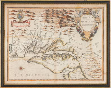
[MAPS & ATLASES]. FRY, Joshua (1699-1754) and Peter JEFFERSON (1708-1757). A Map of the Most Inhabited Part of Virginia containing the whole Province of Maryland with Part of Pensilvania, New Jersey, and North Carolina. London: Robert Sayer and Thomas Jefferys, 1775.
Engraved map of Virginia and Maryland on 4 sheets joined as two horizontal sheets, borders and waterways hand-colored in outline (a few soft vertical creases, some light browning and spotting, tiny hole in blank area of North Carolina with old repair verso). Each overall sheet 1303 x 492 mm. Framed. Cartouche by Charles Grignion after Francis Hayman depicting a wharf scene.
THE FIRST PRINTED MAP OF VIRGINIA BY VIRGINIANS, state 6 with the date changed from 1751 to 1775. Peter Jefferson (father of Thomas Jefferson) and Joshua Fry first prepared the map at the request of Lord Halifax in 1751, who had recently become the president of the board of Trade and Plantations. It was first revised in 1751, and revised again in 1755 to include information about western Virginia colony based on John Dalrymple and Christopher Gist's journals. In his autobiography, Thomas Jefferson describes his father's collaboration with Joshua Fry produced the "first map of Virginia which has ever been made, that of Captain Smith being merely a conjectural sketch." The map is the first to accurately depict the Blue Ridge Mountains and to delineate the road system in Virginia. Pritchard & Taliaferro, Degrees of Latitude, no. 30; Schwartz & Ehrenberg, Mapping of America, pp. 157–158; Stevens & Tree 87f.
Property from the Collection of Richard D. Simmons, Alexandria, VA
Buyer's Premium
- 30% up to $1,000,000.00
- 24% up to $5,000,000.00
- 19% above $5,000,000.00
[MAP]. FRY & JEFFERSON. A Map of the Most Inhabited Part of Virginia. 1775. FIRST PRINTED MAP OF
Estimate $4,000 - $6,000
18 bidders are watching this item.
Shipping & Pickup Options
Item located in Chicago, IL, usSee Policy for Shipping
Payment

Related Searches
TOP


![Europe after the Congress of Vienna. 4 sheets. 128x106cm. THOMSON 1817 old map: TITLE/CONTENT OF MAP: A map of Europe, with the political divisions after the Peace of Paris and Congress of Vienna [4 sheets] This very large map, printed on 4 sheets, shows a re-aligned Europe after](https://p1.liveauctioneers.com/5584/328641/177014440_1_x.jpg?height=310&quality=70&version=1715113718)


![Carte de l'Europe en 1789 & 1813. Napoleonic Europe. LAPIE 1831 old map: CAPTION PRINTED BELOW PICTURE: Carte de l'Europe en 1789 // Carte de l'Europe en 1813 [Europe in 1789 // Europe in 1813] DATE PRINTED: The publication date of the atlas within which this map was print](https://p1.liveauctioneers.com/5584/328641/177014437_1_x.jpg?height=310&quality=70&version=1715113718)
![Carte des Royaumes de Belgique & Hollande. Belgium Netherlands. LAPIE 1833 map: CAPTION PRINTED BELOW PICTURE: Carte des Royaumes de Belgique et de Hollande [The Kingdoms of Belgium and Holland] DATE PRINTED: The publication date of the atlas within which this map was printed is](https://p1.liveauctioneers.com/5584/328641/177014272_1_x.jpg?height=310&quality=70&version=1715113718)
![[Maps] Gio. Ant. Magnini, Italia, 1620: [Maps] Gio. Ant. Magnini, Italia, 1620, Giovanni Antonio Magnini. Italia, data in luce da Fabio suo figliuolo al Serenissimo Ferdinado Gonzaga Duca di Matoua edi Monserrato etc. Bologna, for Sebastian](https://p1.liveauctioneers.com/188/326797/176317457_1_x.jpg?height=310&quality=70&version=1713847031)
![[Maps] Martin Zeiler, Itinerarium Italiae, 1640: [Maps] Martin Zeiler, Itinerarium Italiae, 1640, Martini Zeilleri. Itinerarium Italiae Nov-Antiquae: oder, Raiss-Beschreibung durch Italien, Matthaus Merian, Frankfurt, 40 plates, most double-page, in](https://p1.liveauctioneers.com/188/326797/176317459_1_x.jpg?height=310&quality=70&version=1713847031)


![[MAP]. TODESCHI, Pietro. [Nova et Acurata Totius Americae Tabula auct. G.I. Blaeu] America quarta: [MAP]. TODESCHI, Pietro. [Nova et Acurata Totius Americae Tabula auct. G.I. Blaeu] America quarta pars orbis quam plerunq, nuvum orbem appellitant primo detecta est anno 1492 a Christophoro Columbo...](https://p1.liveauctioneers.com/197/329395/177650542_1_x.jpg?height=310&quality=70&version=1715364962)


