


1910 National Map Company Wall Map State Of New York
Similar Sale History
View More Items in Maps & Atlases


Related Maps & Atlases


![[NEW YORK CITY – PICTORIAL MAPS]. Group of 3 pictorial maps...: [NEW YORK CITY – PICTORIAL MAPS]. Group of 3 pictorial maps. Including: ANNAND, George (1890—1980). Sinclair Pictorial Map of New York/New York World’s Fair. 26 ¾ x 27 5/8”](https://p1.liveauctioneers.com/928/325952/175495562_1_x.jpg?height=310&quality=70&version=1712935174)


More Items in Maps & Atlases
View More


![[Maps] Gio. Ant. Magnini, Italia, 1620: [Maps] Gio. Ant. Magnini, Italia, 1620, Giovanni Antonio Magnini. Italia, data in luce da Fabio suo figliuolo al Serenissimo Ferdinado Gonzaga Duca di Matoua edi Monserrato etc. Bologna, for Sebastian](https://p1.liveauctioneers.com/188/326797/176317457_1_x.jpg?height=310&quality=70&version=1713847031)
![[Maps] Martin Zeiler, Itinerarium Italiae, 1640: [Maps] Martin Zeiler, Itinerarium Italiae, 1640, Martini Zeilleri. Itinerarium Italiae Nov-Antiquae: oder, Raiss-Beschreibung durch Italien, Matthaus Merian, Frankfurt, 40 plates, most double-page, in](https://p1.liveauctioneers.com/188/326797/176317459_1_x.jpg?height=310&quality=70&version=1713847031)


Recommended Transportation & Travel Collectibles
View More


Item Details
Description
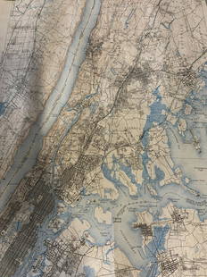
1910 roll down wall map printed by the National Map Company showing the counties, towns, roads, steamships routes etc within the State Of New York. The map which measures approximately 44" by 64" together with a supplement map by the same company. Condition - fine
Buyer's Premium
- 25%
1910 National Map Company Wall Map State Of New York
Estimate $200 - $400
1 bidder is watching this item.
Shipping & Pickup Options
Item located in East Greenbush, NY, usSee Policy for Shipping
Payment
Accepts seamless payments through LiveAuctioneers

Two Feathers Antiques & Auction Services / Schillaci & Shultis
East Schodack, NY, United States654 Followers
Related Searches
TOP