


1861 Johnson Map of Missouri and Kansas -- Johnson's Missouri and Kansas
Similar Sale History
View More Items in Maps & Atlases


Related Maps & Atlases


![1866 Johnson Map of Sweden, Norway and Denmark -- Johnson's Sweden, Norway [on sheet with] Denmark: Title: 1866 Johnson Map of Sweden, Norway and Denmark -- Johnson's Sweden, Norway [on sheet with] Denmark Cartographer: Johnson & Ward Year / Place: 1866, New York Map Dimension (in.): 15.4 X 21.2 in.](https://p1.liveauctioneers.com/5584/329422/177662257_1_x.jpg?height=310&quality=70&version=1715717898)


More Items in Maps & Atlases
View More
![[Maps] Martin Zeiler, Itinerarium Italiae, 1640: [Maps] Martin Zeiler, Itinerarium Italiae, 1640, Martini Zeilleri. Itinerarium Italiae Nov-Antiquae: oder, Raiss-Beschreibung durch Italien, Matthaus Merian, Frankfurt, 40 plates, most double-page, in](https://p1.liveauctioneers.com/188/326797/176317459_1_x.jpg?height=310&quality=70&version=1713847031)
![[Maps] Gio. Ant. Magnini, Italia, 1620: [Maps] Gio. Ant. Magnini, Italia, 1620, Giovanni Antonio Magnini. Italia, data in luce da Fabio suo figliuolo al Serenissimo Ferdinado Gonzaga Duca di Matoua edi Monserrato etc. Bologna, for Sebastian](https://p1.liveauctioneers.com/188/326797/176317457_1_x.jpg?height=310&quality=70&version=1713847031)


![[MAP]. TODESCHI, Pietro. [Nova et Acurata Totius Americae Tabula auct. G.I. Blaeu] America quarta: [MAP]. TODESCHI, Pietro. [Nova et Acurata Totius Americae Tabula auct. G.I. Blaeu] America quarta pars orbis quam plerunq, nuvum orbem appellitant primo detecta est anno 1492 a Christophoro Columbo...](https://p1.liveauctioneers.com/197/329395/177650542_1_x.jpg?height=310&quality=70&version=1715364962)


Recommended Transportation & Travel Collectibles
View More


Item Details
Description
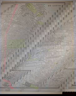
This is an attractive double-page map of Missouri and most of Kansas. It is absolutely filled with details, including proposed topography, rivers, railroad routes, trails, forts, towns, etc. The counties are color-coded. The map is adorned with three vignettes: Fire on the Prairie; Spearing Fish; and Santa Fe from the Great Missouri Trail, which shows a joyous wagon train first sighting the town. Kansas's county development is restricted to the eastern portion. Kansas just gained statehood as this map was issued and predates Worth County in Missouri. Decorative borders.
Reserve: $60.00
Shipping:
Your purchase is protected:
Photos, descriptions, and estimates were prepared with the utmost care by a fully certified expert and appraiser. All items in this sale are guaranteed authentic.
In the rare event that the item did not conform to the lot description in the sale, Jasper52 specialists are here to help. Buyers may return the item for a full refund provided you notify Jasper52 within 5 days of receiving the item.
Condition
Good to Fair. Damp staining in corners. Marginal splits. Split in issued centerfold. Hand color.
Buyer's Premium
- 15%
1861 Johnson Map of Missouri and Kansas -- Johnson's Missouri and Kansas
Estimate $70 - $80
2 bidders are watching this item.
Shipping & Pickup Options
Item located in Ohio, US$18 shipping in the US
Payment
Accepts seamless payments through LiveAuctioneers
See More Items From This Jasper52 Seller

Auction Curated By

Maps Expert
TOP