Sold20231861 Johnson Map of Missouri and Kansas -- Johnson's Missouri and KansasTitle: 1861 Johnson Map of Missouri and Kansas -- Johnson's Missouri and Kansas Cartographer: Johnson & Ward Year / Place: 1861, New York Map Dimension (in.): 17.1 X 23.1 in. This is an attractive douSee Sold Price
Sold20221866 Johnson Map of Missouri and Kansas -- Johnson's Missouri and KansasTitle: 1866 Johnson Map of Missouri and Kansas -- Johnson's Missouri and Kansas Cartographer: Johnson and Ward Year / Place: 1866, New York Map Dimension (in.): 17.1 X 23.1 in. This excellent double-pSee Sold Price
Sold20201865 Johnson Map of Missouri and Kansas -- Johnson'sTitle/Content of Map: 1865 Johnson Map of Missouri and Kansas -- Johnson's Missouri and Kansas Cartographer: A Johnson Year/Place: 1865, New York Size: 17.1 X 23.1 in. This double-page map shows all oSee Sold Price
Sold2022Scarce Johnson's Missouri & Kansas map during CivilLarge double-page map of these two states of great importance during the Civil War. One of Johnson and Ward’s more decorative issues, this map offers a fascinating snapshot of these two hotly cSee Sold Price
Sold20201861 Missouri & Kansas. By JohnsonTitle: 1861 Missouri & Kansas. By Johnson Date/Period: 1861 Materials: Steel engraved. Size: 26 x 18” 1861. By A. J. Johnson & J. H Colton. From "Johnson's New Illustrated Family Atlas' published inSee Sold Price
Sold2017Johnson: Antique Map of Missouri & Kansas, 1868Title/Content of Map: Missouri & Kansas by Johnson Date Printed: 1868 Cartographer: A.J. Johnson Material/Medium: Paper Size: 18" x 24" Hand colored steel engraved Map. From Johnson's New IllustratedSee Sold Price
Sold2020Johnson's Missouri and KansasTitle: Johnson's Missouri and Kansas Prublication Date: 1861 Cartographer: JOHNSON, ALVIN JEWETT Publisher: JOHNSON & BROWNING Size: 17Height - 23Width Additional Information: Three vignettes: IndiansSee Sold Price
Sold20231861 Missouri and Kansas. By Johnson and BrowningTitle: 1861 Missouri and Kansas. By Johnson and Browning Date/Period: 1861 Materials: Steel engraved Size: 26 x 18” Shows counties while western Kansas is not divided into counties at this pointSee Sold Price
Sold2018Johnson & Ward: Kansas & Missouri, 1864The scarce and highly detailed map of the pivotal states of Missouri and Kansas near the end of the Civil War, with western Kansas still largely unorganized. In addition to showing major transcontinenSee Sold Price
Sold2023MKT Missouri-Kansas-Texas RR Long Spout Pump Oil CanThis is a MKT (Missouri-Kansas-Texas) Railroad long spout oil can with the automatic pump feeder, in working condtition. Pump the oil via the thumb-operated lever on the can. Made by the Johnson CompaSee Sold Price
Sold20192 5/8" Johnson Bright Colorful Red, Ex Dr. Nuckles3 5/8" Johnson Bright Colorful Red, Ex Dr. Nuckles Collection, Dr Nuckles Collected in late 1800s to early 1900s, Near Kansas City, MissouriSee Sold Price
Sold2020Very important map of Nebraska & KansasTitle: Very important map of Nebraska & Kansas Date/Period: 1861 Materials: Steel engraved. Size: 18x13” 1861. By A. J. Johnson & J. H Colton. From "Johnson's New Illustrated Family Atlas' publishedSee Sold Price
Sold2019U S Coast Survey 1896 Map. Missouri & Kansas"Sketch showing Route Line of Spirit Levels" Lithograph Map Published 1896, Washington for "U.S. Coast and Geodetic Survey" Folds as issued. Rare. Paper Size: 16 x 11.5 inch (40 x 29cm) Good ConditionSee Sold Price
Sold2020U S Coast Survey 1896 Map. Missouri & Kansas"Sketch showing Route Line of Spirit Levels from Jefferson City Mo. To Holliday, Kans" Lithograph Map Published 1896, Washington for "U.S. Coast and Geodetic Survey" Folds as issued. Rare. Paper Size:See Sold Price
Sold2020JohnsonTitle/Content of Map: Johnson's Missouri and Kansas Cartographer: JOHNSON AND WARD Date: 1862 Publisher: JOHNSON AND WARD Size: 16Height - 21.5Width Map showing all of MO and the eastern half of KS. DSee Sold Price
Sold2022Scarce map of Indian Terr., Kansas, Missouri, IllinoisScarce map of a cross section of American states and hand-colored by county at the time of publishing. Shows Oklahoma Territory when it was inhabited mostly by Native American tribes. Shows forts, raiSee Sold Price
Sold2017Johnson: Map of Nebraska Dakotas Idaho Kansas, 1864Title/Content of Map: 1864 Johnson Map of Nebraska, Dakotas, Idaho and Kansas -- Johnson's Nebraska, Dakota, Colorado, Idaho, Kansas Date Printed: 1864, New York Cartographer: Johnson & Ward Size: 12.See Sold Price
Sold20221864 Johnson Map of Nebraska, Dakotas, Idaho and KansasTitle: 1864 Johnson Map of Nebraska, Dakotas, Idaho and Kansas -- Johnson's Nebraska, Dakota, Colorado, Idaho, Kansas Cartographer: Johnson & Ward Year / Place: 1864, New York Map Dimension (in.): 12.See Sold Price
Sold20221862 Johnson Map of Nebraska, Dakota, Colorado andTitle: 1862 Johnson Map of Nebraska, Dakota, Colorado and Kansas -- Johnson's Nebraska, Dakota, Colorado, & Kansas. Cartographer: Johnson and Ward Date/Place: 1862, New York Dimensions: 12.4 X 15.4 DeSee Sold Price
Sold2023Map of Kansas City, Missouri and Kansas City, KansasPublication Date: 1889 Title: Map of Kansas City, Missouri and Kansas City, Kansas Cartographer: CRAM, GEO. F. Publisher: CRAM, GEO. F. Height: 9.6 Width: 11.6 Map showing Kansas City, MO with easternSee Sold Price
Sold2023Map of Kansas City, Missouri and Kansas City, Kansas (and) St. LouisTitle: Map of Kansas City, Missouri and Kansas City, Kansas (and) St. Louis Cartographer: George F. Cram Publisher: George F. Cram Date: 1892 Description: "Kansas City" - Map with streets named, railrSee Sold Price
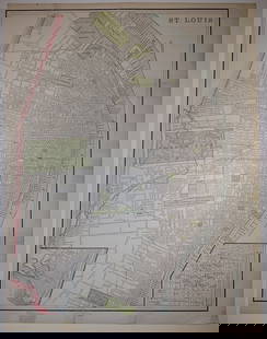
Sold2023St. Louis/Map of Kansas City, Missouri and Kansas City, KansasPublication Date: 1892 Title: St. Louis/Map of Kansas City, Missouri and Kansas City, Kansas Cartographer: George F. Cram Publisher: George F. Cram Height: 13.5 Width: 10 "St. Louis" - Extremely detaiSee Sold Price
Sold2022(MISSOURI.) Samuel N. Gaston. New Railroad and Township Map of Missouri and Eastern Kansas.(MISSOURI.) Samuel N. Gaston. New Railroad and Township Map of Missouri and Eastern Kansas. Large lithographed pocket map. 21x29 inches overall, folding into publisher's 12mo format gilt and blind staSee Sold Price
Sold2020Missouri, Kansas & Texas Railway and Connections.Publication Date: c1870 Title: Missouri, Kansas & Texas Railway and Connections. Cartographer: RAND, MCNALLY & CO. Publisher: RAND, MCNALLY & CO. Height: 8.25 Width: 11.5 Book illustration map possiblSee Sold Price
6 days LeftJasper521855 Gunnison Map of Missouri and Kansas -- Map No. 1 From the Western Boundary of Missouri to the$55
6 days LeftJasper521852 Owen Map of The Missouri River from Upriver the Platte to Ft. Lawenworth -- Sections of the$45
1 day LeftFreeman's | Hindman[TRANSPORTATION - RAILROAD]. Missouri, Kansas, & Texas Railway display featuring photographs of San$500
2 days LeftLink Auction GalleriesJoseph G. Brunn, Missouri / Kansas (fl. 1890s), Stream with distant mountain, watercolor on paper$50
Jun 29JM Hobby Supply and Railroad Artifact AuctionsMissouri-Kansas-Texas RR Handlan Large Pot Utility Lantern$20(1 bid)
Jun 29JM Hobby Supply and Railroad Artifact AuctionsMissouri-Kansas-Texas RR Handlan Switch Lamp$100(1 bid)
Jun 29JM Hobby Supply and Railroad Artifact AuctionsMissouri-Kansas-Texas RR Handlan Switchmans Lantern$80


![[TRANSPORTATION - RAILROAD]. Missouri, Kansas, & Texas Railway display featuring photographs of San (1 of 4)](https://p1.liveauctioneers.com/197/329785/177758611_1_x.jpg?height=282&quality=70&version=1715625218)


