


West Indies/Caribbean. Pictorial map by Ruth Taylor White 1935 old vintage
Similar Sale History
View More Items in Maps & Atlases


Related Maps & Atlases


![[NEW YORK CITY – PICTORIAL MAPS]. Group of 3 pictorial maps...: [NEW YORK CITY – PICTORIAL MAPS]. Group of 3 pictorial maps. Including: ANNAND, George (1890—1980). Sinclair Pictorial Map of New York/New York World’s Fair. 26 ¾ x 27 5/8”](https://p1.liveauctioneers.com/928/325952/175495562_1_x.jpg?height=310&quality=70&version=1712935174)


![[PICTORIAL MAPS – TRAVEL]. Three Pictorial Maps. 1940s/50s....: [PICTORIAL MAPS – TRAVEL]. Three Pictorial Maps. 1940s/50s. Three brochure sized foldout maps designed for travel including: Highroads to Happiness. Mexico City: Pemex Travel Club, ca. 1940s. &#](https://p1.liveauctioneers.com/928/325952/175495561_1_x.jpg?height=310&quality=70&version=1712935174)
More Items in Maps & Atlases
View More


![[Maps] Gio. Ant. Magnini, Italia, 1620: [Maps] Gio. Ant. Magnini, Italia, 1620, Giovanni Antonio Magnini. Italia, data in luce da Fabio suo figliuolo al Serenissimo Ferdinado Gonzaga Duca di Matoua edi Monserrato etc. Bologna, for Sebastian](https://p1.liveauctioneers.com/188/326797/176317457_1_x.jpg?height=310&quality=70&version=1713847031)
![[Maps] Martin Zeiler, Itinerarium Italiae, 1640: [Maps] Martin Zeiler, Itinerarium Italiae, 1640, Martini Zeilleri. Itinerarium Italiae Nov-Antiquae: oder, Raiss-Beschreibung durch Italien, Matthaus Merian, Frankfurt, 40 plates, most double-page, in](https://p1.liveauctioneers.com/188/326797/176317459_1_x.jpg?height=310&quality=70&version=1713847031)


Recommended Transportation & Travel Collectibles
View More


Item Details
Description
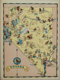
This map locates the Panama Canal Zone, Porto Rico and Virgin Islands in Central America and the West Indies' by Ruth Taylor White (1935). Vintage colour pictorial map. The buyer should aware be that the figurative depiction of certain groups - especially minorities - within some of these maps are a product of the prevailing (white) attitudes of their era; they employ racist & colonialist tropes, including exaggerated features. These maps have great value as illustrations of the social reality of their time, but today's viewer should be prepared to be offended or shocked by aspects of them, 30.5 x 23.5cm, 12 x 9.25 inchesCAPTION PRINTED BELOW PICTURE: 'This map locates the Panama Canal Zone, Porto Rico and Virgin Islands in Central America and the West Indies'
DATE PRINTED: 1935
IMAGE SIZE: Approx 30.5 x 23.5cm, 12 x 9.25 inches (Large)
TYPE: Vintage colour pictorial map. The buyer should aware be that the figurative depiction of certain groups - especially minorities - within some of these maps are a product of the prevailing (white) attitudes of their era; they employ racist & colonialist tropes, including exaggerated features. These maps have great value as illustrations of the social reality of their time, but today's viewer should be prepared to be offended or shocked by aspects of them.
CONDITION: Good; suitable for framing. Please check the scan for any blemishes prior to making your purchase. Virtually all antiquarian maps and prints are subject to some normal aging due to use and time which is not obtrusive unless otherwise stated. We offer a no questions asked return policy.
AUTHENTICITY: This is an authentic historic print, published at the date stated above. It is not a modern copy.
VERSO: There is unrelated text printed on the reverse side
ARTIST/CARTOGRAPHER/ENGRAVER: Ruth Taylor White
PROVENANCE: "Our U.S.A. - A Gay Geography", text by Frank J. Taylor; Maps by Ruth Taylor, published by Little, Brown and Company, Boston
Reserve: $115.00
Shipping: Domestic: Flat-rate of $32.00 to anywhere within the contiguous U.S. International: Foreign shipping rates are determined by destination. International shipping may be subject to VAT. Combined shipping: Please ask about combined shipping for multiple lots before bidding. Location: This item ships from the United Kingdom
Your purchase is protected:
Photos, descriptions, and estimates were prepared with the utmost care by a fully certified expert and appraiser. All items in this sale are guaranteed authentic.
In the rare event that the item did not conform to the lot description in the sale, Jasper52 specialists are here to help. Buyers may return the item for a full refund provided you notify Jasper52 within 5 days of receiving the item.
DATE PRINTED: 1935
IMAGE SIZE: Approx 30.5 x 23.5cm, 12 x 9.25 inches (Large)
TYPE: Vintage colour pictorial map. The buyer should aware be that the figurative depiction of certain groups - especially minorities - within some of these maps are a product of the prevailing (white) attitudes of their era; they employ racist & colonialist tropes, including exaggerated features. These maps have great value as illustrations of the social reality of their time, but today's viewer should be prepared to be offended or shocked by aspects of them.
CONDITION: Good; suitable for framing. Please check the scan for any blemishes prior to making your purchase. Virtually all antiquarian maps and prints are subject to some normal aging due to use and time which is not obtrusive unless otherwise stated. We offer a no questions asked return policy.
AUTHENTICITY: This is an authentic historic print, published at the date stated above. It is not a modern copy.
VERSO: There is unrelated text printed on the reverse side
ARTIST/CARTOGRAPHER/ENGRAVER: Ruth Taylor White
PROVENANCE: "Our U.S.A. - A Gay Geography", text by Frank J. Taylor; Maps by Ruth Taylor, published by Little, Brown and Company, Boston
Reserve: $115.00
Shipping:
Your purchase is protected:
Photos, descriptions, and estimates were prepared with the utmost care by a fully certified expert and appraiser. All items in this sale are guaranteed authentic.
In the rare event that the item did not conform to the lot description in the sale, Jasper52 specialists are here to help. Buyers may return the item for a full refund provided you notify Jasper52 within 5 days of receiving the item.
Buyer's Premium
- 15%
West Indies/Caribbean. Pictorial map by Ruth Taylor White 1935 old vintage
Estimate $150 - $200
Shipping & Pickup Options
Item located in United Kingdom$32 shipping in the US
Payment
Accepts seamless payments through LiveAuctioneers
See More Items From This Jasper52 Seller

TOP