


 Discovery- InteriorsBonhamsSponsored.Your ad here?
Discovery- Interiors
Bonhams
Sponsored.Your ad here?


Discovery- InteriorsBonhamsSponsored.Your ad here?
Discovery- Interiors
Bonhams
Sponsored.Your ad here?

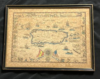
17TH C. HAND COLORED MAP OF BERMUDA - CIRCA 1670
Similar Sale History
View More Items in Maps & Atlases


![[Map] Virginia and Florida, 17th c.: Jannson, Jan. "Virginiae partis australis, et Floridae partis orientalis…." Circa 1640s. Measuring from plate-marks 50.5 x 39cm. Hand-colored. Verso with French text, old stub affixed to crease, and](https://p1.liveauctioneers.com/3532/146911/74242490_1_x.jpg?height=310&quality=70&version=1564368564)
Related Maps & Atlases


![Mercator's map of China 1606: Heading: (China, Korea & Japan) Author: Mercator, Gerard Title: China Place Published: [Antwerp] Publisher: Date Published: [1606 - printed later] Description: Copper-engraved map,](https://p1.liveauctioneers.com/642/326037/175553816_1_x.jpg?height=310&quality=70&version=1713477451)


More Items in Maps & Atlases
View More


![[Maps] Gio. Ant. Magnini, Italia, 1620: [Maps] Gio. Ant. Magnini, Italia, 1620, Giovanni Antonio Magnini. Italia, data in luce da Fabio suo figliuolo al Serenissimo Ferdinado Gonzaga Duca di Matoua edi Monserrato etc. Bologna, for Sebastian](https://p1.liveauctioneers.com/188/326797/176317457_1_x.jpg?height=310&quality=70&version=1713847031)

Recommended Transportation & Travel Collectibles
View More


Item Details
Description
17TH C. HAND COLORED MAP OF BERMUDA - CIRCA 1670 - TITLED "MAPPA AESTIVARUM INSULARUM ALIAS BARMUDAS" - FRAMED AND IN VERY GOOD CONDITION - FRAME 21 3/4" X 19 1/8", SIGHT 14 3/4" X 11 3/4"
Buyer's Premium
- 23%
17TH C. HAND COLORED MAP OF BERMUDA - CIRCA 1670
Estimate $500 - $1,500
26 bidders are watching this item.
Shipping & Pickup Options
Item located in Bennington, VT, usSee Policy for Shipping
Local Pickup Available
Payment
Accepts seamless payments through LiveAuctioneers

TOP