


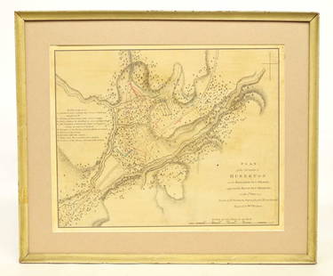
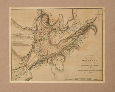
Map, A Plan of the Action at Bunkers Hill 1775
Similar Sale History
View More Items in Maps & Atlases


![L'Africa. DE ROSSI / SANSON 1677 old antique vintage map plan chart: TITLE/CONTENT OF MAP: L'Africa [Africa] DATE PRINTED: 1677 IMAGE SIZE: Approx 42.5 x 57.0cm, 16.75 x 22.25 inches (Large) TYPE: Antique 17th century folio atlas map CONDITION: Good; suitable for frami](https://p1.liveauctioneers.com/5584/308981/165185503_1_x.jpg?height=310&quality=70&version=1699996168)

![L'Irlanda o'vero Hibernia. Ireland. DE ROSSI 1689 old antique map plan chart: TITLE/CONTENT OF MAP: L'Irlanda o'vero Hibernia [Ireland, or Hibernia] DATE PRINTED: 1689 IMAGE SIZE: Approx 59.0 x 45.0cm, 23.25 x 17.75 inches (Large) TYPE: Antique 17th century folio atlas map COND](https://p1.liveauctioneers.com/5584/326140/175577116_1_x.jpg?height=310&quality=70&version=1713288521)


Related Maps & Atlases


More Items in Maps & Atlases
View More


![[Maps] Martin Zeiler, Itinerarium Italiae, 1640: [Maps] Martin Zeiler, Itinerarium Italiae, 1640, Martini Zeilleri. Itinerarium Italiae Nov-Antiquae: oder, Raiss-Beschreibung durch Italien, Matthaus Merian, Frankfurt, 40 plates, most double-page, in](https://p1.liveauctioneers.com/188/326797/176317459_1_x.jpg?height=310&quality=70&version=1713847031)


![[Maps] Gio. Ant. Magnini, Italia, 1620: [Maps] Gio. Ant. Magnini, Italia, 1620, Giovanni Antonio Magnini. Italia, data in luce da Fabio suo figliuolo al Serenissimo Ferdinado Gonzaga Duca di Matoua edi Monserrato etc. Bologna, for Sebastian](https://p1.liveauctioneers.com/188/326797/176317457_1_x.jpg?height=310&quality=70&version=1713847031)


Recommended Transportation & Travel Collectibles
View More


Item Details
Description
Framed hand-colored engraved Revolutionary War battle plan map entitled: "A Plan of the Action at Bunkers Hill on the 17th of June 1775. Between His Majesty 's Troops, Under the Command of Major General Howe, and the Rebel Forces. By Lieut Page of the Engineers, who acted as Aide de Camp to General Howe in that Action". This map with "Engraved for Frothingham's History", a fine mid-19th century reproduction of the important battle plan map, likely a fold-out map from "History of the siege of Boston, and of the battles of Lexington, Concord, and Bunker Hill: Also, an account of the Bunker Hill monument, with illustrative documents" by Richard Frothingham, published 1849. (The book went through a number of printings throughout the second half of the 19th C; the map may be from a later edition.) Not examined out of frame. Upper right corner chipped. Creases. Closed tear. Frame, approx. 24 3/8" x 22". Sight, approx. 18 1/2" x 16 3/8".Provenance: a private Northern Virginia collection.
Buyer's Premium
- 25%
Map, A Plan of the Action at Bunkers Hill 1775
Estimate $300 - $500
14 bidders are watching this item.
Shipping & Pickup Options
Item located in Madison, VA, usSee Policy for Shipping
Local Pickup Available
Payment
Accepts seamless payments through LiveAuctioneers

TOP