


 Weekly: JewelryBonhamsSponsored.Your ad here?
Weekly: Jewelry
Bonhams
Sponsored.Your ad here?


 DesignChristie'sSponsored.Your ad here?
Design
Christie's
Sponsored.Your ad here?


DesignChristie'sSponsored.Your ad here?
Design
Christie's
Sponsored.Your ad here?

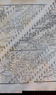
Montana Recreation Area Map; 1903 [151395]
Similar Sale History
View More Items in Maps & Atlases

![San Diego with pictorial recreation map 1935: Heading: (California - San Diego) Author: Title: Map of San Diego California City and County - with two maps, one a pictorial bird's-eye map Place Published: [San Diego] Publisher:Lowell E. Jones <](https://p1.liveauctioneers.com/642/218849/112379283_1_x.jpg?height=310&quality=70&version=1631923877)
![Montana Maps by Cram, 2 c1910-30 [166811]: 2 Montana maps by Cram. Superior Map of Montana c. 1910, 45x50", tape repairs and tears. c. 1930 color Latest Official Survey Montana, 44x49", some edge chips and small tears. Please inspect. Montana](https://p1.liveauctioneers.com/2699/324080/174413224_1_x.jpg?height=310&quality=70&version=1711485545)

![1893 Civil War Map of Murfreesborough TN Area -- Map of the Battle of Murfreesborough [with]: Title: 1893 Civil War Map of Murfreesborough TN Area -- Map of the Battle of Murfreesborough [with] ...Stone River Campaign… [with] …Battlee Before Murfreesborough, Tenn... [Plate XXXI] Cartograph](https://p1.liveauctioneers.com/5584/293457/155766022_1_x.jpg?height=310&quality=70&version=1687903812)


![Railroad Commission Map of Montana, 1908 [166812]: 1908 Railroad Commission of Montana map, 41x53". Color state borders and railroad lines. Tape repairs, small edge tears and wear. Please inspect. Montana Stuart Mackenzie Montana Ephemera Collection](https://p1.liveauctioneers.com/2699/299063/159201768_1_x.jpg?height=310&quality=70&version=1692045182)


Related Maps & Atlases


![1893 Civil War Map of Knoxville Area -- Topographical Map of the Approaches and Defences of: Title: 1893 Civil War Map of Knoxville Area -- Topographical Map of the Approaches and Defences of Knoxville, E. Tennessee… [with] Map No. 1 The Chickamauga Campaign... [Plate XLVIII] Cartograph](https://p1.liveauctioneers.com/5584/331064/178466410_1_x.jpg?height=310&quality=70&version=1716924723)


![Large Map of Montana: Large Map of Montana With map of Utah and Wyoming [separately] on versos Cartographer: George Franklin Cram Dated: Circa 1900 Type: Color Lithograph Dimensions: 14 1/2](https://p1.liveauctioneers.com/5614/330257/178045315_1_x.jpg?height=310&quality=70&version=1716032806)


![Helena Mining District Map, 1915 1915 [166813]: 1915 Montana Mining District map by The Engineering Corporation. 61x42". Some edge tears, chip, tape repairs etc. Please inspect. Helena Montana Stuart Mackenzie Montana Ephemera Collection](https://p1.liveauctioneers.com/2699/331495/178785759_1_x.jpg?height=310&quality=70&version=1717094933)


![Map of Maryville, Montana Gold Mines [180908]: Folded map showing relative location, Maryville Gold Mining Company with producing mines in vicinity of Maryville, Montana, in blue ink. Parts of the map are taped along the seams. 35x28 inches unfold](https://p1.liveauctioneers.com/2699/331495/178785782_1_x.jpg?height=310&quality=70&version=1717094933)
More Items in Maps & Atlases
View More![[MAP]. TODESCHI, Pietro. [Nova et Acurata Totius Americae Tabula auct. G.I. Blaeu] America quarta: [MAP]. TODESCHI, Pietro. [Nova et Acurata Totius Americae Tabula auct. G.I. Blaeu] America quarta pars orbis quam plerunq, nuvum orbem appellitant primo detecta est anno 1492 a Christophoro Columbo...](https://p1.liveauctioneers.com/197/329395/177650542_1_x.jpg?height=310&quality=70&version=1715364962)
![[MAPS]. HOMANN, Johann Baptist, HOMANN HEIRS, and Georg Matthäus SEUTTER. [Composite Atlas].: [MAPS]. HOMANN, Johann Baptist (1663-1724), HOMANN HEIRS, and Georg Matthäus SEUTTER (1678-1757). [Composite Atlas]. [Nuremberg, Augsburg, and others: Homann Heirs and others, maps dated between](https://p1.liveauctioneers.com/197/329395/177650530_1_x.jpg?height=310&quality=70&version=1715364962)


![[MAP]. ORTELIUS, Abraham. Americae Sive Novi Orbis, Nova Descriptio. 1573.: [MAP]. ORTELIUS, Abraham (1527-1598). Americae Sive Novi Orbis, Nova Descriptio. Antwerp, 1573. Engraved map with hand-coloring. Framed and double glazed, visible area 375 x 521 mm (unexamined out of](https://p1.liveauctioneers.com/197/329395/177650534_1_x.jpg?height=310&quality=70&version=1715364962)

![Set of Twelve Satirical Anthropomorphic Maps of Europe: [SATIRICAL MAPS] A set of twelve satirical anthropomorphic maps of Europe. London: circa 1868. A set of 12 (believed complete) lithographed maps by Vincent Brooks, Day & Son, London, each offering](https://p1.liveauctioneers.com/292/330597/178279264_1_x.jpg?height=310&quality=70&version=1716409282)


![[MAP]. ORTELIUS, Abraham. Turcici Imperii Descriptio.1592.: [MAP]. ORTELIUS, Abraham (1527-1598). Turcici Imperii Descriptio. Antwerp, 1592. Engraved map with hand-coloring. Matted, framed, and double glazed, sight 406 x 521 mm (unexamined out of frame). Decor](https://p1.liveauctioneers.com/197/329395/177650538_1_x.jpg?height=310&quality=70&version=1715364962)
![[MAP]. ORTELIUS, Abraham. Romani Imperii Imago. 1592.: [MAP]. ORTELIUS, Abraham (1527-1598). Romani Imperii Imago. Antwerp, 1592. Engraved map with hand-coloring. Matted, framed, and double glazed, visible area 381 x 521 mm (unexamined out of frame). 6 de](https://p1.liveauctioneers.com/197/329395/177650537_1_x.jpg?height=310&quality=70&version=1715364962)
![[MAP]. SPEED, John. A New Mappe of the Romane Empire. 1676.: [MAP]. SPEED, John (ca 1551-1629). A New Mappe of the Romane Empire. London: Basset & Chiswell, 1676. Engraved map with hand-coloring. Framed and double glazed, sight 419 x 559 mm. Decorative cartouch](https://p1.liveauctioneers.com/197/329395/177650541_1_x.jpg?height=310&quality=70&version=1715364962)

![[MAP]. ORTELIUS, Abraham. Aevi Veteris, Typus Geographicus. 1601.: [MAP]. ORTELIUS, Abraham (1527-1598). Aevi Veteris, Typus Geographicus. Antwerp, 1601. Engraved map with hand-coloring. Matted, framed, and double glazed, visible area 343 x 470 mm (unexamined out of](https://p1.liveauctioneers.com/197/329395/177650532_1_x.jpg?height=310&quality=70&version=1715364962)
Recommended Transportation & Travel Collectibles
View More


![Montana Recreation Area Map; 1903 [151395]](https://p1.liveauctioneers.com/2699/254720/132471978_1_x.jpg?quality=1&version=1657566291&width=486)
![Montana Recreation Area Map; 1903 [151395]](https://p1.liveauctioneers.com/2699/254720/132471978_1_x.jpg?quality=80&version=1657566291)
Item Details
Description
Land Classification Map of Little Belt Mountains Quadrangle and Part of Fort Benton Quadrangle, Montana. Land classification and timber estimates by John B. Leiberg, 1903. Topographic map showing woodlands, forests, grazing land, bare rocks, and agricultural areas, printed in color. 28.5 x 15.5, good condition. Date: Country (if not USA): State: MontanaCity: Provenance:
Buyer's Premium
- 30%
Montana Recreation Area Map; 1903 [151395]
Estimate $100 - $120
1 bidder is watching this item.
Shipping & Pickup Options
Item located in Reno, NV, usOffers In-House Shipping
Local Pickup Available
Payment
Accepts seamless payments through LiveAuctioneers

Related Searches
TOP